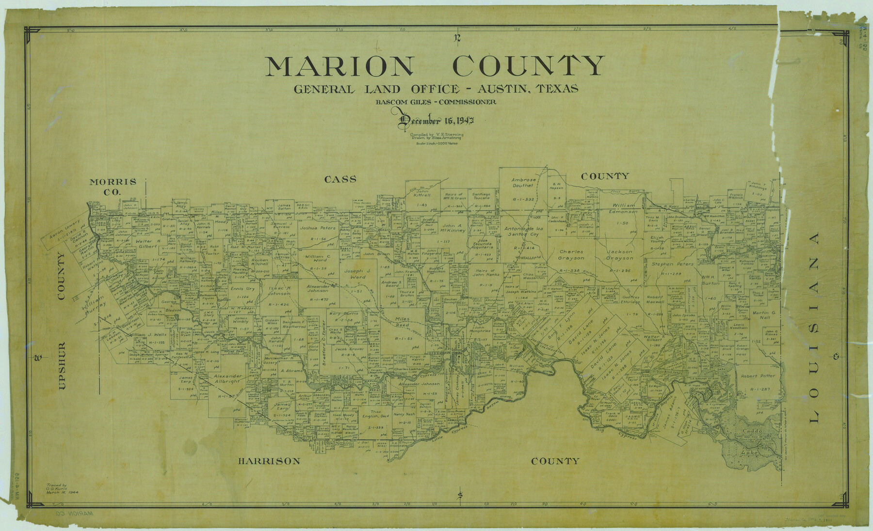
Marion County
RM-4-155
-
Map/Doc
1888
-
Collection
General Map Collection
-
Object Dates
1943/12/16 (Creation Date)
-
People and Organizations
Texas General Land Office (Publisher)
Bascom Giles (GLO Commissioner)
Eltea Armstrong (Draftsman)
Victor E. Sterzing (Compiler)
-
Counties
Marion
-
Subjects
County
-
Height x Width
28.1 x 46.2 inches
71.4 x 117.3 cm
-
Comments
Traced March 16, 1944 by O. G. Kurio.
Part of: General Map Collection
Matagorda County Working Sketch 23

Print $20.00
- Digital $50.00
Matagorda County Working Sketch 23
1968
Size 27.4 x 35.8 inches
Map/Doc 70881
Menard County Sketch File 10

Print $20.00
- Digital $50.00
Menard County Sketch File 10
1885
Size 32.5 x 18.0 inches
Map/Doc 12074
Nolan County Sketch File 9

Print $26.00
- Digital $50.00
Nolan County Sketch File 9
1902
Size 14.3 x 9.0 inches
Map/Doc 32465
Amistad International Reservoir on Rio Grande 70

Print $20.00
- Digital $50.00
Amistad International Reservoir on Rio Grande 70
1949
Size 28.4 x 39.7 inches
Map/Doc 73356
Presidio County Sketch File 69b

Print $6.00
- Digital $50.00
Presidio County Sketch File 69b
1919
Size 11.2 x 8.8 inches
Map/Doc 34666
Wood County Working Sketch 9

Print $20.00
- Digital $50.00
Wood County Working Sketch 9
1943
Size 36.0 x 28.5 inches
Map/Doc 62009
Pecos County Rolled Sketch JAS

Print $20.00
- Digital $50.00
Pecos County Rolled Sketch JAS
1937
Size 34.9 x 31.4 inches
Map/Doc 9744
Flight Mission No. DAG-24K, Frame 128, Matagorda County

Print $20.00
- Digital $50.00
Flight Mission No. DAG-24K, Frame 128, Matagorda County
1953
Size 17.2 x 22.5 inches
Map/Doc 86546
Railroad Track Map, H&TCRRCo., Falls County, Texas

Print $4.00
- Digital $50.00
Railroad Track Map, H&TCRRCo., Falls County, Texas
1918
Size 11.8 x 18.6 inches
Map/Doc 62840
Irion County Sketch File 11

Print $20.00
- Digital $50.00
Irion County Sketch File 11
1937
Size 22.2 x 17.5 inches
Map/Doc 11826
Brewster County Working Sketch 41

Print $20.00
- Digital $50.00
Brewster County Working Sketch 41
1945
Size 30.3 x 38.4 inches
Map/Doc 67575
Lavaca County Working Sketch 1

Print $20.00
- Digital $50.00
Lavaca County Working Sketch 1
1905
Size 18.0 x 22.5 inches
Map/Doc 70354
You may also like
Flight Mission No. CRC-4R, Frame 97, Chambers County

Print $20.00
- Digital $50.00
Flight Mission No. CRC-4R, Frame 97, Chambers County
1956
Size 18.6 x 22.2 inches
Map/Doc 84894
Val Verde County Working Sketch 5

Print $20.00
- Digital $50.00
Val Verde County Working Sketch 5
1909
Size 13.0 x 29.8 inches
Map/Doc 72140
General Highway Map, Foard County, Texas

Print $20.00
General Highway Map, Foard County, Texas
1961
Size 18.2 x 24.6 inches
Map/Doc 79468
Dimmit County Sketch File 10

Print $20.00
- Digital $50.00
Dimmit County Sketch File 10
Size 23.5 x 22.6 inches
Map/Doc 11338
Schleicher County Sketch File 16

Print $6.00
- Digital $50.00
Schleicher County Sketch File 16
Size 11.6 x 15.4 inches
Map/Doc 36506
San Jacinto County Boundary File 1

Print $6.00
- Digital $50.00
San Jacinto County Boundary File 1
Size 9.6 x 8.4 inches
Map/Doc 58548
Burnet County Rolled Sketch D

Print $20.00
- Digital $50.00
Burnet County Rolled Sketch D
1924
Size 47.3 x 40.8 inches
Map/Doc 8541
Hockley County Sketch Mineral Application Number 38245

Print $20.00
- Digital $50.00
Hockley County Sketch Mineral Application Number 38245
1946
Size 40.6 x 18.5 inches
Map/Doc 92243
A Map of Dallas County

Print $20.00
- Digital $50.00
A Map of Dallas County
1855
Size 18.4 x 18.8 inches
Map/Doc 3465
San Saba County Working Sketch 10

Print $40.00
- Digital $50.00
San Saba County Working Sketch 10
1985
Size 33.4 x 52.9 inches
Map/Doc 63798
Flight Mission No. BRA-16M, Frame 118, Jefferson County

Print $20.00
- Digital $50.00
Flight Mission No. BRA-16M, Frame 118, Jefferson County
1953
Size 18.6 x 22.1 inches
Map/Doc 85728
Schleicher County Rolled Sketch 10

Print $20.00
- Digital $50.00
Schleicher County Rolled Sketch 10
Size 30.1 x 25.8 inches
Map/Doc 7753