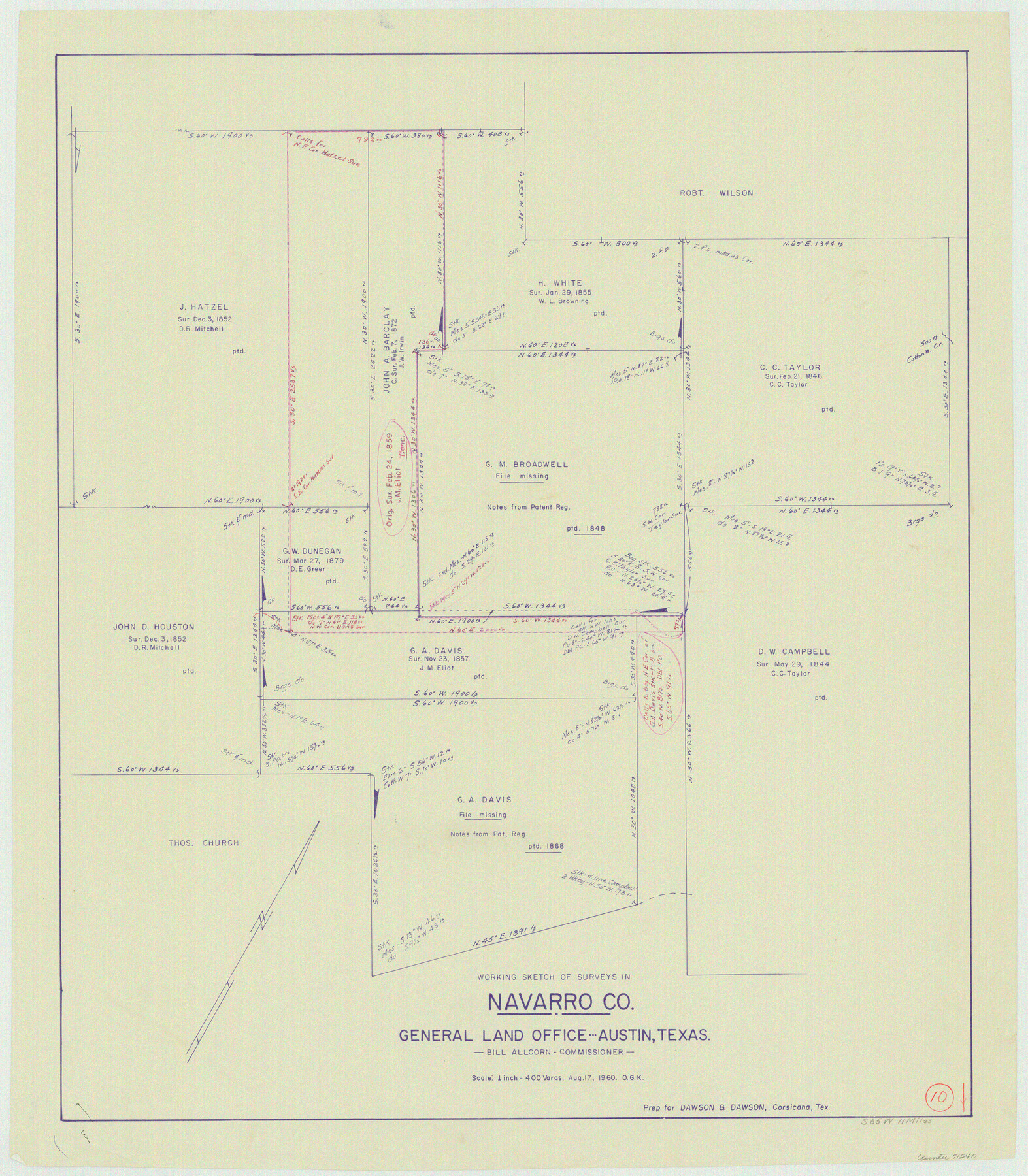
Navarro County Working Sketch 10
-
Map/Doc
71240
-
Collection
General Map Collection
-
Object Dates
8/17/1960 (Creation Date)
-
People and Organizations
Otto G. Kurio (Draftsman)
-
Counties
Navarro
-
Subjects
Surveying Working Sketch
-
Height x Width
29.7 x 26.0 inches
75.4 x 66.0 cm
-
Scale
1" = 400 varas
Part of: General Map Collection
Starr County Boundary File 44a

Print $57.00
- Digital $50.00
Starr County Boundary File 44a
Size 9.3 x 9.4 inches
Map/Doc 58827
Floyd County Sketch File 25

Print $14.00
- Digital $50.00
Floyd County Sketch File 25
1912
Size 11.5 x 9.0 inches
Map/Doc 22782
Comanche County Working Sketch 18

Print $20.00
- Digital $50.00
Comanche County Working Sketch 18
1973
Size 18.3 x 25.2 inches
Map/Doc 68152
Crockett County Sketch File 58

Print $20.00
- Digital $50.00
Crockett County Sketch File 58
1932
Size 17.9 x 23.2 inches
Map/Doc 11226
Cass County Working Sketch 47a

Print $20.00
- Digital $50.00
Cass County Working Sketch 47a
1991
Size 29.5 x 39.5 inches
Map/Doc 67950
Fort Bend County Working Sketch 13

Print $20.00
- Digital $50.00
Fort Bend County Working Sketch 13
1946
Size 29.0 x 29.3 inches
Map/Doc 69218
Map of Texas in 1830 Showing Spanish Colonies

Print $20.00
- Digital $50.00
Map of Texas in 1830 Showing Spanish Colonies
Size 41.1 x 42.0 inches
Map/Doc 73588
Right of Way and Track Map, Houston & Texas Central R.R. operated by the T. and N. O. R.R., Fort Worth Branch

Print $40.00
- Digital $50.00
Right of Way and Track Map, Houston & Texas Central R.R. operated by the T. and N. O. R.R., Fort Worth Branch
1918
Size 30.7 x 57.3 inches
Map/Doc 64782
Marion County Rolled Sketch F

Print $40.00
- Digital $50.00
Marion County Rolled Sketch F
1937
Size 43.5 x 67.1 inches
Map/Doc 9487
Crosby County Rolled Sketch D

Print $20.00
- Digital $50.00
Crosby County Rolled Sketch D
Size 23.9 x 23.6 inches
Map/Doc 5643

Railroad Track Map, H&TCRRCo., Falls County, Texas

Print $4.00
- Digital $50.00
Railroad Track Map, H&TCRRCo., Falls County, Texas
1918
Size 11.6 x 18.6 inches
Map/Doc 62848
You may also like
Kimble County Working Sketch 63

Print $20.00
- Digital $50.00
Kimble County Working Sketch 63
1964
Size 31.2 x 34.2 inches
Map/Doc 70131
The Republic County of Colorado. January 19, 1841

Print $20.00
The Republic County of Colorado. January 19, 1841
2020
Size 18.4 x 21.7 inches
Map/Doc 96124
[Beaumont, Sour Lake and Western Ry. Right of Way and Alignment - Frisco]
![64126, [Beaumont, Sour Lake and Western Ry. Right of Way and Alignment - Frisco], General Map Collection](https://historictexasmaps.com/wmedia_w700/maps/64126.tif.jpg)
Print $20.00
- Digital $50.00
[Beaumont, Sour Lake and Western Ry. Right of Way and Alignment - Frisco]
1910
Size 20.1 x 46.1 inches
Map/Doc 64126
Flight Mission No. DCL-6C, Frame 127, Kenedy County

Print $20.00
- Digital $50.00
Flight Mission No. DCL-6C, Frame 127, Kenedy County
1943
Size 18.5 x 22.3 inches
Map/Doc 85957
Gonzales County

Print $40.00
- Digital $50.00
Gonzales County
1986
Size 39.9 x 52.0 inches
Map/Doc 77292
Stephens County Sketch File 5

Print $6.00
- Digital $50.00
Stephens County Sketch File 5
Size 10.0 x 13.3 inches
Map/Doc 37019
Travis County Boundary File 29

Print $4.00
- Digital $50.00
Travis County Boundary File 29
Size 13.2 x 8.4 inches
Map/Doc 59467
Kendall County Sketch File 8

Print $4.00
- Digital $50.00
Kendall County Sketch File 8
1879
Size 10.1 x 8.0 inches
Map/Doc 28690
Controlled Mosaic by Jack Amman Photogrammetric Engineers, Inc - Sheet 18

Print $20.00
- Digital $50.00
Controlled Mosaic by Jack Amman Photogrammetric Engineers, Inc - Sheet 18
1954
Size 19.4 x 24.0 inches
Map/Doc 83463
Brewster County Sketch File NS-2

Print $14.00
- Digital $50.00
Brewster County Sketch File NS-2
1913
Size 14.3 x 8.8 inches
Map/Doc 15946
Flight Mission No. BRE-1P, Frame 137, Nueces County

Print $20.00
- Digital $50.00
Flight Mission No. BRE-1P, Frame 137, Nueces County
1956
Size 18.7 x 22.6 inches
Map/Doc 86697
Montague County Boundary File 2a

Print $8.00
- Digital $50.00
Montague County Boundary File 2a
Size 13.0 x 8.3 inches
Map/Doc 57410