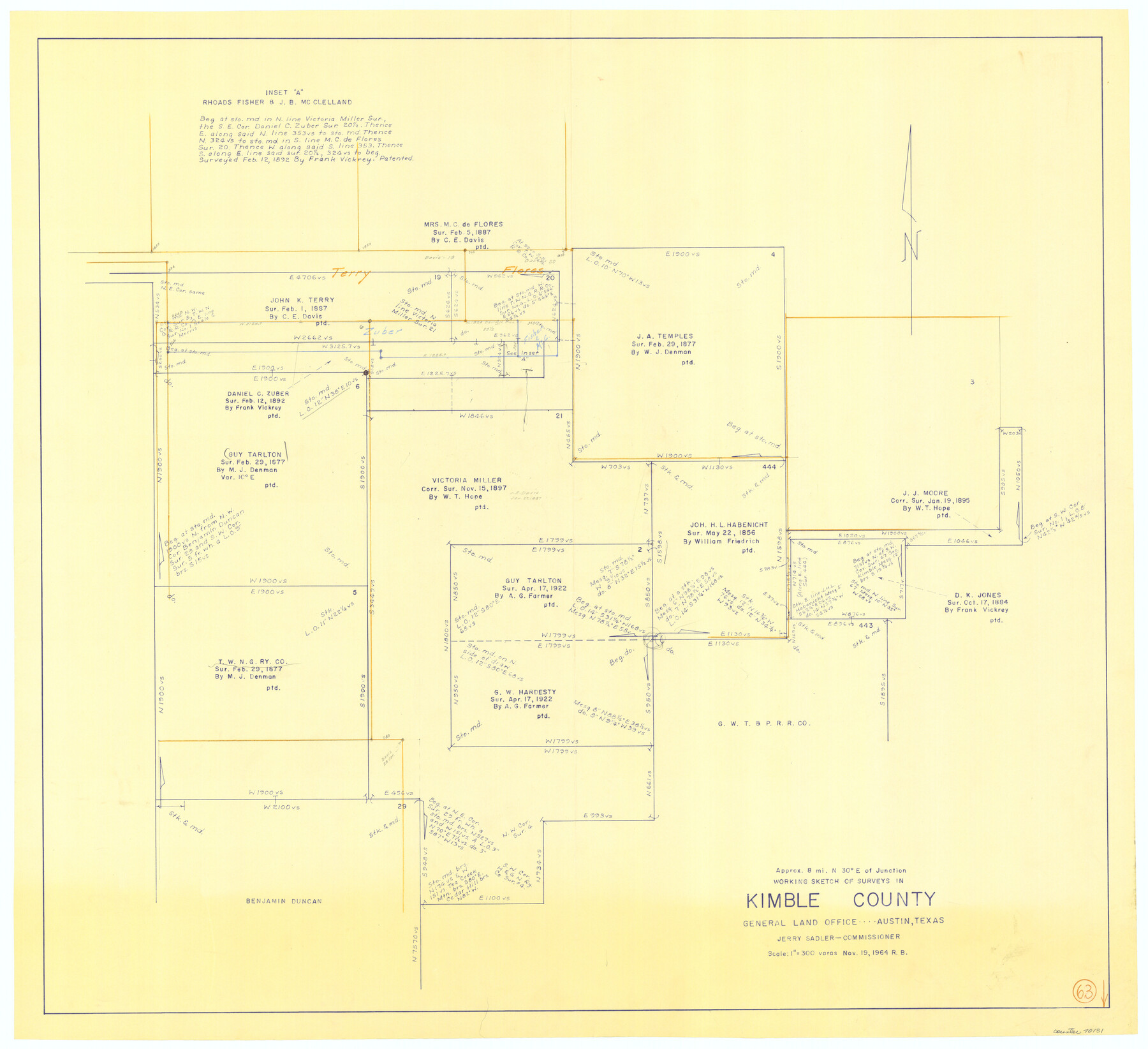
Kimble County Working Sketch 63
-
Map/Doc
70131
-
Collection
General Map Collection
-
Object Dates
11/19/1964 (Creation Date)
-
People and Organizations
Roy Buckholts (Draftsman)
-
Counties
Kimble
-
Subjects
Surveying Working Sketch
-
Height x Width
31.2 x 34.2 inches
79.3 x 86.9 cm
-
Scale
1" = 300 varas
Part of: General Map Collection
Crockett County Rolled Sketch 43

Print $40.00
- Digital $50.00
Crockett County Rolled Sketch 43
1937
Size 31.4 x 63.2 inches
Map/Doc 8708
Fannin County Boundary File 3

Print $36.00
- Digital $50.00
Fannin County Boundary File 3
Size 13.2 x 8.8 inches
Map/Doc 53295
Brewster County Rolled Sketch 114

Print $20.00
- Digital $50.00
Brewster County Rolled Sketch 114
1964
Size 11.7 x 18.6 inches
Map/Doc 5266
Dickens County Rolled Sketch 10

Print $20.00
- Digital $50.00
Dickens County Rolled Sketch 10
Size 43.0 x 31.9 inches
Map/Doc 8789
Map of the country scouted by Colonels McKenzie and Shafter, Capt. R.P. Wilson and others in the years, 1874 & 1875

Print $20.00
- Digital $50.00
Map of the country scouted by Colonels McKenzie and Shafter, Capt. R.P. Wilson and others in the years, 1874 & 1875
1876
Size 43.0 x 31.8 inches
Map/Doc 62972

Coryell County

Print $20.00
- Digital $50.00
Coryell County
1880
Size 25.6 x 25.6 inches
Map/Doc 3444
Rockwall County Working Sketch 1

Print $20.00
- Digital $50.00
Rockwall County Working Sketch 1
Size 12.5 x 18.4 inches
Map/Doc 63593
Harris County Sketch File 33a

Print $20.00
- Digital $50.00
Harris County Sketch File 33a
Size 34.1 x 30.0 inches
Map/Doc 10478
Chambers County Sketch File 16

Print $4.00
- Digital $50.00
Chambers County Sketch File 16
Size 7.9 x 12.7 inches
Map/Doc 17566
Nueces County Rolled Sketch 59

Print $20.00
- Digital $50.00
Nueces County Rolled Sketch 59
1979
Size 38.8 x 27.7 inches
Map/Doc 6906
Stonewall County

Print $20.00
- Digital $50.00
Stonewall County
1933
Size 47.6 x 39.5 inches
Map/Doc 73295
You may also like
Clarendon, Texas, Donley Co.

Print $20.00
Clarendon, Texas, Donley Co.
1890
Size 15.7 x 26.6 inches
Map/Doc 89078
Cochran County Rolled Sketch 5

Print $20.00
- Digital $50.00
Cochran County Rolled Sketch 5
1949
Size 21.5 x 22.0 inches
Map/Doc 5502
Edwards County Working Sketch 134

Print $40.00
- Digital $50.00
Edwards County Working Sketch 134
1986
Size 29.4 x 54.2 inches
Map/Doc 69010
Pecos County Rolled Sketch 29

Print $40.00
- Digital $50.00
Pecos County Rolled Sketch 29
1890
Size 27.3 x 49.9 inches
Map/Doc 9690
Flight Mission No. DAG-18K, Frame 74, Matagorda County

Print $20.00
- Digital $50.00
Flight Mission No. DAG-18K, Frame 74, Matagorda County
1952
Size 18.5 x 22.4 inches
Map/Doc 86367
Morris County Working Sketch 6

Print $20.00
- Digital $50.00
Morris County Working Sketch 6
1985
Size 35.8 x 36.7 inches
Map/Doc 71205
Flight Mission No. DQN-7K, Frame 37, Calhoun County

Print $20.00
- Digital $50.00
Flight Mission No. DQN-7K, Frame 37, Calhoun County
1953
Size 18.4 x 22.1 inches
Map/Doc 84475
Freestone County Working Sketch 24

Print $20.00
- Digital $50.00
Freestone County Working Sketch 24
1982
Size 24.5 x 25.3 inches
Map/Doc 69266
Winkler County Working Sketch 7

Print $20.00
- Digital $50.00
Winkler County Working Sketch 7
1958
Size 45.4 x 30.2 inches
Map/Doc 72601
Zavala County Working Sketch 1

Print $20.00
- Digital $50.00
Zavala County Working Sketch 1
Size 21.2 x 16.3 inches
Map/Doc 62076
Smith County Working Sketch 2

Print $20.00
- Digital $50.00
Smith County Working Sketch 2
Size 16.3 x 13.1 inches
Map/Doc 63887
South Part Brewster Co.

Print $40.00
- Digital $50.00
South Part Brewster Co.
Size 48.7 x 32.8 inches
Map/Doc 92468