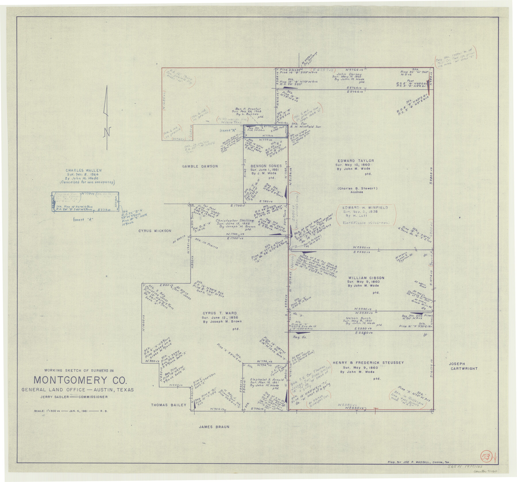
Montgomery County Working Sketch 53
-
Map/Doc
71160
-
Collection
General Map Collection
-
Object Dates
1/6/1961 (Creation Date)
-
People and Organizations
Roy Buckholts (Draftsman)
-
Counties
Montgomery
-
Subjects
Surveying Working Sketch
-
Height x Width
28.2 x 30.2 inches
71.6 x 76.7 cm
-
Scale
1" = 300 varas
Part of: General Map Collection
Live Oak County Rolled Sketch 5

Print $20.00
- Digital $50.00
Live Oak County Rolled Sketch 5
1947
Size 33.6 x 32.2 inches
Map/Doc 9454
Map representing the surveys made in Bexar County

Print $40.00
- Digital $50.00
Map representing the surveys made in Bexar County
1839
Size 75.7 x 35.1 inches
Map/Doc 93365
Nueces County NRC Article 33.136 Sketch 22

Print $42.00
Nueces County NRC Article 33.136 Sketch 22
2023
Map/Doc 97180
Nueces County Working Sketch 11

Print $20.00
- Digital $50.00
Nueces County Working Sketch 11
1965
Size 20.2 x 44.1 inches
Map/Doc 71313
Armstrong County Sketch File A-6

Print $40.00
- Digital $50.00
Armstrong County Sketch File A-6
1919
Size 18.3 x 15.8 inches
Map/Doc 10847
Nueces County Sketch File 25B

Print $20.00
- Digital $50.00
Nueces County Sketch File 25B
1894
Size 17.6 x 24.6 inches
Map/Doc 42183
Zapata County Working Sketch 9

Print $20.00
- Digital $50.00
Zapata County Working Sketch 9
1951
Size 34.9 x 18.1 inches
Map/Doc 62060
Flight Mission No. CUG-3P, Frame 90, Kleberg County

Print $20.00
- Digital $50.00
Flight Mission No. CUG-3P, Frame 90, Kleberg County
1956
Size 18.6 x 22.3 inches
Map/Doc 86260
Reeves County Working Sketch 5

Print $20.00
- Digital $50.00
Reeves County Working Sketch 5
1938
Size 38.0 x 32.4 inches
Map/Doc 63448
Lampasas County

Print $20.00
- Digital $50.00
Lampasas County
1972
Size 34.4 x 43.4 inches
Map/Doc 73214
Val Verde County Working Sketch 82

Print $20.00
- Digital $50.00
Val Verde County Working Sketch 82
1973
Size 42.1 x 33.1 inches
Map/Doc 72217

You may also like
Crockett County Sketch File 6

Print $20.00
- Digital $50.00
Crockett County Sketch File 6
1877
Size 22.2 x 17.2 inches
Map/Doc 3457
Limestone County Sketch File A

Print $40.00
- Digital $50.00
Limestone County Sketch File A
1833
Size 15.7 x 12.8 inches
Map/Doc 30149
Newton County Rolled Sketch 19

Print $20.00
- Digital $50.00
Newton County Rolled Sketch 19
1956
Size 42.1 x 33.5 inches
Map/Doc 6848
Parker County Rolled Sketch 1

Print $20.00
- Digital $50.00
Parker County Rolled Sketch 1
1878
Size 19.8 x 24.6 inches
Map/Doc 7202
Eastland County Working Sketch 13

Print $20.00
- Digital $50.00
Eastland County Working Sketch 13
1919
Size 34.0 x 38.0 inches
Map/Doc 68794
Flight Mission No. DAG-21K, Frame 119, Matagorda County

Print $20.00
- Digital $50.00
Flight Mission No. DAG-21K, Frame 119, Matagorda County
1952
Size 18.6 x 22.5 inches
Map/Doc 86445
Montgomery County

Print $20.00
- Digital $50.00
Montgomery County
1871
Size 21.5 x 23.9 inches
Map/Doc 4598
Panola County Working Sketch 9

Print $20.00
- Digital $50.00
Panola County Working Sketch 9
1943
Map/Doc 71418
Flight Mission No. CRK-8P, Frame 117, Refugio County

Print $20.00
- Digital $50.00
Flight Mission No. CRK-8P, Frame 117, Refugio County
1956
Size 18.1 x 22.0 inches
Map/Doc 86972
[Blocks R31E-R34E Township 11-13]
![92039, [Blocks R31E-R34E Township 11-13], Twichell Survey Records](https://historictexasmaps.com/wmedia_w700/maps/92039-1.tif.jpg)
Print $20.00
- Digital $50.00
[Blocks R31E-R34E Township 11-13]
Size 21.7 x 16.7 inches
Map/Doc 92039
Irion County Rolled Sketch 6

Print $20.00
- Digital $50.00
Irion County Rolled Sketch 6
Size 23.6 x 39.9 inches
Map/Doc 6320
Ward County Working Sketch 11

Print $20.00
- Digital $50.00
Ward County Working Sketch 11
1947
Size 22.1 x 19.8 inches
Map/Doc 72317