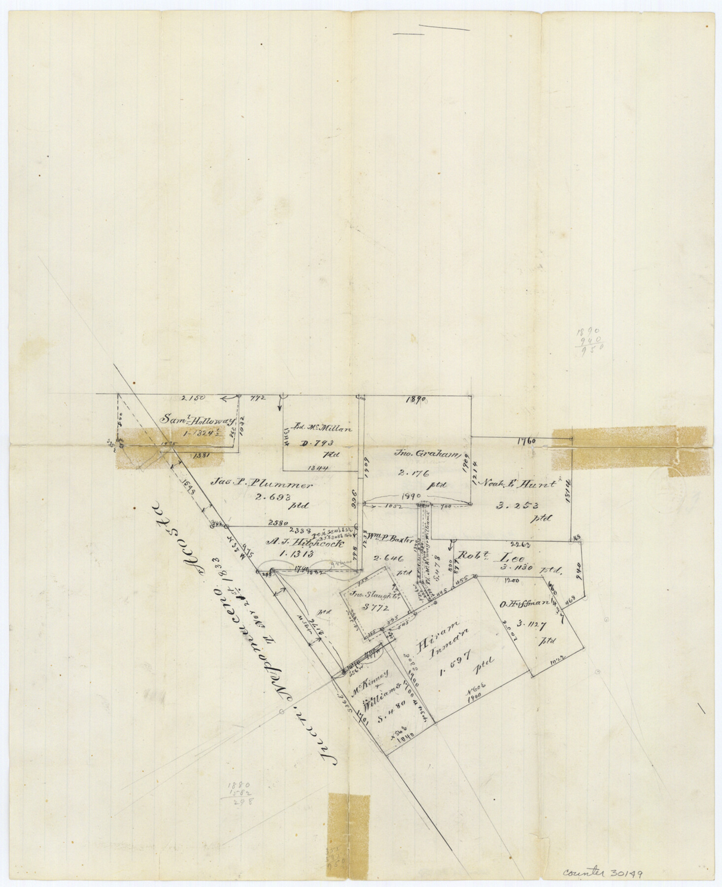
Limestone County Sketch File A
[Sketch of surveys east of Groesbeck]
-
Map/Doc
30149
-
Collection
General Map Collection
-
Object Dates
11/21/1833 (Creation Date)
-
Counties
Limestone Freestone
-
Subjects
Surveying Sketch File
-
Height x Width
15.7 x 12.8 inches
39.9 x 32.5 cm
-
Medium
paper, manuscript
Part of: General Map Collection
Menard County Sketch File 8

Print $20.00
- Digital $50.00
Menard County Sketch File 8
Size 19.7 x 28.5 inches
Map/Doc 12073
Colorado River, Bay City to Matagorda Sheet 2

Print $40.00
- Digital $50.00
Colorado River, Bay City to Matagorda Sheet 2
1924
Size 86.2 x 32.8 inches
Map/Doc 65260
Flight Mission No. CUG-3P, Frame 83, Kleberg County

Print $20.00
- Digital $50.00
Flight Mission No. CUG-3P, Frame 83, Kleberg County
1956
Size 18.7 x 22.4 inches
Map/Doc 86258
Flight Mission No. BRA-7M, Frame 193, Jefferson County

Print $20.00
- Digital $50.00
Flight Mission No. BRA-7M, Frame 193, Jefferson County
1953
Size 18.7 x 22.4 inches
Map/Doc 85561
Right of Way and Track Map Houston & Texas Central R.R. operated by the T. & N.O. R.R. Co., Austin Branch

Print $40.00
- Digital $50.00
Right of Way and Track Map Houston & Texas Central R.R. operated by the T. & N.O. R.R. Co., Austin Branch
1918
Size 26.0 x 57.9 inches
Map/Doc 64557
Robertson County Rolled Sketch 1A

Print $20.00
- Digital $50.00
Robertson County Rolled Sketch 1A
1966
Size 45.3 x 28.1 inches
Map/Doc 9863
Gulf Coast of the United States, Key West to Rio Grande

Print $20.00
- Digital $50.00
Gulf Coast of the United States, Key West to Rio Grande
1892
Size 27.5 x 18.3 inches
Map/Doc 72669
Brewster County Rolled Sketch 145

Print $20.00
- Digital $50.00
Brewster County Rolled Sketch 145
1944
Size 24.1 x 18.5 inches
Map/Doc 5312
Duval County Sketch File 8c

Print $4.00
- Digital $50.00
Duval County Sketch File 8c
1875
Size 10.9 x 8.6 inches
Map/Doc 21300
Starr County Sketch File 9

Print $22.00
- Digital $50.00
Starr County Sketch File 9
Size 9.1 x 7.9 inches
Map/Doc 36861
[Surveys along the San Antonio and Cibolo Rivers]
![69, [Surveys along the San Antonio and Cibolo Rivers], General Map Collection](https://historictexasmaps.com/wmedia_w700/maps/69.tif.jpg)
Print $20.00
- Digital $50.00
[Surveys along the San Antonio and Cibolo Rivers]
Size 16.9 x 20.2 inches
Map/Doc 69
Cass County Sketch File 17

Print $4.00
- Digital $50.00
Cass County Sketch File 17
Size 8.2 x 10.2 inches
Map/Doc 17418
You may also like
Wharton County Sketch File A2

Print $32.00
- Digital $50.00
Wharton County Sketch File A2
1898
Size 22.1 x 15.7 inches
Map/Doc 12670
Working Sketch in Pecos Co. [now Val Verde and Terrell Counties] / [Connecting Lines]
![91945, Working Sketch in Pecos Co. [now Val Verde and Terrell Counties] / [Connecting Lines], Twichell Survey Records](https://historictexasmaps.com/wmedia_w700/maps/91945-1.tif.jpg)
Print $20.00
- Digital $50.00
Working Sketch in Pecos Co. [now Val Verde and Terrell Counties] / [Connecting Lines]
Size 29.6 x 21.8 inches
Map/Doc 91945
Menard County Working Sketch 4

Print $20.00
- Digital $50.00
Menard County Working Sketch 4
1914
Size 19.8 x 16.2 inches
Map/Doc 70951
Cass County Working Sketch 25

Print $20.00
- Digital $50.00
Cass County Working Sketch 25
1974
Size 46.5 x 35.8 inches
Map/Doc 67928
Waller County Sketch File 10

Print $4.00
- Digital $50.00
Waller County Sketch File 10
1912
Size 12.4 x 8.6 inches
Map/Doc 39612
Fannin County Sketch File 20

Print $14.00
- Digital $50.00
Fannin County Sketch File 20
1889
Size 4.2 x 5.1 inches
Map/Doc 22475
Tarrant County Boundary File 6

Print $70.00
- Digital $50.00
Tarrant County Boundary File 6
2004
Size 11.0 x 8.5 inches
Map/Doc 83178
Matagorda County NRC Article 33.136 Sketch 24

Print $78.00
Matagorda County NRC Article 33.136 Sketch 24
2025
Map/Doc 97509

Hays County Working Sketch 12

Print $20.00
- Digital $50.00
Hays County Working Sketch 12
1950
Size 22.8 x 24.3 inches
Map/Doc 66086
![94183, Texas [Recto], General Map Collection](https://historictexasmaps.com/wmedia_w700/maps/94183.tif.jpg)
Runnels County Sketch File 10

Print $46.00
Runnels County Sketch File 10
1882
Size 7.3 x 8.2 inches
Map/Doc 35445