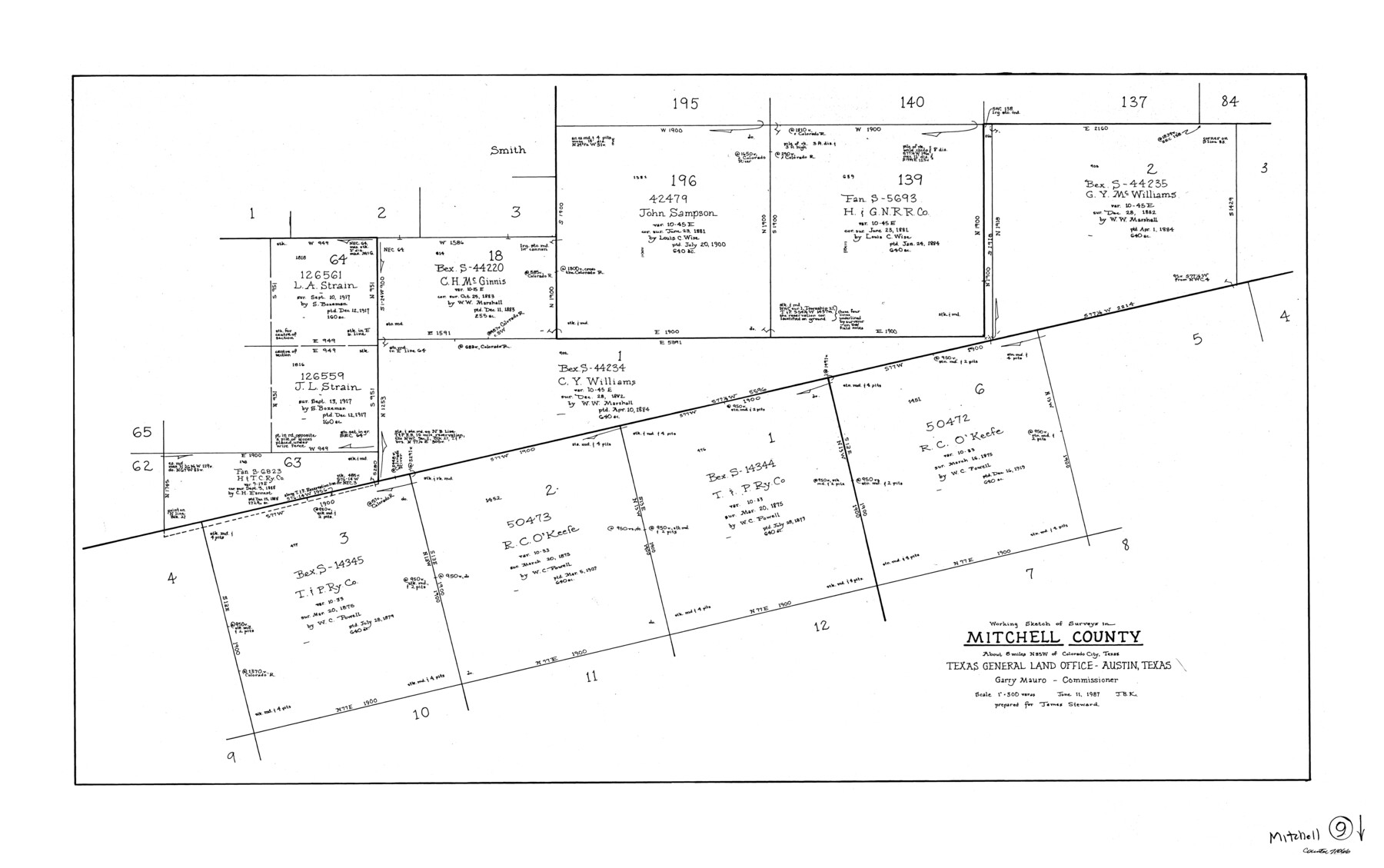
Mitchell County Working Sketch 9
-
Map/Doc
71066
-
Collection
General Map Collection
-
Object Dates
6/11/1987 (Creation Date)
-
People and Organizations
Joan Kilpatrick (Draftsman)
-
Counties
Mitchell
-
Subjects
Surveying Working Sketch
-
Height x Width
25.8 x 41.1 inches
65.5 x 104.4 cm
-
Scale
1" = 300 varas
Part of: General Map Collection
Map of Runnels County

Print $20.00
- Digital $50.00
Map of Runnels County
1858
Size 24.7 x 25.6 inches
Map/Doc 4004
Stephens County Working Sketch 12

Print $20.00
- Digital $50.00
Stephens County Working Sketch 12
1947
Size 20.9 x 22.2 inches
Map/Doc 63955
Map of Bandera County

Print $20.00
- Digital $50.00
Map of Bandera County
1878
Size 19.3 x 29.4 inches
Map/Doc 3272
La Salle County Rolled Sketch 17

Print $20.00
- Digital $50.00
La Salle County Rolled Sketch 17
Size 26.5 x 29.9 inches
Map/Doc 6581
Map of Falls County

Print $20.00
- Digital $50.00
Map of Falls County
1855
Size 21.4 x 23.9 inches
Map/Doc 3532
Flight Mission No. BRA-16M, Frame 85, Jefferson County

Print $20.00
- Digital $50.00
Flight Mission No. BRA-16M, Frame 85, Jefferson County
1953
Size 18.6 x 22.4 inches
Map/Doc 85697
McMullen County Working Sketch 26

Print $20.00
- Digital $50.00
McMullen County Working Sketch 26
1953
Size 17.8 x 14.5 inches
Map/Doc 70727
Uvalde County Sketch File 8

Print $6.00
- Digital $50.00
Uvalde County Sketch File 8
1882
Size 8.4 x 6.2 inches
Map/Doc 38964
Supreme Court of the United States, October Term, 1924, No. 13, Original - The State of Oklahoma, Complainant vs. The State of Texas, Defendant, The United States, Intervener

Print $20.00
- Digital $50.00
Supreme Court of the United States, October Term, 1924, No. 13, Original - The State of Oklahoma, Complainant vs. The State of Texas, Defendant, The United States, Intervener
1924
Size 19.5 x 32.6 inches
Map/Doc 75112
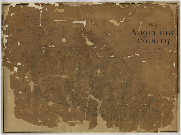
Map of Angelina County
Print $40.00
- Digital $50.00
Map of Angelina County
1899
Size 39.1 x 52.3 inches
Map/Doc 4777
Flight Mission No. DQN-1K, Frame 136, Calhoun County

Print $20.00
- Digital $50.00
Flight Mission No. DQN-1K, Frame 136, Calhoun County
1953
Size 18.5 x 22.3 inches
Map/Doc 84199
Jackson County Rolled Sketch 10

Print $20.00
- Digital $50.00
Jackson County Rolled Sketch 10
1941
Size 47.1 x 32.5 inches
Map/Doc 9259
You may also like
Matagorda County Rolled Sketch 9

Print $20.00
- Digital $50.00
Matagorda County Rolled Sketch 9
Size 36.8 x 30.0 inches
Map/Doc 6680

Brewster County Rolled Sketch 114

Print $20.00
- Digital $50.00
Brewster County Rolled Sketch 114
1964
Size 11.9 x 18.3 inches
Map/Doc 5280
Wichita County

Print $20.00
- Digital $50.00
Wichita County
1971
Size 35.8 x 37.7 inches
Map/Doc 77457
Flight Mission No. DCL-7C, Frame 111, Kenedy County

Print $20.00
- Digital $50.00
Flight Mission No. DCL-7C, Frame 111, Kenedy County
1943
Size 18.5 x 22.3 inches
Map/Doc 86076
Real County Working Sketch 59

Print $20.00
- Digital $50.00
Real County Working Sketch 59
1962
Size 27.4 x 40.7 inches
Map/Doc 71951
Dallas County Boundary File 1

Print $62.00
- Digital $50.00
Dallas County Boundary File 1
Size 4.1 x 3.7 inches
Map/Doc 52084
Copy of a chart of Aransas and Corpus Christi Bays by an inhabitant of St. Joseph's Island, the main features of which have been verified by the actual examination of myself & other officers of the Army

Print $20.00
- Digital $50.00
Copy of a chart of Aransas and Corpus Christi Bays by an inhabitant of St. Joseph's Island, the main features of which have been verified by the actual examination of myself & other officers of the Army
1846
Size 26.6 x 18.3 inches
Map/Doc 72972
[Scurry County]
![63030, [Scurry County], General Map Collection](https://historictexasmaps.com/wmedia_w700/maps/63030.tif.jpg)
Print $20.00
- Digital $50.00
[Scurry County]
1901
Size 34.3 x 42.5 inches
Map/Doc 63030
Val Verde County Rolled Sketch 45

Print $20.00
- Digital $50.00
Val Verde County Rolled Sketch 45
Size 20.8 x 23.1 inches
Map/Doc 8118
Tom Green County Rolled Sketch 23

Print $20.00
- Digital $50.00
Tom Green County Rolled Sketch 23
Size 19.1 x 21.9 inches
Map/Doc 8005
Hardeman County Working Sketch 13

Print $20.00
- Digital $50.00
Hardeman County Working Sketch 13
1966
Size 35.8 x 45.7 inches
Map/Doc 63394