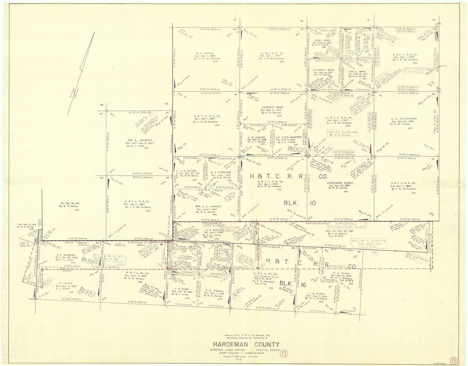
Hardeman County Working Sketch 13
-
Map/Doc
63394
-
Collection
General Map Collection
-
Object Dates
4/4/1966 (Creation Date)
-
People and Organizations
Roy Buckholts (Draftsman)
-
Counties
Hardeman
-
Subjects
Surveying Working Sketch
-
Height x Width
35.8 x 45.7 inches
90.9 x 116.1 cm
-
Scale
1" = 300 varas
Part of: General Map Collection
Galveston County Sketch File 73g

Print $20.00
- Digital $50.00
Galveston County Sketch File 73g
Size 32.1 x 41.2 inches
Map/Doc 10460
Kendall County Rolled Sketch 4

Print $20.00
- Digital $50.00
Kendall County Rolled Sketch 4
1945
Size 29.9 x 27.0 inches
Map/Doc 6457
Wichita County Sketch File 8

Print $4.00
- Digital $50.00
Wichita County Sketch File 8
1860
Size 11.7 x 8.2 inches
Map/Doc 40048
Terry County Working Sketch Graphic Index

Print $20.00
- Digital $50.00
Terry County Working Sketch Graphic Index
1970
Size 41.2 x 33.8 inches
Map/Doc 76712
Hardin County Working Sketch 28

Print $20.00
- Digital $50.00
Hardin County Working Sketch 28
1956
Size 18.8 x 18.9 inches
Map/Doc 63426
Map of Goliad County Texas

Print $20.00
- Digital $50.00
Map of Goliad County Texas
1879
Size 19.5 x 21.8 inches
Map/Doc 4548
Webb County Sketch File 19

Print $15.00
- Digital $50.00
Webb County Sketch File 19
1902
Size 9.2 x 17.0 inches
Map/Doc 39822
Coleman County Sketch File 49

Print $80.00
- Digital $50.00
Coleman County Sketch File 49
1918
Size 14.2 x 8.6 inches
Map/Doc 18813
Menard County Rolled Sketch 15

Print $20.00
- Digital $50.00
Menard County Rolled Sketch 15
1983
Size 27.9 x 22.0 inches
Map/Doc 6761
Northwest Part Crockett County

Print $20.00
- Digital $50.00
Northwest Part Crockett County
1983
Size 29.9 x 39.1 inches
Map/Doc 77252
Flight Mission No. BRA-8M, Frame 74, Jefferson County

Print $20.00
- Digital $50.00
Flight Mission No. BRA-8M, Frame 74, Jefferson County
1953
Size 18.6 x 22.2 inches
Map/Doc 85594
Panola County Rolled Sketch 6

Print $40.00
- Digital $50.00
Panola County Rolled Sketch 6
1956
Size 26.0 x 55.7 inches
Map/Doc 9679
You may also like
Harris County Sketch File 55

Print $20.00
- Digital $50.00
Harris County Sketch File 55
1916
Size 21.8 x 29.7 inches
Map/Doc 11655
Sketch Showing Property Lines of Harlem State Farm

Print $20.00
- Digital $50.00
Sketch Showing Property Lines of Harlem State Farm
Size 16.0 x 30.2 inches
Map/Doc 62982
Shackelford County Rolled Sketch 4

Print $20.00
- Digital $50.00
Shackelford County Rolled Sketch 4
Size 38.8 x 47.7 inches
Map/Doc 9916
Plano General de los Ferrocarriles Nacionales de Mexico, F.C. Internacional Mexicano, F.C. Interoceanico de Mexico, F.C. Mexicano del sur y sus Conexiones

Print $20.00
- Digital $50.00
Plano General de los Ferrocarriles Nacionales de Mexico, F.C. Internacional Mexicano, F.C. Interoceanico de Mexico, F.C. Mexicano del sur y sus Conexiones
Size 27.8 x 32.5 inches
Map/Doc 95743
Parmer County Sketch File 3

Print $20.00
- Digital $50.00
Parmer County Sketch File 3
1905
Size 17.2 x 14.4 inches
Map/Doc 12153
Nautical Chart 887-SC Intracoastal Waterway - Galveston Bay to Cedar Lakes including the Brazos and San Bernard Rivers, Texas

Print $40.00
- Digital $50.00
Nautical Chart 887-SC Intracoastal Waterway - Galveston Bay to Cedar Lakes including the Brazos and San Bernard Rivers, Texas
1971
Size 15.7 x 59.5 inches
Map/Doc 69938
Murphy and Bolanz' Index Map of Greater Dallas

Print $20.00
- Digital $50.00
Murphy and Bolanz' Index Map of Greater Dallas
1911
Size 20.3 x 18.3 inches
Map/Doc 96794
[Block RG, Block C, San Augustine School Land]
![92863, [Block RG, Block C, San Augustine School Land], Twichell Survey Records](https://historictexasmaps.com/wmedia_w700/maps/92863-1.tif.jpg)
Print $20.00
- Digital $50.00
[Block RG, Block C, San Augustine School Land]
Size 32.8 x 38.7 inches
Map/Doc 92863
Kinney County Sketch File 32

Print $6.00
- Digital $50.00
Kinney County Sketch File 32
1934
Size 11.2 x 8.8 inches
Map/Doc 29178
The Republic County of Montgomery. January 25, 1840

Print $20.00
The Republic County of Montgomery. January 25, 1840
2020
Size 19.9 x 21.7 inches
Map/Doc 96237
Map of the CB Live Stock Co. -N- Ranch situated in Crosby County, Texas

Print $20.00
- Digital $50.00
Map of the CB Live Stock Co. -N- Ranch situated in Crosby County, Texas
1907
Size 41.4 x 38.0 inches
Map/Doc 89919
Flight Mission No. CRC-3R, Frame 9, Chambers County

Print $20.00
- Digital $50.00
Flight Mission No. CRC-3R, Frame 9, Chambers County
1956
Size 18.7 x 22.4 inches
Map/Doc 84783