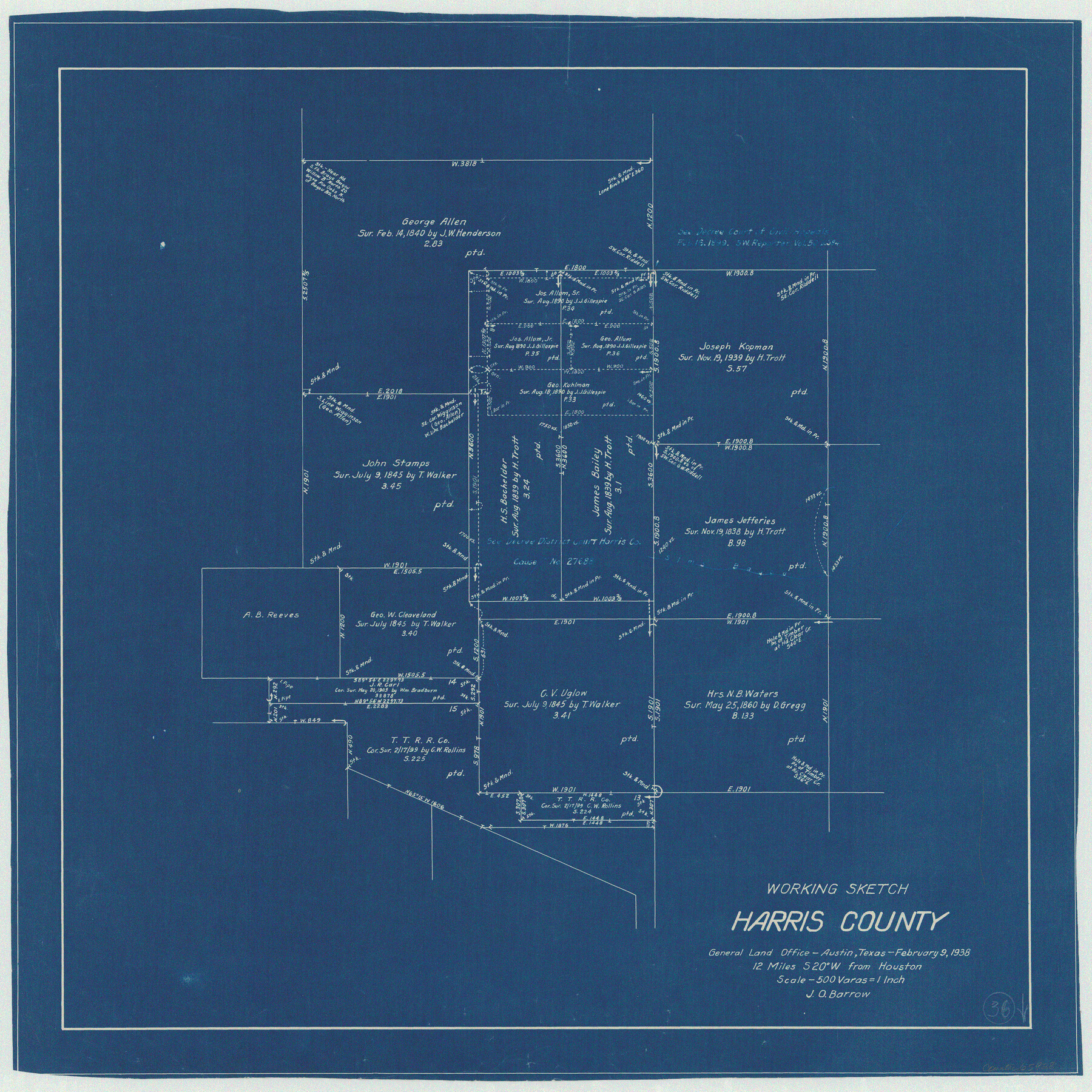
Harris County Working Sketch 36
-
Map/Doc
65928
-
Collection
General Map Collection
-
Object Dates
2/9/1938 (Creation Date)
-
People and Organizations
J.O. Barrow (Draftsman)
-
Counties
Harris
-
Subjects
Surveying Working Sketch
-
Height x Width
23.8 x 23.8 inches
60.5 x 60.5 cm
-
Scale
1" = 500 varas
Part of: General Map Collection
Brown County Sketch File 31

Print $6.00
- Digital $50.00
Brown County Sketch File 31
Size 17.0 x 11.0 inches
Map/Doc 16643
Hudspeth County Rolled Sketch 63

Print $20.00
- Digital $50.00
Hudspeth County Rolled Sketch 63
Size 41.8 x 47.9 inches
Map/Doc 9227
Right of Way and Track Map, Dayton-Goose Creek Ry. Co., Station 190+00 to Station 401+20

Print $40.00
- Digital $50.00
Right of Way and Track Map, Dayton-Goose Creek Ry. Co., Station 190+00 to Station 401+20
1917
Size 25.4 x 56.8 inches
Map/Doc 64366
Brewster County Working Sketch 63

Print $20.00
- Digital $50.00
Brewster County Working Sketch 63
1956
Size 30.4 x 28.9 inches
Map/Doc 67664
Culberson County Sketch File 26

Print $8.00
- Digital $50.00
Culberson County Sketch File 26
1949
Size 11.2 x 8.8 inches
Map/Doc 20262
Moore County Working Sketch 6

Print $20.00
- Digital $50.00
Moore County Working Sketch 6
1921
Size 16.0 x 14.5 inches
Map/Doc 71188
Hardeman County Sketch File 7

Print $10.00
- Digital $50.00
Hardeman County Sketch File 7
Size 8.9 x 14.1 inches
Map/Doc 24997
Victoria County Sketch File 5

Print $4.00
- Digital $50.00
Victoria County Sketch File 5
1877
Size 14.5 x 8.8 inches
Map/Doc 39520
Blucher's Directory Map of Corpus Christi and Road Map of Nueces County

Print $20.00
- Digital $50.00
Blucher's Directory Map of Corpus Christi and Road Map of Nueces County
1945
Size 22.7 x 34.4 inches
Map/Doc 94105
Duval County Sketch File 47

Print $6.00
- Digital $50.00
Duval County Sketch File 47
Size 11.5 x 8.8 inches
Map/Doc 21402
Flight Mission No. CRC-2R, Frame 55, Chambers County

Print $20.00
- Digital $50.00
Flight Mission No. CRC-2R, Frame 55, Chambers County
1956
Size 18.7 x 22.4 inches
Map/Doc 84728
Lynn County Rolled Sketch W

Print $20.00
- Digital $50.00
Lynn County Rolled Sketch W
Size 23.0 x 40.0 inches
Map/Doc 6655
You may also like
Harbor Pass and Bar at Brazos Santiago, Texas

Print $20.00
- Digital $50.00
Harbor Pass and Bar at Brazos Santiago, Texas
1879
Size 18.2 x 27.5 inches
Map/Doc 73000
Map of Houston, Harris County, Texas

Print $20.00
- Digital $50.00
Map of Houston, Harris County, Texas
1900
Size 38.5 x 32.0 inches
Map/Doc 93390
Working Sketch in Stephens-Palo Pinto Cos.

Print $20.00
- Digital $50.00
Working Sketch in Stephens-Palo Pinto Cos.
1919
Size 22.3 x 13.3 inches
Map/Doc 91918
Houston County Working Sketch 25

Print $40.00
- Digital $50.00
Houston County Working Sketch 25
1983
Size 43.6 x 89.0 inches
Map/Doc 66255
Karnes County Sketch File 4

Print $8.00
- Digital $50.00
Karnes County Sketch File 4
1852
Size 5.5 x 6.8 inches
Map/Doc 28550
La Salle County Sketch File 19 1/2

Print $28.00
- Digital $50.00
La Salle County Sketch File 19 1/2
1886
Size 14.3 x 8.7 inches
Map/Doc 29515
Houston County Working Sketch 18

Print $20.00
- Digital $50.00
Houston County Working Sketch 18
Size 18.8 x 22.5 inches
Map/Doc 66248
Cass County Working Sketch 6

Print $20.00
- Digital $50.00
Cass County Working Sketch 6
1936
Size 19.7 x 23.0 inches
Map/Doc 67909
Texas (verso)

Print $20.00
- Digital $50.00
Texas (verso)
1833
Size 19.1 x 22.8 inches
Map/Doc 93837
Lubbock County Sketch File 15

Print $6.00
- Digital $50.00
Lubbock County Sketch File 15
1902
Size 11.2 x 8.8 inches
Map/Doc 30440
Flight Mission No. CRC-3R, Frame 27, Chambers County

Print $20.00
- Digital $50.00
Flight Mission No. CRC-3R, Frame 27, Chambers County
1956
Size 18.7 x 22.3 inches
Map/Doc 84801
[Worksheets related to the Wilson Strickland survey and vicinity]
![91381, [Worksheets related to the Wilson Strickland survey and vicinity], Twichell Survey Records](https://historictexasmaps.com/wmedia_w700/maps/91381-1.tif.jpg)
Print $20.00
- Digital $50.00
[Worksheets related to the Wilson Strickland survey and vicinity]
Size 20.1 x 24.8 inches
Map/Doc 91381