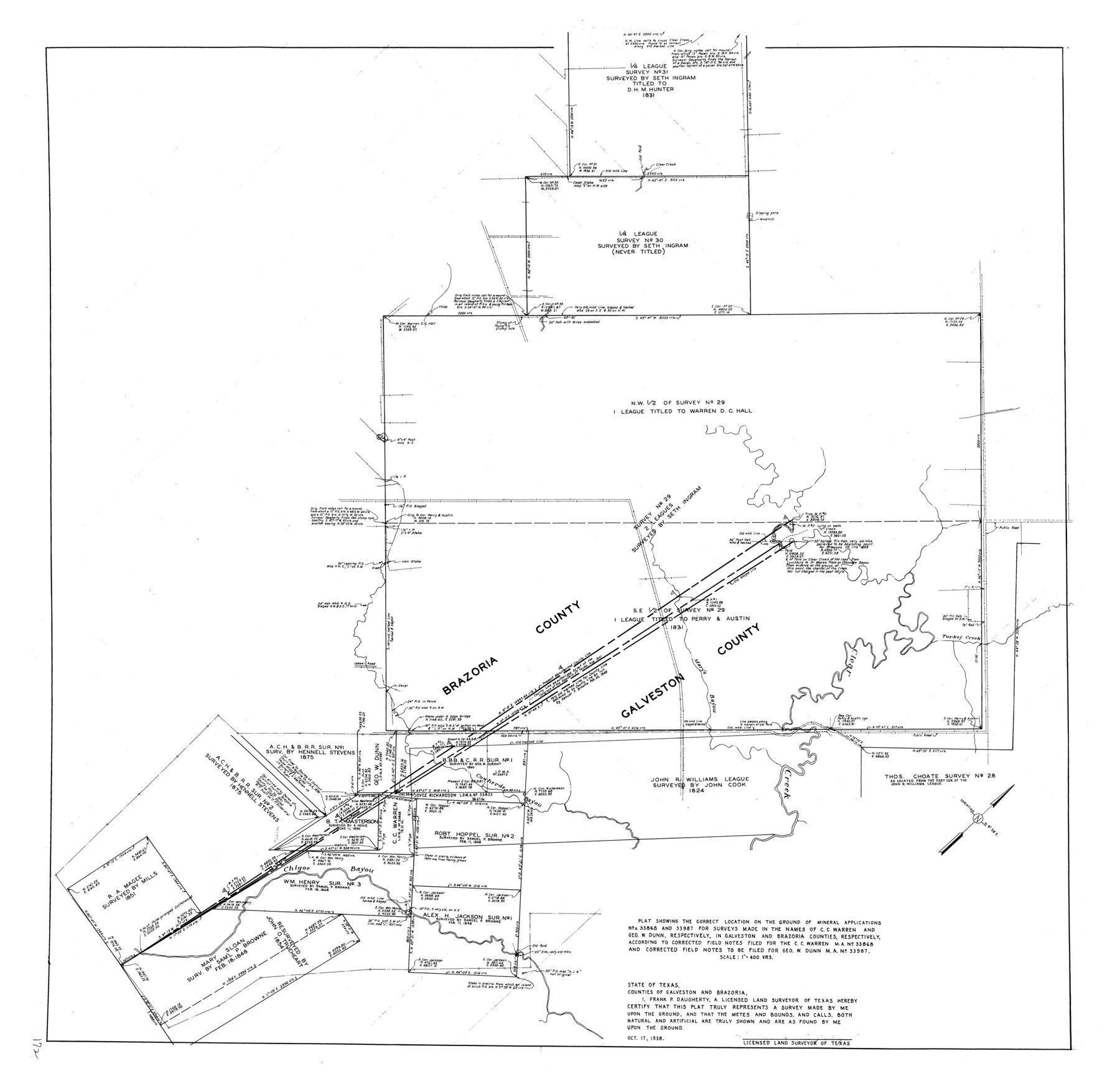
Galveston County Rolled Sketch CCW
Plat showing the correct location on the ground of Mineral Applications Nos. 33868 and 33987 for surveys made in the name of C.C. Warren and Geo. W. Dunn, respectively, in Galveston and Brazoria Counties, respectively
-
Map/Doc
9084
-
Collection
General Map Collection
-
Object Dates
1938/10/20 (File Date)
1938/10/17 (Creation Date)
-
People and Organizations
Frank P. Daugherty (Surveyor/Engineer)
-
Counties
Galveston Brazoria
-
Subjects
Surveying Rolled Sketch
-
Height x Width
38.4 x 39.7 inches
97.5 x 100.8 cm
-
Scale
1" = 400 varas
Part of: General Map Collection
El Paso County Rolled Sketch 40

Print $20.00
- Digital $50.00
El Paso County Rolled Sketch 40
1930
Size 11.6 x 16.8 inches
Map/Doc 5826
Coleman County Working Sketch 2

Print $20.00
- Digital $50.00
Coleman County Working Sketch 2
1917
Size 15.0 x 16.8 inches
Map/Doc 68068
Red River County Sketch File 26

Print $4.00
- Digital $50.00
Red River County Sketch File 26
Size 14.7 x 7.9 inches
Map/Doc 35161
Kimble County Sketch File L1

Print $22.00
- Digital $50.00
Kimble County Sketch File L1
Size 7.1 x 13.1 inches
Map/Doc 28967
Brewster County Rolled Sketch 134

Print $20.00
- Digital $50.00
Brewster County Rolled Sketch 134
Size 19.0 x 24.9 inches
Map/Doc 5303
Map of the City of Austin Texas

Map of the City of Austin Texas
1933
Size 22.5 x 17.6 inches
Map/Doc 76050
Concho County Rolled Sketch 20

Print $20.00
- Digital $50.00
Concho County Rolled Sketch 20
1968
Size 26.2 x 38.8 inches
Map/Doc 5554
Pecos County Working Sketch 85

Print $20.00
- Digital $50.00
Pecos County Working Sketch 85
1962
Size 45.4 x 35.7 inches
Map/Doc 71557
Donley County Boundary File 5

Print $4.00
- Digital $50.00
Donley County Boundary File 5
Size 11.2 x 8.8 inches
Map/Doc 52635
Galveston County Rolled Sketch 14

Print $155.00
- Digital $50.00
Galveston County Rolled Sketch 14
1950
Size 10.1 x 15.3 inches
Map/Doc 44808
Crane County Working Sketch 4

Print $20.00
- Digital $50.00
Crane County Working Sketch 4
Size 24.5 x 18.2 inches
Map/Doc 68281
Kendall County Working Sketch 13

Print $20.00
- Digital $50.00
Kendall County Working Sketch 13
1959
Size 25.5 x 30.5 inches
Map/Doc 66685
You may also like
Jefferson County Sketch File 48

Print $20.00
- Digital $50.00
Jefferson County Sketch File 48
1875
Size 19.8 x 21.0 inches
Map/Doc 11882
Galveston County Sketch File 68

Print $62.00
- Digital $50.00
Galveston County Sketch File 68
Size 4.4 x 9.7 inches
Map/Doc 23784
[Right of Way & Track Map, The Texas & Pacific Ry. Co. Main Line]
![64675, [Right of Way & Track Map, The Texas & Pacific Ry. Co. Main Line], General Map Collection](https://historictexasmaps.com/wmedia_w700/maps/64675.tif.jpg)
Print $20.00
- Digital $50.00
[Right of Way & Track Map, The Texas & Pacific Ry. Co. Main Line]
Size 11.0 x 18.4 inches
Map/Doc 64675
Flight Mission No. BRE-2P, Frame 101, Nueces County

Print $20.00
- Digital $50.00
Flight Mission No. BRE-2P, Frame 101, Nueces County
1956
Size 18.4 x 22.2 inches
Map/Doc 86786
Caldwell County Sketch File 2

Print $40.00
- Digital $50.00
Caldwell County Sketch File 2
1877
Size 12.9 x 20.0 inches
Map/Doc 11030
Randall County Rolled Sketch 3

Print $20.00
- Digital $50.00
Randall County Rolled Sketch 3
Size 22.0 x 24.9 inches
Map/Doc 7423
Red River County Rolled Sketch 11

Print $40.00
- Digital $50.00
Red River County Rolled Sketch 11
2006
Size 36.8 x 48.6 inches
Map/Doc 88614
Leon River, Leon River Sheet No. 1

Print $4.00
- Digital $50.00
Leon River, Leon River Sheet No. 1
1936
Size 29.2 x 19.8 inches
Map/Doc 65067
Presidio County Working Sketch 37

Print $20.00
- Digital $50.00
Presidio County Working Sketch 37
1948
Size 26.9 x 43.3 inches
Map/Doc 71714
Jalisco Banco Number 67, cut from Mexico in 1909

Print $3.00
- Digital $50.00
Jalisco Banco Number 67, cut from Mexico in 1909
1912
Size 14.2 x 11.2 inches
Map/Doc 2064
Flight Mission No. CRC-5R, Frame 18, Chambers County

Print $20.00
- Digital $50.00
Flight Mission No. CRC-5R, Frame 18, Chambers County
1956
Size 18.7 x 22.4 inches
Map/Doc 84940
Taylor County Sketch File 4

Print $2.00
- Digital $50.00
Taylor County Sketch File 4
Size 7.2 x 9.8 inches
Map/Doc 37780