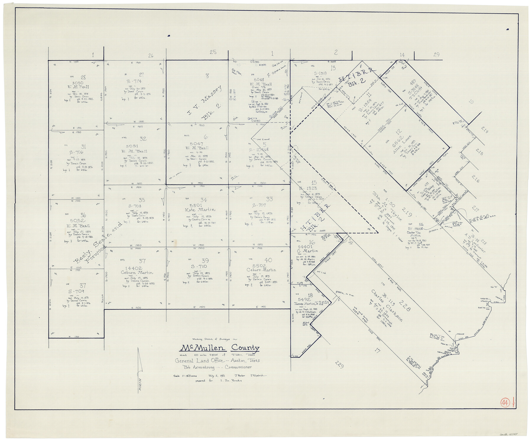
McMullen County Working Sketch 44
-
Map/Doc
70745
-
Collection
General Map Collection
-
Object Dates
7/2/1981 (Creation Date)
-
People and Organizations
Joan Kilpatrick (Draftsman)
-
Counties
McMullen
-
Subjects
Surveying Working Sketch
-
Height x Width
35.1 x 41.2 inches
89.2 x 104.7 cm
-
Scale
1" = 400 varas
Part of: General Map Collection
Kimble County Working Sketch 64

Print $20.00
- Digital $50.00
Kimble County Working Sketch 64
1964
Size 15.1 x 16.9 inches
Map/Doc 70132
San Luis Pass to East Matagorda Bay

Print $20.00
- Digital $50.00
San Luis Pass to East Matagorda Bay
1964
Size 34.7 x 46.6 inches
Map/Doc 69964
Pecos County Rolled Sketch 81

Print $20.00
- Digital $50.00
Pecos County Rolled Sketch 81
1930
Size 35.9 x 25.4 inches
Map/Doc 7240
Roberts County Sketch File 1

Print $20.00
- Digital $50.00
Roberts County Sketch File 1
Size 39.2 x 22.3 inches
Map/Doc 10589
[Sketch for Mineral Application 24072, San Jacinto River]
![65599, [Sketch for Mineral Application 24072, San Jacinto River], General Map Collection](https://historictexasmaps.com/wmedia_w700/maps/65599.tif.jpg)
Print $20.00
- Digital $50.00
[Sketch for Mineral Application 24072, San Jacinto River]
1929
Size 23.5 x 18.0 inches
Map/Doc 65599
Marion County Working Sketch 14

Print $20.00
- Digital $50.00
Marion County Working Sketch 14
1956
Size 25.1 x 25.0 inches
Map/Doc 70790
San Patricio County Rolled Sketch 48

Print $20.00
- Digital $50.00
San Patricio County Rolled Sketch 48
1984
Size 37.0 x 25.6 inches
Map/Doc 7733
Flight Mission No. CUG-1P, Frame 54, Kleberg County

Print $20.00
- Digital $50.00
Flight Mission No. CUG-1P, Frame 54, Kleberg County
1956
Size 18.5 x 22.3 inches
Map/Doc 86132
Loving County Working Sketch 2

Print $20.00
- Digital $50.00
Loving County Working Sketch 2
1937
Size 33.9 x 42.5 inches
Map/Doc 70634
Jones County Sketch File 15

Print $40.00
- Digital $50.00
Jones County Sketch File 15
1892
Size 13.7 x 16.3 inches
Map/Doc 28503
Sabine Pass and Lake

Print $20.00
- Digital $50.00
Sabine Pass and Lake
1971
Size 47.0 x 27.5 inches
Map/Doc 69825
Haskell County Working Sketch 10

Print $20.00
- Digital $50.00
Haskell County Working Sketch 10
1961
Size 26.8 x 20.4 inches
Map/Doc 66068
You may also like
Right of Way and Track Map, Dayton-Goose Creek Ry. Co., Station 0+00 to Station 190+00

Print $40.00
- Digital $50.00
Right of Way and Track Map, Dayton-Goose Creek Ry. Co., Station 0+00 to Station 190+00
1917
Size 24.8 x 56.6 inches
Map/Doc 64365

Map of the Houston & Texas Central Railway and connections

Print $20.00
- Digital $50.00
Map of the Houston & Texas Central Railway and connections
1871
Size 16.6 x 15.4 inches
Map/Doc 95753
Rhyne Simpson Addition City of Lubbock Section 3, Block O

Print $20.00
- Digital $50.00
Rhyne Simpson Addition City of Lubbock Section 3, Block O
1951
Size 18.2 x 23.4 inches
Map/Doc 92845
Working Sketch of Surveys in Presidio County in the area east of Shafter, Texas

Print $20.00
- Digital $50.00
Working Sketch of Surveys in Presidio County in the area east of Shafter, Texas
1947
Size 37.5 x 40.1 inches
Map/Doc 89889
Engineer's Office, Department of the Gulf Map No. 59, Texas prepared by order of Maj. Gen. N. P. Banks under direction of Capt. P. C. Hains, U. S. Engr. & Chief Engr., Dept. of the Gulf

Print $20.00
- Digital $50.00
Engineer's Office, Department of the Gulf Map No. 59, Texas prepared by order of Maj. Gen. N. P. Banks under direction of Capt. P. C. Hains, U. S. Engr. & Chief Engr., Dept. of the Gulf
1865
Size 18.2 x 27.5 inches
Map/Doc 72718
Foard County Sketch File 32

Print $4.00
- Digital $50.00
Foard County Sketch File 32
1950
Size 14.5 x 9.0 inches
Map/Doc 22864
Travis County Appraisal District Plat Map 2_0219

Print $20.00
- Digital $50.00
Travis County Appraisal District Plat Map 2_0219
Size 21.6 x 26.5 inches
Map/Doc 94209
Brown County Sketch File 30

Print $27.00
- Digital $50.00
Brown County Sketch File 30
1924
Size 12.7 x 11.0 inches
Map/Doc 16631
Flight Mission No. BRA-3M, Frame 123, Jefferson County

Print $20.00
- Digital $50.00
Flight Mission No. BRA-3M, Frame 123, Jefferson County
1953
Size 18.5 x 21.7 inches
Map/Doc 85397
Jefferson County Sketch File 26a

Print $20.00
- Digital $50.00
Jefferson County Sketch File 26a
Size 19.5 x 11.6 inches
Map/Doc 11872
Angelina County Working Sketch 53

Print $40.00
- Digital $50.00
Angelina County Working Sketch 53
1988
Size 42.9 x 58.5 inches
Map/Doc 67137