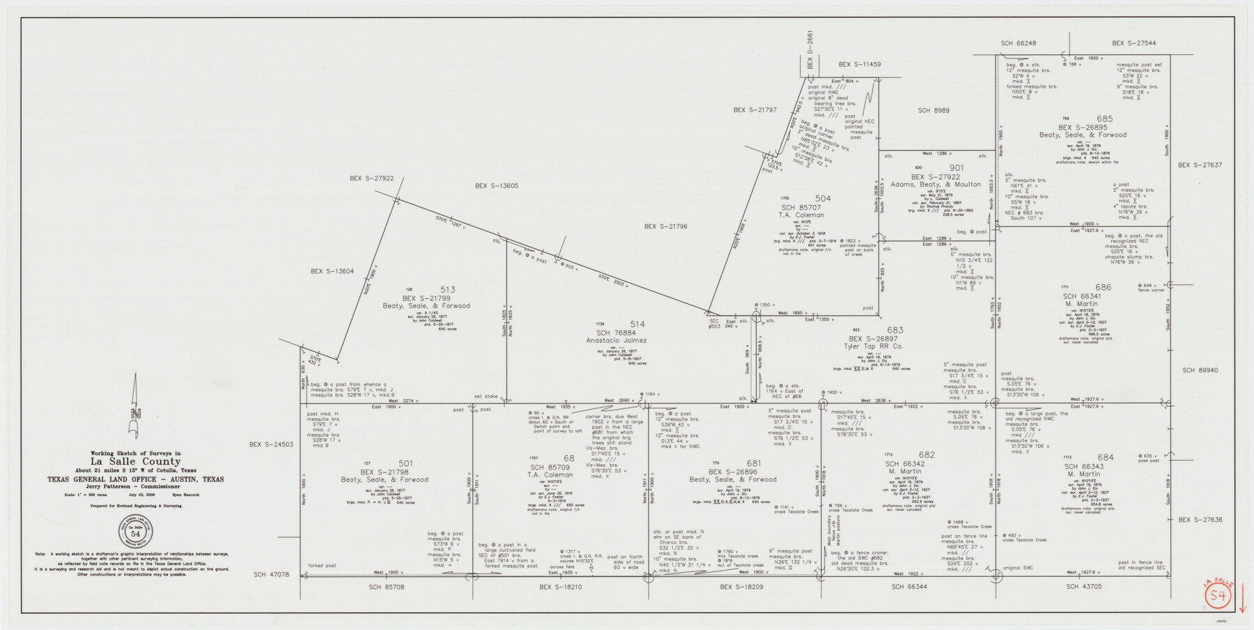
La Salle County Working Sketch 54
-
Map/Doc
89048
-
Collection
General Map Collection
-
Object Dates
7/23/2009 (Creation Date)
-
People and Organizations
Jerry E. Patterson (GLO Commissioner)
Ryan Hancock (Draftsman)
-
Counties
La Salle
-
Subjects
Surveying Working Sketch
-
Height x Width
23.2 x 46.2 inches
58.9 x 117.4 cm
-
Scale
1" = 300 varas
Part of: General Map Collection
Kimble County Working Sketch 46

Print $20.00
- Digital $50.00
Kimble County Working Sketch 46
1951
Size 29.3 x 18.9 inches
Map/Doc 70114
Jeff Davis County Working Sketch 23

Print $20.00
- Digital $50.00
Jeff Davis County Working Sketch 23
1958
Size 41.5 x 30.7 inches
Map/Doc 66518
Pecos County Sketch File 119

Print $6.00
- Digital $50.00
Pecos County Sketch File 119
1925
Size 11.2 x 8.8 inches
Map/Doc 34111
Outer Continental Shelf Leasing Maps (Louisiana Offshore Operations)

Print $20.00
- Digital $50.00
Outer Continental Shelf Leasing Maps (Louisiana Offshore Operations)
1955
Size 10.3 x 11.6 inches
Map/Doc 76088
Jeff Davis County Sketch File 2a

Print $4.00
- Digital $50.00
Jeff Davis County Sketch File 2a
Size 8.3 x 3.3 inches
Map/Doc 27890
Glasscock County

Print $20.00
- Digital $50.00
Glasscock County
1899
Size 38.1 x 33.9 inches
Map/Doc 4707
Galveston County Rolled Sketch 16

Print $20.00
- Digital $50.00
Galveston County Rolled Sketch 16
1952
Size 43.6 x 38.0 inches
Map/Doc 9078
Erath County Working Sketch 21

Print $20.00
- Digital $50.00
Erath County Working Sketch 21
1965
Size 23.9 x 19.8 inches
Map/Doc 69102
Jefferson County Rolled Sketch 21

Print $20.00
- Digital $50.00
Jefferson County Rolled Sketch 21
Size 12.0 x 12.1 inches
Map/Doc 6387
Blanco County Sketch File 26

Print $40.00
- Digital $50.00
Blanco County Sketch File 26
1888
Size 14.1 x 17.2 inches
Map/Doc 14618
Map Shelby County

Print $20.00
- Digital $50.00
Map Shelby County
1852
Size 20.1 x 31.5 inches
Map/Doc 4029
Cass County Working Sketch 23

Print $40.00
- Digital $50.00
Cass County Working Sketch 23
1966
Size 56.8 x 37.1 inches
Map/Doc 67926
You may also like
Texas Land Commissioner Jerry Patterson's Great Military Map of Texas showing Significant Conflicts and Events between 1685 and 1916

Print $20.00
- Digital $50.00
Texas Land Commissioner Jerry Patterson's Great Military Map of Texas showing Significant Conflicts and Events between 1685 and 1916
2006
Size 36.7 x 24.8 inches
Map/Doc 83432
Map of Dallas & Greenville Railroad through Dallas County, Texas

Print $2.00
- Digital $50.00
Map of Dallas & Greenville Railroad through Dallas County, Texas
Size 14.8 x 4.5 inches
Map/Doc 64487
The Republic County of Red River. January 28, 1841

Print $20.00
The Republic County of Red River. January 28, 1841
2020
Size 21.0 x 21.7 inches
Map/Doc 96253
Map of Shelby County

Print $20.00
- Digital $50.00
Map of Shelby County
1839
Size 24.5 x 25.7 inches
Map/Doc 4032
Motley County Sketch File DD (S)

Print $22.00
- Digital $50.00
Motley County Sketch File DD (S)
Size 10.9 x 7.1 inches
Map/Doc 32159
[League in the South Part of Lamb County]
![91052, [League in the South Part of Lamb County], Twichell Survey Records](https://historictexasmaps.com/wmedia_w700/maps/91052-1.tif.jpg)
Print $20.00
- Digital $50.00
[League in the South Part of Lamb County]
Size 30.4 x 34.1 inches
Map/Doc 91052
PSL Field Notes for Block C24 in Loving and Winkler Counties, and Blocks C25, C26, and C27 in Loving County

PSL Field Notes for Block C24 in Loving and Winkler Counties, and Blocks C25, C26, and C27 in Loving County
Map/Doc 81680
[Map 1:] A Geographically Correct County Map of States Traversed by the St. Louis, Iron Mountain and Southern Railway and its connections / [Map 2:] Map of the St. Louis, Iron Mountain and Southern Railway, and connections
![95784, [Map 1:] A Geographically Correct County Map of States Traversed by the St. Louis, Iron Mountain and Southern Railway and its connections / [Map 2:] Map of the St. Louis, Iron Mountain and Southern Railway, and connections, Cobb Digital Map Collection - 1](https://historictexasmaps.com/wmedia_w700/maps/95784.tif.jpg)
Print $20.00
- Digital $50.00
[Map 1:] A Geographically Correct County Map of States Traversed by the St. Louis, Iron Mountain and Southern Railway and its connections / [Map 2:] Map of the St. Louis, Iron Mountain and Southern Railway, and connections
1878
Size 18.9 x 32.2 inches
Map/Doc 95784
Harris County Historic Topographic 2

Print $20.00
- Digital $50.00
Harris County Historic Topographic 2
1916
Size 29.5 x 22.7 inches
Map/Doc 65812
Bosque County

Print $20.00
- Digital $50.00
Bosque County
1945
Size 42.6 x 33.0 inches
Map/Doc 77215
Flight Mission No. DAH-9M, Frame 165, Orange County

Print $20.00
- Digital $50.00
Flight Mission No. DAH-9M, Frame 165, Orange County
1953
Size 18.5 x 22.3 inches
Map/Doc 86864
Flight Mission No. DQO-7K, Frame 104, Galveston County

Print $20.00
- Digital $50.00
Flight Mission No. DQO-7K, Frame 104, Galveston County
1952
Size 18.7 x 22.4 inches
Map/Doc 85119