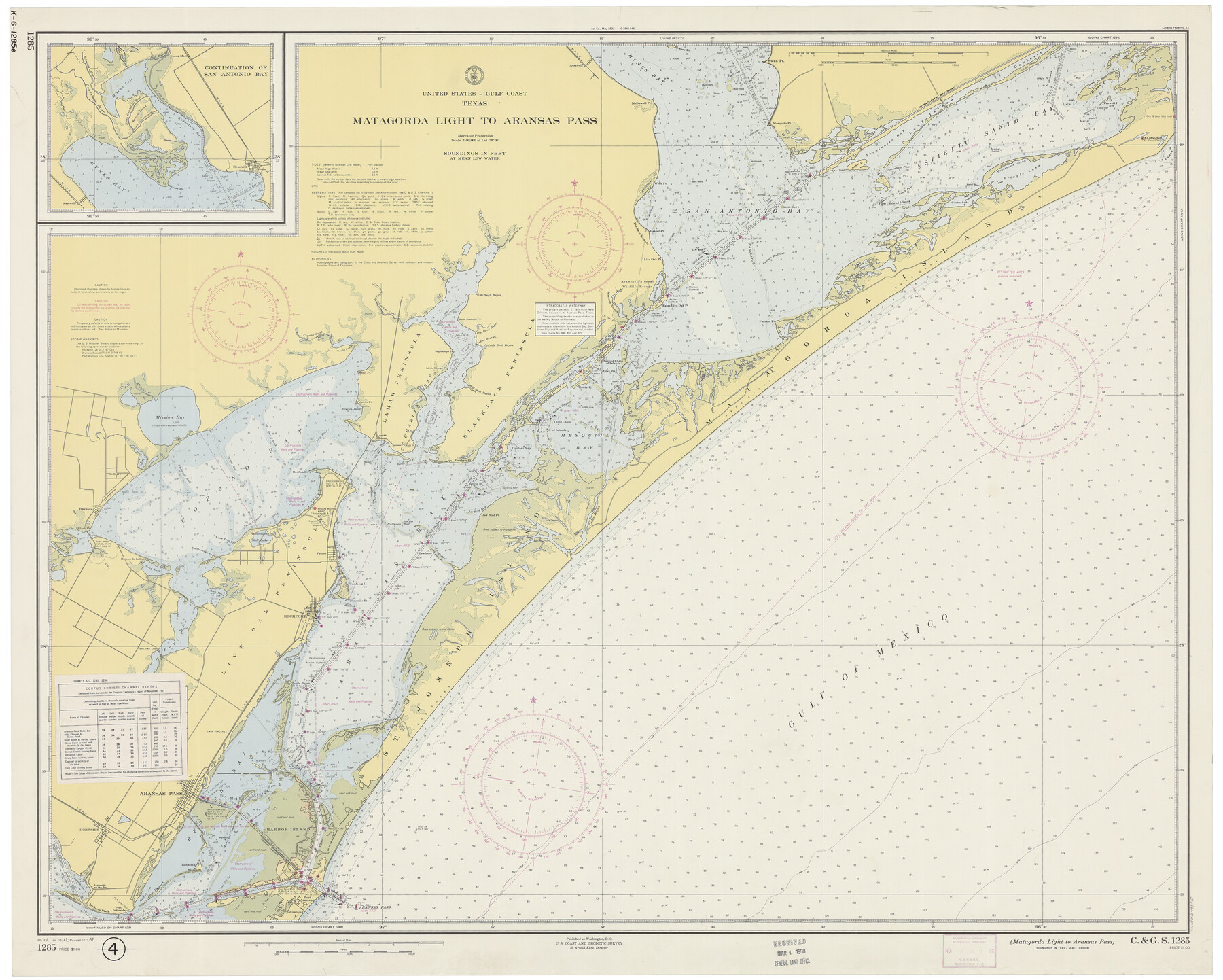
Matagorda Light to Aransas Pass
K-6-1285a
-
Map/Doc
73395
-
Collection
General Map Collection
-
Object Dates
12/2/1957 (Creation Date)
-
Counties
Refugio San Patricio Aransas
-
Subjects
Nautical Charts
-
Height x Width
35.8 x 44.7 inches
90.9 x 113.5 cm
Part of: General Map Collection

Maverick County Sketch File 23a

Print $20.00
- Digital $50.00
Maverick County Sketch File 23a
Size 41.0 x 41.1 inches
Map/Doc 10537
Oldham County Working Sketch 7

Print $20.00
- Digital $50.00
Oldham County Working Sketch 7
1982
Size 33.4 x 35.6 inches
Map/Doc 71329
Kinney County Working Sketch 49

Print $20.00
- Digital $50.00
Kinney County Working Sketch 49
1980
Size 19.9 x 25.6 inches
Map/Doc 70231
Flight Mission No. DIX-10P, Frame 168, Aransas County

Print $20.00
- Digital $50.00
Flight Mission No. DIX-10P, Frame 168, Aransas County
1956
Size 18.7 x 22.3 inches
Map/Doc 83958
McLennan County

Print $20.00
- Digital $50.00
McLennan County
1946
Size 42.5 x 45.8 inches
Map/Doc 73235
[Sketch for Mineral Application 16696-16697, Pecos River]
![65613, [Sketch for Mineral Application 16696-16697, Pecos River], General Map Collection](https://historictexasmaps.com/wmedia_w700/maps/65613-1.tif.jpg)
Print $40.00
- Digital $50.00
[Sketch for Mineral Application 16696-16697, Pecos River]
Size 36.7 x 68.3 inches
Map/Doc 65613

Flight Mission No. CUG-1P, Frame 86, Kleberg County

Print $20.00
- Digital $50.00
Flight Mission No. CUG-1P, Frame 86, Kleberg County
1956
Size 18.5 x 22.2 inches
Map/Doc 86151
Kendall County

Print $20.00
- Digital $50.00
Kendall County
1946
Size 40.8 x 35.4 inches
Map/Doc 73203
Jasper County Sketch File 12a

Print $16.00
- Digital $50.00
Jasper County Sketch File 12a
1881
Size 13.0 x 8.4 inches
Map/Doc 27794
Presidio County Working Sketch 97

Print $20.00
- Digital $50.00
Presidio County Working Sketch 97
1978
Size 28.2 x 28.0 inches
Map/Doc 71774
You may also like
Flight Mission No. DAG-21K, Frame 37, Matagorda County

Print $20.00
- Digital $50.00
Flight Mission No. DAG-21K, Frame 37, Matagorda County
1952
Size 18.5 x 22.4 inches
Map/Doc 86404
Montgomery County Sketch File 3

Print $12.00
- Digital $50.00
Montgomery County Sketch File 3
1846
Size 4.5 x 8.3 inches
Map/Doc 31770
Val Verde County Sketch File 25

Print $20.00
- Digital $50.00
Val Verde County Sketch File 25
Size 19.8 x 24.6 inches
Map/Doc 12572
Lubbock County Hale County

Print $20.00
- Digital $50.00
Lubbock County Hale County
Size 18.0 x 22.4 inches
Map/Doc 92833
Map of Lands in Pecos County, Texas, Block 1, I. and G. N. RR. Company

Print $20.00
- Digital $50.00
Map of Lands in Pecos County, Texas, Block 1, I. and G. N. RR. Company
1934
Size 21.9 x 16.8 inches
Map/Doc 91640
Nueces County Rolled Sketch M-12

Print $20.00
- Digital $50.00
Nueces County Rolled Sketch M-12
1913
Size 24.9 x 40.0 inches
Map/Doc 7171
Brazos River, Brazos River Sheet 2

Print $20.00
- Digital $50.00
Brazos River, Brazos River Sheet 2
1926
Size 25.2 x 31.0 inches
Map/Doc 78265
[Surveys in Vehlein's Colony along the San Jacinto River and Cedar Bayou]
![75, [Surveys in Vehlein's Colony along the San Jacinto River and Cedar Bayou], General Map Collection](https://historictexasmaps.com/wmedia_w700/maps/75.tif.jpg)
Print $20.00
- Digital $50.00
[Surveys in Vehlein's Colony along the San Jacinto River and Cedar Bayou]
1837
Size 17.5 x 15.1 inches
Map/Doc 75
Shelby County Rolled Sketch 11

Print $20.00
- Digital $50.00
Shelby County Rolled Sketch 11
1945
Size 24.9 x 28.6 inches
Map/Doc 7779
Plat in Pecos County, Texas

Print $20.00
- Digital $50.00
Plat in Pecos County, Texas
Size 32.8 x 23.2 inches
Map/Doc 91613
Map of Taylor County

Print $20.00
- Digital $50.00
Map of Taylor County
1858
Size 24.0 x 25.3 inches
Map/Doc 4070
Donley County Sketch File 10

Print $8.00
- Digital $50.00
Donley County Sketch File 10
1889
Size 9.6 x 6.1 inches
Map/Doc 21240