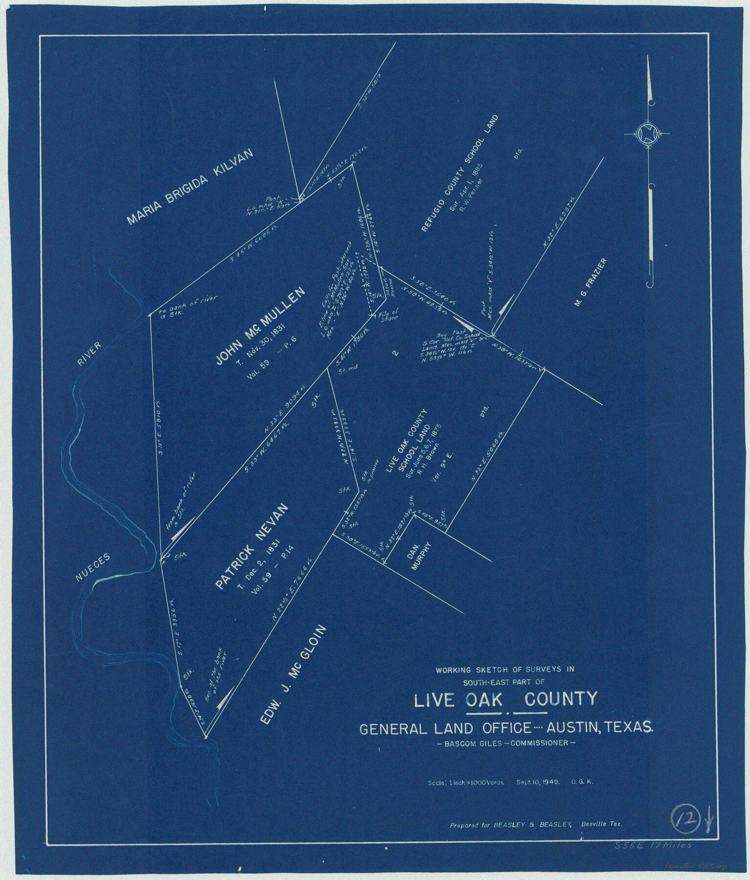
Live Oak County Working Sketch 12
-
Map/Doc
70597
-
Collection
General Map Collection
-
Object Dates
9/10/1949 (Creation Date)
-
People and Organizations
Otto G. Kurio (Draftsman)
-
Counties
Live Oak
-
Subjects
Surveying Working Sketch
-
Height x Width
23.1 x 19.7 inches
58.7 x 50.0 cm
-
Scale
1" = 1000 varas
Part of: General Map Collection
Parker County Sketch File 2

Print $4.00
- Digital $50.00
Parker County Sketch File 2
1856
Size 12.7 x 8.2 inches
Map/Doc 33519
No. 2 Chart of Corpus Christi Pass, Texas

Print $20.00
- Digital $50.00
No. 2 Chart of Corpus Christi Pass, Texas
1878
Size 18.3 x 27.4 inches
Map/Doc 73019
Victoria County Rolled Sketch 4C

Print $40.00
- Digital $50.00
Victoria County Rolled Sketch 4C
1963
Size 65.0 x 43.3 inches
Map/Doc 10097
Plan of the City of Galveston, Texas

Print $20.00
- Digital $50.00
Plan of the City of Galveston, Texas
1845
Size 18.2 x 27.4 inches
Map/Doc 62969

Crane County Sketch File 3b

Print $20.00
- Digital $50.00
Crane County Sketch File 3b
1881
Size 11.9 x 38.6 inches
Map/Doc 11206
Newton County Rolled Sketch 17A

Print $655.00
- Digital $50.00
Newton County Rolled Sketch 17A
Size 11.0 x 16.2 inches
Map/Doc 47011
Dallas County

Print $20.00
- Digital $50.00
Dallas County
1942
Size 44.5 x 36.9 inches
Map/Doc 95475
Kleberg County Rolled Sketch 7

Print $20.00
- Digital $50.00
Kleberg County Rolled Sketch 7
1947
Size 28.5 x 41.4 inches
Map/Doc 6550
Dallas County Boundary File 6d

Print $104.00
- Digital $50.00
Dallas County Boundary File 6d
Size 14.2 x 8.6 inches
Map/Doc 52229
Flight Mission No. BQY-4M, Frame 63, Harris County

Print $20.00
- Digital $50.00
Flight Mission No. BQY-4M, Frame 63, Harris County
1953
Size 18.7 x 22.4 inches
Map/Doc 85272
Hamilton County Working Sketch 21

Print $40.00
- Digital $50.00
Hamilton County Working Sketch 21
1955
Size 52.4 x 43.7 inches
Map/Doc 63359
You may also like
Real County Working Sketch 86

Print $20.00
- Digital $50.00
Real County Working Sketch 86
1988
Size 37.8 x 26.6 inches
Map/Doc 71978
Sutton County Rolled Sketch 68

Print $20.00
- Digital $50.00
Sutton County Rolled Sketch 68
Size 31.0 x 37.4 inches
Map/Doc 9980
PSL Field Notes for Block CS in Hartley County

PSL Field Notes for Block CS in Hartley County
Map/Doc 81656
Flight Mission No. DCL-7C, Frame 41, Kenedy County

Print $20.00
- Digital $50.00
Flight Mission No. DCL-7C, Frame 41, Kenedy County
1943
Size 15.4 x 15.2 inches
Map/Doc 86029
Crane County Rolled Sketch 26

Print $20.00
- Digital $50.00
Crane County Rolled Sketch 26
2020
Size 36.5 x 24.5 inches
Map/Doc 96432
Edwards County Sketch File 19

Print $20.00
- Digital $50.00
Edwards County Sketch File 19
Size 17.1 x 23.7 inches
Map/Doc 11430
Kerr County Sketch File 22

Print $8.00
- Digital $50.00
Kerr County Sketch File 22
Size 11.3 x 8.7 inches
Map/Doc 28897
Cottle County Working Sketch 11

Print $20.00
- Digital $50.00
Cottle County Working Sketch 11
1943
Size 19.2 x 24.1 inches
Map/Doc 68321
Kendall County Working Sketch 22

Print $20.00
- Digital $50.00
Kendall County Working Sketch 22
1971
Size 41.6 x 34.7 inches
Map/Doc 66694
General Highway Map, Parker County, Texas

Print $20.00
General Highway Map, Parker County, Texas
1961
Size 18.3 x 24.5 inches
Map/Doc 79625
Map of a resurvey of the land involved in the suit of Lillian-Vineyard vs. O.M. O'Connor et al (Lamar townlots excepted)

Print $20.00
- Digital $50.00
Map of a resurvey of the land involved in the suit of Lillian-Vineyard vs. O.M. O'Connor et al (Lamar townlots excepted)
1911
Size 18.8 x 17.9 inches
Map/Doc 481
Lamb County Working Sketch 1

Print $20.00
- Digital $50.00
Lamb County Working Sketch 1
1917
Size 40.2 x 43.4 inches
Map/Doc 70274