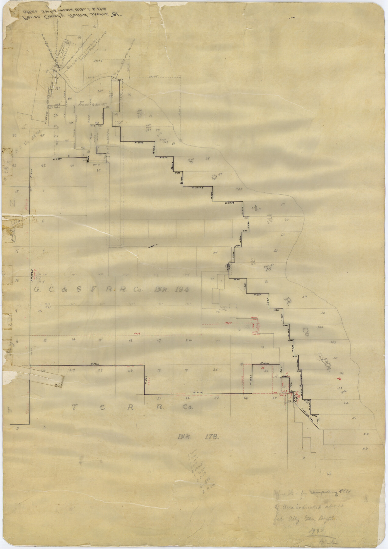
Pecos County Rolled Sketch 81
[Sketch of area around Block 194, G. C. & S. F. R.R. Co.]
-
Map/Doc
7240
-
Collection
General Map Collection
-
Object Dates
1930 (Creation Date)
-
Counties
Pecos
-
Subjects
Surveying Rolled Sketch
-
Height x Width
35.9 x 25.4 inches
91.2 x 64.5 cm
-
Medium
paper, manuscript
Part of: General Map Collection
Flight Mission No. CUG-1P, Frame 52, Kleberg County

Print $20.00
- Digital $50.00
Flight Mission No. CUG-1P, Frame 52, Kleberg County
1956
Size 18.5 x 22.2 inches
Map/Doc 86130
Galveston County NRC Article 33.136 Sketch 79

Print $292.00
- Digital $50.00
Galveston County NRC Article 33.136 Sketch 79
2015
Size 22.0 x 34.0 inches
Map/Doc 94880
Right of Way and Track Map International & Gt Northern Ry. operated by the International & Gt. Northern Ry. Co., San Antonio Division

Print $40.00
- Digital $50.00
Right of Way and Track Map International & Gt Northern Ry. operated by the International & Gt. Northern Ry. Co., San Antonio Division
1917
Size 25.5 x 57.3 inches
Map/Doc 64589
Hays County Rolled Sketch 31

Print $20.00
- Digital $50.00
Hays County Rolled Sketch 31
2001
Size 24.0 x 34.7 inches
Map/Doc 76421
Navasota River, Springfield Sheet

Print $20.00
- Digital $50.00
Navasota River, Springfield Sheet
1934
Size 41.5 x 37.8 inches
Map/Doc 65074
Wichita County

Print $20.00
- Digital $50.00
Wichita County
1971
Size 35.8 x 37.7 inches
Map/Doc 77457
Blanco County Working Sketch 32

Print $20.00
- Digital $50.00
Blanco County Working Sketch 32
1972
Size 31.8 x 32.2 inches
Map/Doc 67392
Frio County Working Sketch 19

Print $20.00
- Digital $50.00
Frio County Working Sketch 19
1982
Size 36.5 x 34.4 inches
Map/Doc 69293
Oldham County Working Sketch 5

Print $40.00
- Digital $50.00
Oldham County Working Sketch 5
1951
Size 43.0 x 59.3 inches
Map/Doc 71327

W. M. Kuykendall Ranch, Matagorda County, Texas

Print $20.00
- Digital $50.00
W. M. Kuykendall Ranch, Matagorda County, Texas
1926
Size 24.3 x 39.6 inches
Map/Doc 3028
Limestone County Working Sketch 25

Print $20.00
- Digital $50.00
Limestone County Working Sketch 25
1981
Size 26.1 x 21.1 inches
Map/Doc 70575
You may also like
Floyd County Boundary File 4

Print $4.00
- Digital $50.00
Floyd County Boundary File 4
Size 11.2 x 8.9 inches
Map/Doc 53494

Map of Galveston West Bay, Galveston Island & Chocolate Bay

Print $40.00
- Digital $50.00
Map of Galveston West Bay, Galveston Island & Chocolate Bay
1852
Size 50.5 x 29.9 inches
Map/Doc 69924
[Blks. B9, J, D19, John Walker]
![90480, [Blks. B9, J, D19, John Walker], Twichell Survey Records](https://historictexasmaps.com/wmedia_w700/maps/90480-1.tif.jpg)
Print $20.00
- Digital $50.00
[Blks. B9, J, D19, John Walker]
Size 28.6 x 15.9 inches
Map/Doc 90480
Map of Burnet County

Print $20.00
- Digital $50.00
Map of Burnet County
1862
Size 27.1 x 22.5 inches
Map/Doc 3353
Burleson County Working Sketch 31

Print $40.00
- Digital $50.00
Burleson County Working Sketch 31
1981
Size 70.6 x 37.8 inches
Map/Doc 67750
Upton County Rolled Sketch 40

Print $20.00
- Digital $50.00
Upton County Rolled Sketch 40
Size 26.2 x 39.7 inches
Map/Doc 8079
Howard County Working Sketch 7b

Print $40.00
- Digital $50.00
Howard County Working Sketch 7b
1950
Size 83.3 x 25.6 inches
Map/Doc 66274
Jeff Davis County Working Sketch 40

Print $20.00
- Digital $50.00
Jeff Davis County Working Sketch 40
1981
Size 19.6 x 37.6 inches
Map/Doc 66535
Dawson County Sketch

Print $20.00
- Digital $50.00
Dawson County Sketch
Size 37.0 x 20.5 inches
Map/Doc 92628
Collin County Sketch File 15

Print $4.00
- Digital $50.00
Collin County Sketch File 15
1873
Size 10.0 x 8.0 inches
Map/Doc 18880
Galveston County NRC Article 33.136 Sketch 95

Print $40.00
Galveston County NRC Article 33.136 Sketch 95
2024
Map/Doc 97368