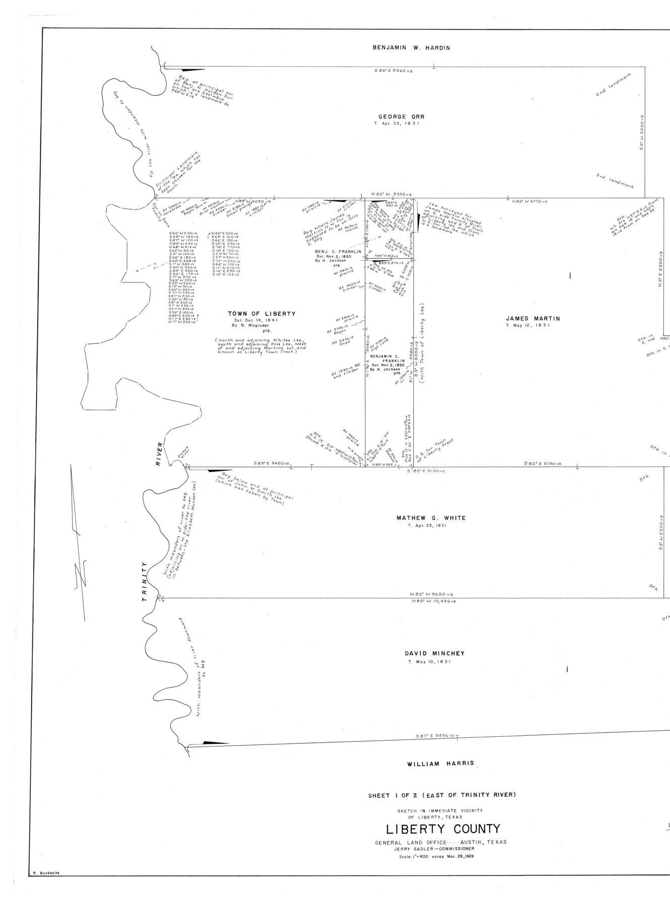
Liberty County Working Sketch 61
-
Map/Doc
70521
-
Collection
General Map Collection
-
Object Dates
3/28/1969 (Creation Date)
-
People and Organizations
Roy Buckholts (Draftsman)
-
Counties
Liberty
-
Subjects
Surveying Working Sketch
-
Height x Width
43.3 x 32.0 inches
110.0 x 81.3 cm
-
Scale
1" = 400 varas
Part of: General Map Collection
McLennan County Working Sketch 3

Print $20.00
- Digital $50.00
McLennan County Working Sketch 3
1941
Size 18.0 x 17.9 inches
Map/Doc 70696
Henderson County Boundary File 2a

Print $12.00
- Digital $50.00
Henderson County Boundary File 2a
Size 14.2 x 8.8 inches
Map/Doc 54656
Plan of Three Sitios of Land Granted to Vicente Micheli

Print $2.00
- Digital $50.00
Plan of Three Sitios of Land Granted to Vicente Micheli
Size 9.2 x 8.6 inches
Map/Doc 18
Tom Green County Rolled Sketch 28

Print $20.00
- Digital $50.00
Tom Green County Rolled Sketch 28
Size 25.3 x 25.4 inches
Map/Doc 8008
[Surveys between Upper Keechi Creek and the Trinity River]
![293, [Surveys between Upper Keechi Creek and the Trinity River], General Map Collection](https://historictexasmaps.com/wmedia_w700/maps/293.tif.jpg)
Print $2.00
- Digital $50.00
[Surveys between Upper Keechi Creek and the Trinity River]
Size 8.5 x 6.9 inches
Map/Doc 293
Atascosa County Working Sketch 36

Print $20.00
- Digital $50.00
Atascosa County Working Sketch 36
2008
Size 29.4 x 44.5 inches
Map/Doc 88878
Jefferson County Boundary File 1

Print $10.00
- Digital $50.00
Jefferson County Boundary File 1
Size 9.8 x 6.7 inches
Map/Doc 55514
Harris County Sketch File B

Print $4.00
- Digital $50.00
Harris County Sketch File B
1860
Size 8.0 x 5.5 inches
Map/Doc 25309
Bandera County Working Sketch 33

Print $20.00
- Digital $50.00
Bandera County Working Sketch 33
1961
Size 22.4 x 28.8 inches
Map/Doc 67629
San Patricio County Sketch File 32

Print $20.00
- Digital $50.00
San Patricio County Sketch File 32
Size 13.7 x 30.3 inches
Map/Doc 12287
Presidio County Sketch File 60b

Print $4.00
- Digital $50.00
Presidio County Sketch File 60b
1936
Size 14.4 x 8.8 inches
Map/Doc 34645
Stonewall County Sketch File 21

Print $4.00
- Digital $50.00
Stonewall County Sketch File 21
1933
Size 7.1 x 8.7 inches
Map/Doc 37291
You may also like
Potter County Working Sketch 6

Print $20.00
- Digital $50.00
Potter County Working Sketch 6
1959
Size 23.3 x 27.0 inches
Map/Doc 71666
Galveston County Sketch File 65

Print $70.00
- Digital $50.00
Galveston County Sketch File 65
1892
Size 8.7 x 5.8 inches
Map/Doc 23717
[Sketch for Mineral Application 26501 - Sabine River, T. A. Oldhausen]
![2840, [Sketch for Mineral Application 26501 - Sabine River, T. A. Oldhausen], General Map Collection](https://historictexasmaps.com/wmedia_w700/maps/2840.tif.jpg)
Print $20.00
- Digital $50.00
[Sketch for Mineral Application 26501 - Sabine River, T. A. Oldhausen]
1931
Size 24.3 x 35.5 inches
Map/Doc 2840
Duval County Working Sketch 26

Print $20.00
- Digital $50.00
Duval County Working Sketch 26
1947
Size 34.8 x 36.9 inches
Map/Doc 68750
Liberty County Sketch File 67

Print $28.00
- Digital $50.00
Liberty County Sketch File 67
1996
Size 11.3 x 8.8 inches
Map/Doc 30135
Webb County Working Sketch 32

Print $20.00
- Digital $50.00
Webb County Working Sketch 32
1937
Size 34.5 x 36.0 inches
Map/Doc 72397
Kinney County Working Sketch 53

Print $20.00
- Digital $50.00
Kinney County Working Sketch 53
1981
Size 23.7 x 23.0 inches
Map/Doc 70235
Duval County Sketch File 73

Print $4.00
- Digital $50.00
Duval County Sketch File 73
Size 9.9 x 8.8 inches
Map/Doc 21463
Potter County Sketch File 21

Print $6.00
- Digital $50.00
Potter County Sketch File 21
1930
Size 14.1 x 9.7 inches
Map/Doc 34413
Crockett County Rolled Sketch 26

Print $20.00
- Digital $50.00
Crockett County Rolled Sketch 26
Size 33.7 x 40.9 inches
Map/Doc 5585
Bexar County Boundary File 3

Print $6.00
- Digital $50.00
Bexar County Boundary File 3
Size 8.2 x 3.6 inches
Map/Doc 50536
