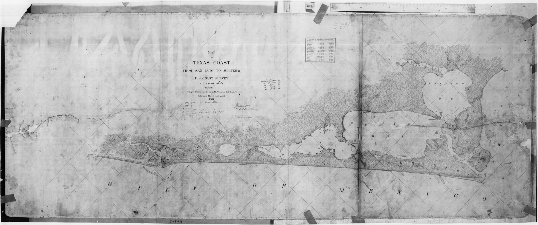
Map of Texas Coast from San Luis to Jupiter
C-7-11
-
Map/Doc
69975
-
Collection
General Map Collection
-
Object Dates
1852 (Creation Date)
-
Counties
Brazoria
-
Subjects
Nautical Charts
-
Height x Width
31.3 x 74.7 inches
79.5 x 189.7 cm
Part of: General Map Collection
Reagan County Sketch File RB

Print $8.00
- Digital $50.00
Reagan County Sketch File RB
Size 11.3 x 9.0 inches
Map/Doc 34996
Jasper County Sketch File 20

Print $4.00
- Digital $50.00
Jasper County Sketch File 20
Size 8.7 x 12.2 inches
Map/Doc 27818
Frio County Working Sketch 24

Print $20.00
- Digital $50.00
Frio County Working Sketch 24
1992
Size 47.0 x 35.2 inches
Map/Doc 69298
Gulf Oil Corp. Fishgide - Port O'Connor

Gulf Oil Corp. Fishgide - Port O'Connor
1960
Size 12.2 x 22.3 inches
Map/Doc 75983
McMullen County Sketch File 36

Print $8.00
- Digital $50.00
McMullen County Sketch File 36
Size 4.8 x 8.2 inches
Map/Doc 31406
Webb County Working Sketch 93

Print $20.00
- Digital $50.00
Webb County Working Sketch 93
1989
Size 15.7 x 20.1 inches
Map/Doc 72460
Uvalde County Working Sketch 54

Print $20.00
- Digital $50.00
Uvalde County Working Sketch 54
1983
Size 39.6 x 32.3 inches
Map/Doc 72124
Culberson County Rolled Sketch 45

Print $20.00
- Digital $50.00
Culberson County Rolled Sketch 45
1954
Size 19.1 x 23.4 inches
Map/Doc 5667
Map of Titus County

Print $20.00
- Digital $50.00
Map of Titus County
1857
Size 24.1 x 34.5 inches
Map/Doc 83380
Reagan County Sketch File 34

Print $4.00
- Digital $50.00
Reagan County Sketch File 34
Size 11.5 x 8.9 inches
Map/Doc 35030
Flight Mission No. BRA-7M, Frame 129, Jefferson County

Print $20.00
- Digital $50.00
Flight Mission No. BRA-7M, Frame 129, Jefferson County
1953
Size 16.3 x 16.0 inches
Map/Doc 85523
A Pocket Guide to Austin, Texas - Area Map and Downtown Map

A Pocket Guide to Austin, Texas - Area Map and Downtown Map
Size 17.2 x 20.2 inches
Map/Doc 94386
You may also like
Taylor County Working Sketch 16

Print $20.00
- Digital $50.00
Taylor County Working Sketch 16
1981
Size 28.8 x 41.2 inches
Map/Doc 69626
[Surveys along the Frio River]
![129, [Surveys along the Frio River], General Map Collection](https://historictexasmaps.com/wmedia_w700/maps/129.tif.jpg)
Print $20.00
- Digital $50.00
[Surveys along the Frio River]
1841
Size 12.0 x 16.6 inches
Map/Doc 129
Wichita County Working Sketch 21

Print $20.00
- Digital $50.00
Wichita County Working Sketch 21
1951
Size 28.4 x 30.2 inches
Map/Doc 72531
Flight Mission No. BRA-7M, Frame 76, Jefferson County

Print $20.00
- Digital $50.00
Flight Mission No. BRA-7M, Frame 76, Jefferson County
1953
Size 18.8 x 22.3 inches
Map/Doc 85498
Packery Channel

Print $3.00
- Digital $50.00
Packery Channel
1972
Size 10.6 x 17.8 inches
Map/Doc 2999
Map of Texas and Adjacent Regions in the Eighteenth Century

Print $20.00
- Digital $50.00
Map of Texas and Adjacent Regions in the Eighteenth Century
1915
Size 16.7 x 20.0 inches
Map/Doc 94007
Garza County Sketch File 1

Print $4.00
- Digital $50.00
Garza County Sketch File 1
1879
Size 9.2 x 8.1 inches
Map/Doc 24044

Refugio County Sketch File 11

Print $6.00
- Digital $50.00
Refugio County Sketch File 11
Size 8.0 x 8.2 inches
Map/Doc 35260
San Saba County Rolled Sketch 3

Print $20.00
- Digital $50.00
San Saba County Rolled Sketch 3
Size 31.9 x 43.3 inches
Map/Doc 7744
Bee County Working Sketch 34

Print $20.00
- Digital $50.00
Bee County Working Sketch 34
1988
Size 46.3 x 43.6 inches
Map/Doc 67285
General Highway Map, Bowie County, Texas

Print $20.00
General Highway Map, Bowie County, Texas
1961
Size 18.2 x 25.0 inches
Map/Doc 79380