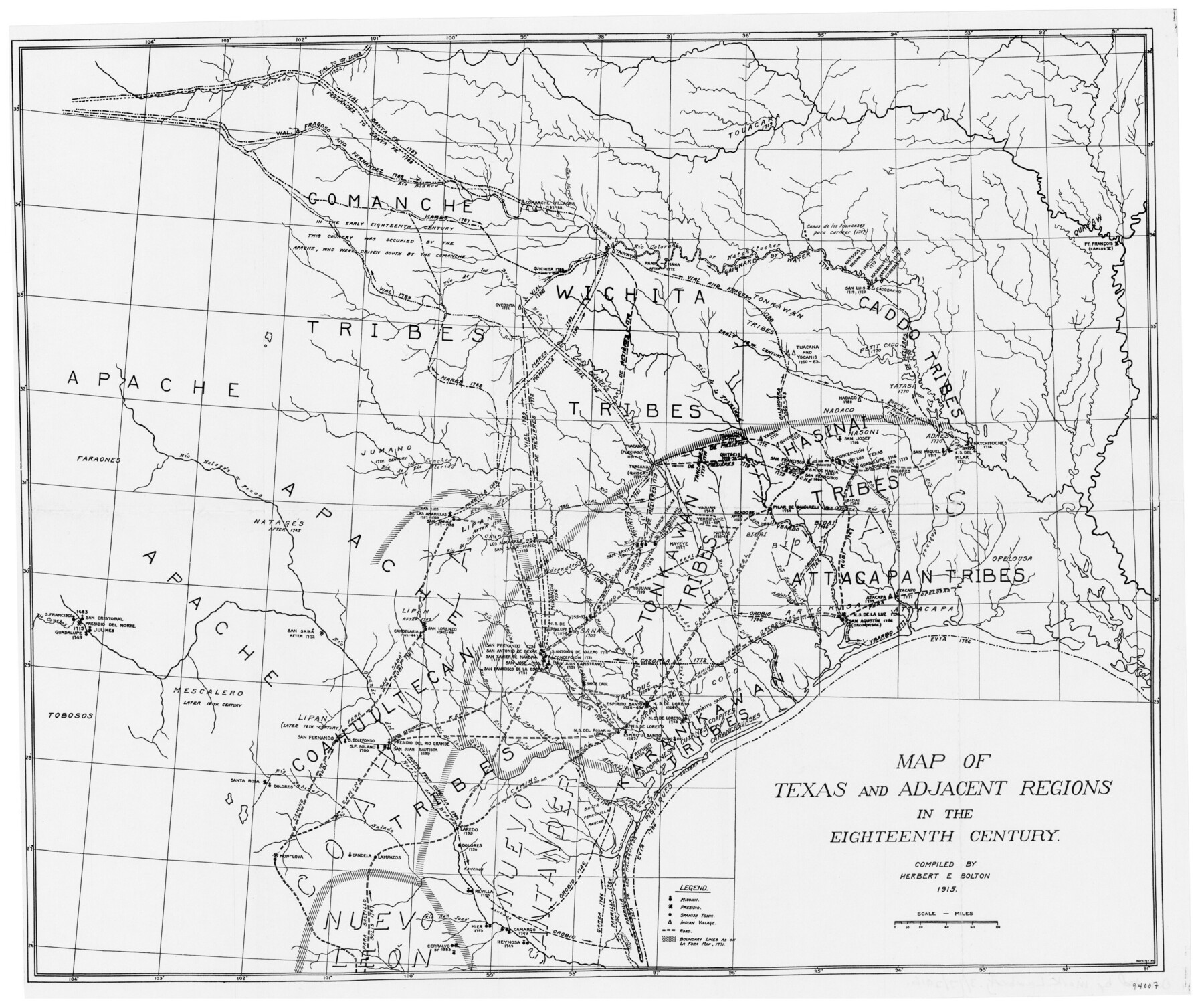
Map of Texas and Adjacent Regions in the Eighteenth Century
-
Map/Doc
94007
-
Collection
General Map Collection
-
Object Dates
1915 (Creation Date)
-
People and Organizations
Herbert E. Bolton (Compiler)
-
Subjects
State of Texas
-
Height x Width
16.7 x 20.0 inches
42.4 x 50.8 cm
-
Medium
paper
-
Comments
Map highlights locations of various Native American tribes.
Part of: General Map Collection
Val Verde County Rolled Sketch 42

Print $20.00
- Digital $50.00
Val Verde County Rolled Sketch 42
1919
Size 17.3 x 21.9 inches
Map/Doc 8116
Kimble County Rolled Sketch 40

Print $20.00
- Digital $50.00
Kimble County Rolled Sketch 40
Size 27.5 x 22.4 inches
Map/Doc 6530
Borden County Sketch File 11

Print $4.00
- Digital $50.00
Borden County Sketch File 11
1892
Size 11.0 x 8.9 inches
Map/Doc 14730
Ward County Working Sketch 17

Print $20.00
- Digital $50.00
Ward County Working Sketch 17
1948
Size 30.1 x 32.5 inches
Map/Doc 72323
Flight Mission No. DIX-5P, Frame 106, Aransas County

Print $20.00
- Digital $50.00
Flight Mission No. DIX-5P, Frame 106, Aransas County
1956
Size 17.8 x 18.0 inches
Map/Doc 83784
Texas State Boundary Line 7

Print $182.00
Texas State Boundary Line 7
2000
Size 11.2 x 8.8 inches
Map/Doc 75018
Newton County Working Sketch 45

Print $20.00
- Digital $50.00
Newton County Working Sketch 45
1996
Size 16.4 x 24.0 inches
Map/Doc 71291
Jasper County

Print $40.00
- Digital $50.00
Jasper County
1898
Size 65.1 x 37.4 inches
Map/Doc 82048
Flight Mission No. CGI-3N, Frame 162, Cameron County

Print $20.00
- Digital $50.00
Flight Mission No. CGI-3N, Frame 162, Cameron County
1954
Size 18.6 x 22.3 inches
Map/Doc 84626
Van Zandt County Sketch File 11

Print $4.00
- Digital $50.00
Van Zandt County Sketch File 11
1858
Size 10.2 x 8.1 inches
Map/Doc 39397
Crockett County Rolled Sketch JAS

Print $40.00
- Digital $50.00
Crockett County Rolled Sketch JAS
1938
Size 52.9 x 42.7 inches
Map/Doc 8699
Flight Mission No. CRE-1R, Frame 197, Jackson County

Print $20.00
- Digital $50.00
Flight Mission No. CRE-1R, Frame 197, Jackson County
1956
Size 18.5 x 22.4 inches
Map/Doc 85351
You may also like
The Judicial District/County of Lavaca. Abolished, Spring 1842

Print $20.00
The Judicial District/County of Lavaca. Abolished, Spring 1842
2020
Size 14.6 x 21.7 inches
Map/Doc 96332
Newton County Rolled Sketch 21

Print $40.00
- Digital $50.00
Newton County Rolled Sketch 21
1957
Size 29.9 x 52.5 inches
Map/Doc 9582
Flight Mission No. BQR-13K, Frame 166, Brazoria County

Print $20.00
- Digital $50.00
Flight Mission No. BQR-13K, Frame 166, Brazoria County
1952
Size 18.8 x 22.3 inches
Map/Doc 84091
Flight Mission No. DQN-7K, Frame 88, Calhoun County

Print $20.00
- Digital $50.00
Flight Mission No. DQN-7K, Frame 88, Calhoun County
1953
Size 18.5 x 22.1 inches
Map/Doc 84479
Flight Mission No. DQN-2K, Frame 22, Calhoun County

Print $20.00
- Digital $50.00
Flight Mission No. DQN-2K, Frame 22, Calhoun County
1953
Size 16.9 x 18.9 inches
Map/Doc 84229
Gonzales County Working Sketch 8

Print $20.00
- Digital $50.00
Gonzales County Working Sketch 8
1981
Size 19.0 x 16.7 inches
Map/Doc 63224
[Blocks M1 and 3T]
![93008, [Blocks M1 and 3T], Twichell Survey Records](https://historictexasmaps.com/wmedia_w700/maps/93008-1.tif.jpg)
Print $2.00
- Digital $50.00
[Blocks M1 and 3T]
Size 15.6 x 6.4 inches
Map/Doc 93008
Harris County Rolled Sketch 69

Print $40.00
- Digital $50.00
Harris County Rolled Sketch 69
Size 37.0 x 58.5 inches
Map/Doc 9131
Llano County Sketch File 13

Print $4.00
- Digital $50.00
Llano County Sketch File 13
1891
Size 9.2 x 15.3 inches
Map/Doc 30387
South Montgomery County, Woodlands Chamber of Commerce Street Map

South Montgomery County, Woodlands Chamber of Commerce Street Map
Size 50.0 x 37.8 inches
Map/Doc 94364
Collin County Working Sketch 4

Print $20.00
- Digital $50.00
Collin County Working Sketch 4
1953
Size 20.4 x 21.8 inches
Map/Doc 68098
United States - Gulf Coast - Galveston to Rio Grande

Print $20.00
- Digital $50.00
United States - Gulf Coast - Galveston to Rio Grande
1919
Size 27.1 x 18.3 inches
Map/Doc 72749