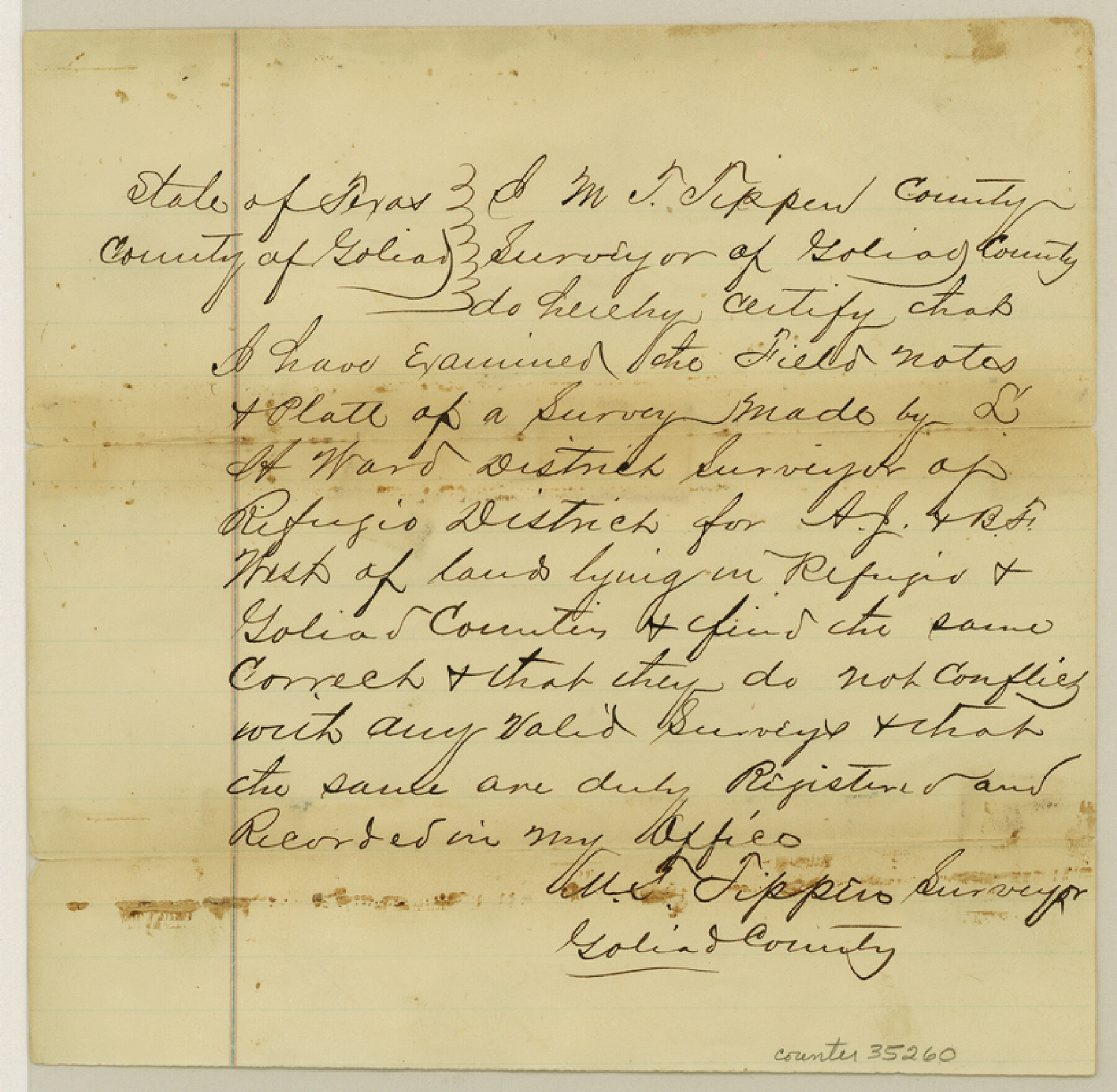
Refugio County Sketch File 11
[Sketch of C. E. P. I. & M. Co. surveys north of Refugio near the Goliad County line]
-
Map/Doc
35260
-
Collection
General Map Collection
-
Object Dates
8/10/1876 (File Date)
-
People and Organizations
L.H. Ward (Surveyor/Engineer)
-
Counties
Refugio Goliad
-
Subjects
Surveying Sketch File
-
Height x Width
8.0 x 8.2 inches
20.3 x 20.8 cm
-
Medium
paper, manuscript
-
Features
Agua Sarca Creek
Part of: General Map Collection
Kimble County Working Sketch 87

Print $20.00
- Digital $50.00
Kimble County Working Sketch 87
1974
Size 24.1 x 30.0 inches
Map/Doc 70155
Padre Island, Register No. 1485a

Print $40.00
- Digital $50.00
Padre Island, Register No. 1485a
1881
Size 55.7 x 36.7 inches
Map/Doc 73609
Tyler County Working Sketch 17

Print $20.00
- Digital $50.00
Tyler County Working Sketch 17
1962
Size 33.1 x 38.9 inches
Map/Doc 69487
Hunt County Boundary File 3

Print $12.00
- Digital $50.00
Hunt County Boundary File 3
Size 10.5 x 8.4 inches
Map/Doc 55208
Newton County Rolled Sketch 25

Print $20.00
- Digital $50.00
Newton County Rolled Sketch 25
1893
Size 17.0 x 21.3 inches
Map/Doc 6855
Packery Channel

Print $20.00
- Digital $50.00
Packery Channel
1937
Size 23.8 x 22.4 inches
Map/Doc 3008
Galveston County NRC Article 33.136 Sketch 36

Print $28.00
- Digital $50.00
Galveston County NRC Article 33.136 Sketch 36
2005
Size 24.5 x 36.6 inches
Map/Doc 83409
Montgomery County Rolled Sketch 35

Print $40.00
- Digital $50.00
Montgomery County Rolled Sketch 35
Size 36.7 x 51.3 inches
Map/Doc 9543
Medina County Working Sketch 16

Print $20.00
- Digital $50.00
Medina County Working Sketch 16
1979
Size 27.1 x 28.2 inches
Map/Doc 70931
San Patricio County Rolled Sketch 17

Print $20.00
- Digital $50.00
San Patricio County Rolled Sketch 17
1917
Size 18.1 x 28.1 inches
Map/Doc 7574
Map of Nacogdoches County

Print $20.00
- Digital $50.00
Map of Nacogdoches County
1881
Size 24.5 x 21.8 inches
Map/Doc 4604
El Paso County Sketch File 40

Print $20.00
- Digital $50.00
El Paso County Sketch File 40
1988
Size 24.8 x 35.9 inches
Map/Doc 11461
You may also like
The Compass Rose of Austin's Colony

Price $20.00
The Compass Rose of Austin's Colony
2016
Size 4.0 x 3.5 inches
Map/Doc 94443
Presidio County Rolled Sketch 39

Print $20.00
- Digital $50.00
Presidio County Rolled Sketch 39
Size 16.0 x 22.0 inches
Map/Doc 7336
Harrison County Sketch File 14

Print $32.00
- Digital $50.00
Harrison County Sketch File 14
1880
Size 11.2 x 8.8 inches
Map/Doc 26053
Live Oak County Working Sketch 36

Print $20.00
- Digital $50.00
Live Oak County Working Sketch 36
2008
Size 33.5 x 35.8 inches
Map/Doc 88879
Travis County Boundary File 30

Print $4.00
- Digital $50.00
Travis County Boundary File 30
Size 10.4 x 8.6 inches
Map/Doc 59469
[Surveys in McMullen and McGloin's Colony along the San Antonio River]
![30, [Surveys in McMullen and McGloin's Colony along the San Antonio River], General Map Collection](https://historictexasmaps.com/wmedia_w700/maps/30-1.tif.jpg)
Print $20.00
- Digital $50.00
[Surveys in McMullen and McGloin's Colony along the San Antonio River]
1828
Size 19.3 x 24.5 inches
Map/Doc 30

Tom Green County Rolled Sketch 20

Print $20.00
- Digital $50.00
Tom Green County Rolled Sketch 20
Size 20.7 x 13.3 inches
Map/Doc 8003
Flight Mission No. DAH-9M, Frame 206, Orange County

Print $20.00
- Digital $50.00
Flight Mission No. DAH-9M, Frame 206, Orange County
1953
Size 18.7 x 22.7 inches
Map/Doc 86874
[Area to the West and North of the Abraham Winfrey survey 11]
![90228, [Area to the West and North of the Abraham Winfrey survey 11], Twichell Survey Records](https://historictexasmaps.com/wmedia_w700/maps/90228-1.tif.jpg)
Print $20.00
- Digital $50.00
[Area to the West and North of the Abraham Winfrey survey 11]
1920
Size 23.2 x 24.1 inches
Map/Doc 90228
Tom Green County Rolled Sketch 18

Print $20.00
- Digital $50.00
Tom Green County Rolled Sketch 18
Size 15.7 x 23.8 inches
Map/Doc 8001
Hunt County Sketch File 38

Print $6.00
- Digital $50.00
Hunt County Sketch File 38
Size 11.0 x 10.8 inches
Map/Doc 27157