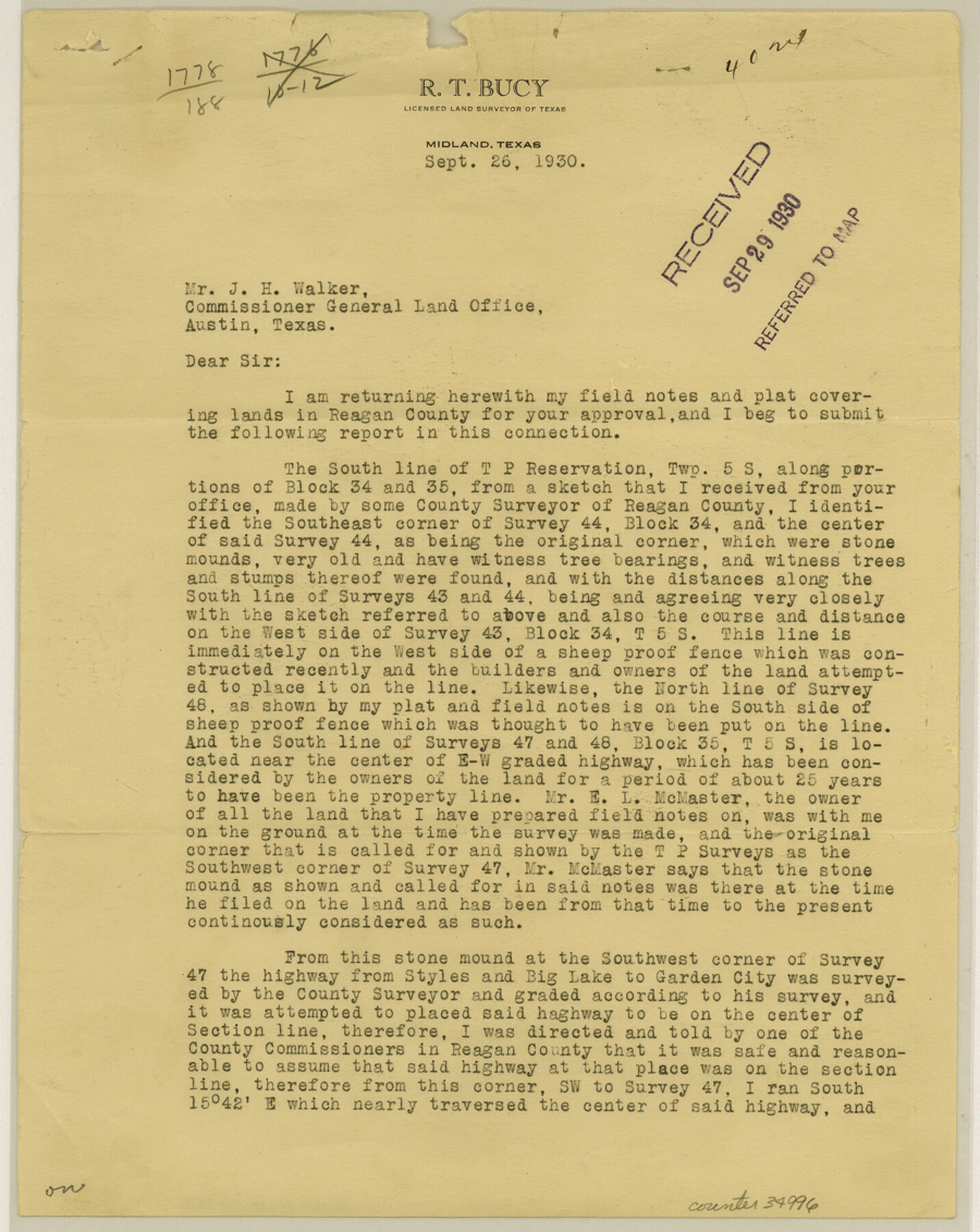
Reagan County Sketch File RB
[Explanation on surveys made in the north part of Reagan County]
-
Map/Doc
34996
-
Collection
General Map Collection
-
Object Dates
1930/9/29 (File Date)
1930/9/26 (Correspondence Date)
-
People and Organizations
R.T. Bucy (Surveyor/Engineer)
H.B. Tarver (Surveyor/Engineer)
Henry M. Dickson (Surveyor/Engineer)
-
Counties
Reagan
-
Subjects
Surveying Sketch File
-
Height x Width
11.3 x 9.0 inches
28.7 x 22.9 cm
-
Medium
paper, print
-
Comments
See Reagan County Rolled Sketch 6 (7435) for sketch.
-
Features
Styles [sic]/Big Lake to Garden City Highway
Related maps
Reagan County Rolled Sketch 6

Print $20.00
- Digital $50.00
Reagan County Rolled Sketch 6
Size 17.8 x 17.3 inches
Map/Doc 7435
Part of: General Map Collection
Harris County Rolled Sketch 76

Print $20.00
- Digital $50.00
Harris County Rolled Sketch 76
1951
Size 37.0 x 24.0 inches
Map/Doc 6113
Clay County Sketch File 37

Print $8.00
- Digital $50.00
Clay County Sketch File 37
1935
Size 11.6 x 7.2 inches
Map/Doc 18465
Clay County Boundary File 11

Print $12.00
- Digital $50.00
Clay County Boundary File 11
Size 14.0 x 8.4 inches
Map/Doc 51400
Andrews County Sketch File 19

Print $12.00
- Digital $50.00
Andrews County Sketch File 19
Size 14.3 x 8.8 inches
Map/Doc 12912
Wheeler County

Print $20.00
- Digital $50.00
Wheeler County
1932
Size 39.5 x 35.0 inches
Map/Doc 77456
Palo Pinto County Working Sketch 2

Print $20.00
- Digital $50.00
Palo Pinto County Working Sketch 2
1906
Size 15.2 x 46.2 inches
Map/Doc 71385
Flight Mission No. BQR-13K, Frame 26, Brazoria County

Print $20.00
- Digital $50.00
Flight Mission No. BQR-13K, Frame 26, Brazoria County
1952
Size 18.7 x 22.4 inches
Map/Doc 84074
Dickens County

Print $20.00
- Digital $50.00
Dickens County
1877
Size 19.1 x 18.4 inches
Map/Doc 3486
Topographical Map of the Rio Grande, Sheet No. 1

Print $20.00
- Digital $50.00
Topographical Map of the Rio Grande, Sheet No. 1
1912
Map/Doc 89525
Bee County Boundary File 7

Print $8.00
- Digital $50.00
Bee County Boundary File 7
Size 12.7 x 8.1 inches
Map/Doc 50460
Leon County Rolled Sketch 12

Print $20.00
- Digital $50.00
Leon County Rolled Sketch 12
1974
Size 46.5 x 40.7 inches
Map/Doc 9431
Donley County Sketch File B5

Print $20.00
- Digital $50.00
Donley County Sketch File B5
1918
Size 22.5 x 18.4 inches
Map/Doc 11375
You may also like
Bandera County Working Sketch 58

Print $20.00
- Digital $50.00
Bandera County Working Sketch 58
2001
Size 34.9 x 36.7 inches
Map/Doc 67654
Erath County Working Sketch 35

Print $20.00
- Digital $50.00
Erath County Working Sketch 35
1973
Size 24.8 x 28.4 inches
Map/Doc 69116
Brazoria County NRC Article 33.136 Sketch 16

Print $72.00
- Digital $50.00
Brazoria County NRC Article 33.136 Sketch 16
2014
Size 22.0 x 36.0 inches
Map/Doc 95037
Flight Mission No. CRK-8P, Frame 121, Refugio County

Print $20.00
- Digital $50.00
Flight Mission No. CRK-8P, Frame 121, Refugio County
1956
Size 18.3 x 22.2 inches
Map/Doc 86976
Montague County Working Sketch 12

Print $20.00
- Digital $50.00
Montague County Working Sketch 12
1937
Size 23.3 x 23.8 inches
Map/Doc 71078
Flight Mission No. BRA-3M, Frame 195, Jefferson County

Print $20.00
- Digital $50.00
Flight Mission No. BRA-3M, Frame 195, Jefferson County
1953
Size 18.6 x 22.3 inches
Map/Doc 85410
Harris County Working Sketch 47

Print $40.00
- Digital $50.00
Harris County Working Sketch 47
1942
Size 39.5 x 51.9 inches
Map/Doc 65939
Current Miscellaneous File 20

Print $22.00
- Digital $50.00
Current Miscellaneous File 20
1952
Size 10.7 x 8.1 inches
Map/Doc 73855
Milam County Working Sketch 5

Print $20.00
- Digital $50.00
Milam County Working Sketch 5
1963
Size 29.1 x 23.7 inches
Map/Doc 71020
Delta County Sketch File 4

Print $4.00
- Digital $50.00
Delta County Sketch File 4
Size 10.9 x 7.3 inches
Map/Doc 20674
Jeff Davis County Sketch File R

Print $12.00
- Digital $50.00
Jeff Davis County Sketch File R
Size 6.0 x 8.7 inches
Map/Doc 28017
Pecos County Working Sketch 40

Print $20.00
- Digital $50.00
Pecos County Working Sketch 40
1941
Size 29.9 x 39.7 inches
Map/Doc 71512