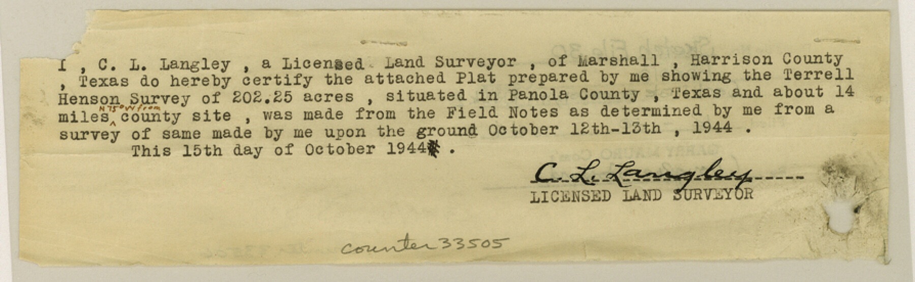
Panola County Sketch File 30
[Certification by a surveyor regarding a submitted plat]
- 
                          Map/Doc
33505
 - 
                            Collection
General Map Collection
 - 
                            Object Dates
10/15/1944 (Creation Date)
12/30/1944 (File Date)
 - 
                            People and Organizations
C.L. Langley (Surveyor/Engineer)
 - 
                            Counties
Panola
 - 
                            Subjects
Surveying Sketch File
 - 
                            Height x Width
2.8 x 8.9 inches
7.1 x 22.6 cm
 - 
                            Medium
paper, print
 - 
                            Comments
See Panola County Rolled Sketch 2 (7197) for sketch.
 
Related maps
            Panola County Rolled Sketch 2


                                            Print $20.00                    
                                             -                         Digital $50.00                                    
                Panola County Rolled Sketch 2
1944
Size 20.7 x 27.0 inches
                                Map/Doc 7197
            Part of: General Map Collection
            Aransas County Sketch File 19


                                            Print $4.00                    
                                             -                         Digital $50.00                                    
                Aransas County Sketch File 19
Size 11.7 x 8.9 inches
                                Map/Doc 13153
            
            Childress County Rolled Sketch 18A


                                            Print $20.00                    
                                             -                         Digital $50.00                                    
                Childress County Rolled Sketch 18A
1913
Size 18.5 x 39.8 inches
                                Map/Doc 5452
            
            Lynn County Working Sketch 5


                                            Print $20.00                    
                                             -                         Digital $50.00                                    
                Lynn County Working Sketch 5
1982
Size 22.5 x 28.2 inches
                                Map/Doc 70675
            
            South Part of Brewster Co.


                                            Print $20.00                    
                                             -                         Digital $50.00                                    
                South Part of Brewster Co.
1955
Size 47.3 x 39.6 inches
                                Map/Doc 77221
            
            Mason County Working Sketch 17


                                            Print $20.00                    
                                             -                         Digital $50.00                                    
                Mason County Working Sketch 17
1983
Size 24.3 x 41.1 inches
                                Map/Doc 70853
            
            El Paso County Boundary File 10


                                            Print $14.00                    
                                             -                         Digital $50.00                                    
                El Paso County Boundary File 10
Size 12.7 x 8.2 inches
                                Map/Doc 53118
            
            Calhoun County Boundary File 4


                                            Print $96.00                    
                                             -                         Digital $50.00                                    
                Calhoun County Boundary File 4
Size 14.3 x 8.7 inches
                                Map/Doc 50979
            
            Milam County Sketch File 4


                                            Print $4.00                    
                                             -                         Digital $50.00                                    
                Milam County Sketch File 4
Size 7.6 x 8.2 inches
                                Map/Doc 31630
            
            Brewster County Rolled Sketch 80


                                            Print $40.00                    
                                             -                         Digital $50.00                                    
                Brewster County Rolled Sketch 80
1943
Size 51.6 x 42.7 inches
                                Map/Doc 8493
            
            Right of Way and Track Map International & Gt. Northern Ry. operated by the International & Gt. Northern Ry. Co., Columbia Branch, Gulf Division


                                            Print $40.00                    
                                             -                         Digital $50.00                                    
                Right of Way and Track Map International & Gt. Northern Ry. operated by the International & Gt. Northern Ry. Co., Columbia Branch, Gulf Division
1917
Size 25.1 x 56.4 inches
                                Map/Doc 64596
            You may also like
            Kent County Working Sketch 13


                                            Print $20.00                    
                                             -                         Digital $50.00                                    
                Kent County Working Sketch 13
1963
Size 27.9 x 44.2 inches
                                Map/Doc 70020
            
            Coke County Rolled Sketch 33


                                            Print $20.00                    
                                             -                         Digital $50.00                                    
                Coke County Rolled Sketch 33
2004
Size 28.9 x 40.5 inches
                                Map/Doc 82987
            
            Castro County Sketch File 18


                                            Print $20.00                    
                                             -                         Digital $50.00                                    
                Castro County Sketch File 18
1988
Size 40.4 x 37.7 inches
                                Map/Doc 10330
            
            Foard County Sketch File 11


                                            Print $4.00                    
                                             -                         Digital $50.00                                    
                Foard County Sketch File 11
Size 7.7 x 10.5 inches
                                Map/Doc 22812
            
            Part of Tom Green County, Texas (No. 3)


                                            Print $20.00                    
                                             -                         Digital $50.00                                    
                Part of Tom Green County, Texas (No. 3)
1870
Size 22.9 x 17.7 inches
                                Map/Doc 5047
            
            Map Showing Resurvey of Capitol Leagues, Bailey, Lamb & Castro Co's.


                                            Print $20.00                    
                                             -                         Digital $50.00                                    
                Map Showing Resurvey of Capitol Leagues, Bailey, Lamb & Castro Co's.
1918
Size 17.3 x 42.5 inches
                                Map/Doc 1758
            
            Harris County Sketch File B


                                            Print $4.00                    
                                             -                         Digital $50.00                                    
                Harris County Sketch File B
1860
Size 8.0 x 5.5 inches
                                Map/Doc 25309
            
            [H. & T. C. RR. Company, Block 47, Sections 20- 28]


                                            Print $20.00                    
                                             -                         Digital $50.00                                    
                [H. & T. C. RR. Company, Block 47, Sections 20- 28]
Size 16.1 x 13.7 inches
                                Map/Doc 91249
            
            Map of the Fair Grounds Addition showing subdivisions of Out-lots 39, 49, 50 & 60, Division "O" in the City of Austin


                                            Print $20.00                    
                                             -                         Digital $50.00                                    
                Map of the Fair Grounds Addition showing subdivisions of Out-lots 39, 49, 50 & 60, Division "O" in the City of Austin
1909
Size 21.4 x 13.3 inches
                                Map/Doc 2022
            
            Henderson County Sketch File 19


                                            Print $4.00                    
                                             -                         Digital $50.00                                    
                Henderson County Sketch File 19
Size 9.1 x 8.9 inches
                                Map/Doc 26363
            
            Map of Matagorda County


                                            Print $20.00                    
                                             -                         Digital $50.00                                    
                Map of Matagorda County
1883
Size 29.4 x 26.6 inches
                                Map/Doc 3840
            
            Lamb County Boundary File 1c


                                            Print $32.00                    
                                             -                         Digital $50.00                                    
                Lamb County Boundary File 1c
Size 11.0 x 8.7 inches
                                Map/Doc 56045