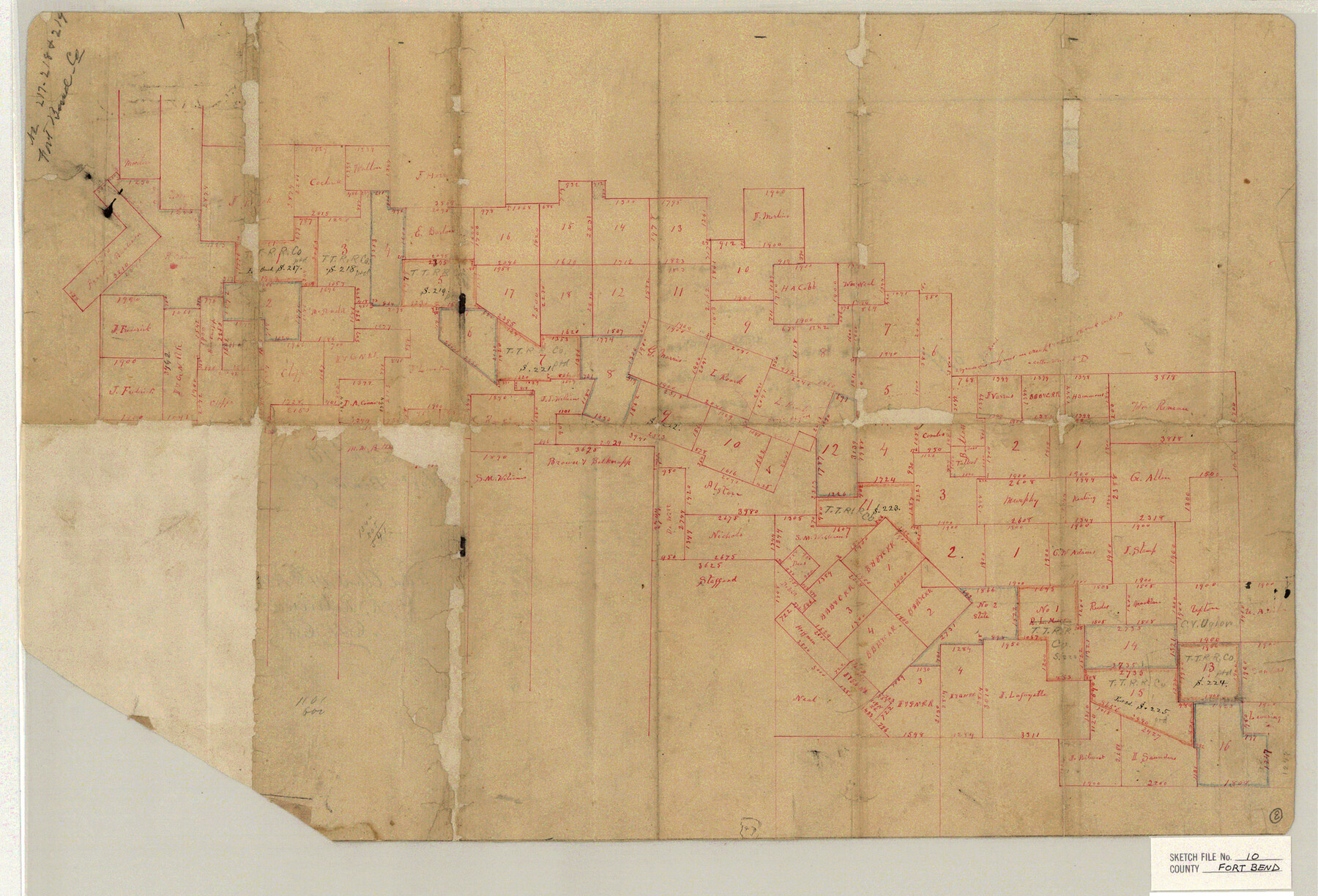
Fort Bend County Sketch File 10
[Sketch of surveys in the northeast part of Fort Bend County and southwest part of Harris County]
-
Map/Doc
11501
-
Collection
General Map Collection
-
Object Dates
4/14/1884 (File Date)
-
Counties
Fort Bend Harris
-
Subjects
Surveying Sketch File
-
Height x Width
16.9 x 24.9 inches
42.9 x 63.3 cm
-
Medium
paper, manuscript
Part of: General Map Collection
Newton County Working Sketch 18

Print $20.00
- Digital $50.00
Newton County Working Sketch 18
1950
Size 14.3 x 13.6 inches
Map/Doc 71264
Lubbock County Working Sketch 6

Print $20.00
- Digital $50.00
Lubbock County Working Sketch 6
1959
Size 25.1 x 22.4 inches
Map/Doc 70666
Bailey County Rolled Sketch 7

Print $40.00
- Digital $50.00
Bailey County Rolled Sketch 7
1941
Size 67.7 x 44.8 inches
Map/Doc 8438
Hopkins County Boundary File 3b

Print $4.00
- Digital $50.00
Hopkins County Boundary File 3b
Size 12.7 x 8.3 inches
Map/Doc 55084
Leon County Working Sketch 8

Print $20.00
- Digital $50.00
Leon County Working Sketch 8
1931
Size 28.9 x 42.8 inches
Map/Doc 70407
Flight Mission No. DQN-7K, Frame 14, Calhoun County

Print $20.00
- Digital $50.00
Flight Mission No. DQN-7K, Frame 14, Calhoun County
1953
Size 17.2 x 19.1 inches
Map/Doc 84465
Angelina County Sketch File 18b

Print $40.00
- Digital $50.00
Angelina County Sketch File 18b
Size 12.6 x 16.2 inches
Map/Doc 13032
Duval County Sketch File 84

Print $6.00
- Digital $50.00
Duval County Sketch File 84
1945
Size 14.4 x 8.9 inches
Map/Doc 21531
Cherokee County Sketch File 28

Print $6.00
- Digital $50.00
Cherokee County Sketch File 28
1916
Size 11.0 x 14.0 inches
Map/Doc 18173
Andrews County Rolled Sketch 6

Print $40.00
- Digital $50.00
Andrews County Rolled Sketch 6
1928
Size 43.9 x 56.9 inches
Map/Doc 8363
Dallam County Working Sketch Graphic Index

Print $40.00
- Digital $50.00
Dallam County Working Sketch Graphic Index
1926
Size 41.3 x 50.9 inches
Map/Doc 76516
Flight Mission No. CRE-2R, Frame 85, Jackson County

Print $20.00
- Digital $50.00
Flight Mission No. CRE-2R, Frame 85, Jackson County
1956
Size 18.4 x 22.3 inches
Map/Doc 85357
You may also like
Flight Mission No. CRK-7P, Frame 28, Refugio County

Print $20.00
- Digital $50.00
Flight Mission No. CRK-7P, Frame 28, Refugio County
1956
Size 18.4 x 22.1 inches
Map/Doc 86948
Map of City of Brownfield, Texas

Print $20.00
- Digital $50.00
Map of City of Brownfield, Texas
1953
Size 44.4 x 40.1 inches
Map/Doc 89890
Walker County Working Sketch 13

Print $20.00
- Digital $50.00
Walker County Working Sketch 13
1950
Size 18.0 x 16.6 inches
Map/Doc 72293
Hardin County Rolled Sketch 13

Print $20.00
- Digital $50.00
Hardin County Rolled Sketch 13
Size 36.0 x 42.3 inches
Map/Doc 9187
Flight Mission No. BQY-4M, Frame 55, Harris County

Print $20.00
- Digital $50.00
Flight Mission No. BQY-4M, Frame 55, Harris County
1953
Size 18.5 x 22.3 inches
Map/Doc 85264
General Highway Map. Detail of Cities and Towns in Dallas County, Texas [Dallas and vicinity]
![79067, General Highway Map. Detail of Cities and Towns in Dallas County, Texas [Dallas and vicinity], Texas State Library and Archives](https://historictexasmaps.com/wmedia_w700/maps/79067.tif.jpg)
Print $20.00
General Highway Map. Detail of Cities and Towns in Dallas County, Texas [Dallas and vicinity]
1936
Size 18.3 x 25.1 inches
Map/Doc 79067

Flight Mission No. DAG-23K, Frame 15, Matagorda County

Print $20.00
- Digital $50.00
Flight Mission No. DAG-23K, Frame 15, Matagorda County
1953
Size 15.5 x 15.3 inches
Map/Doc 86477
Gaines County Rolled Sketch 15

Print $40.00
- Digital $50.00
Gaines County Rolled Sketch 15
Size 73.5 x 23.4 inches
Map/Doc 9035
Duval County Working Sketch 7

Print $20.00
- Digital $50.00
Duval County Working Sketch 7
1935
Size 24.4 x 25.0 inches
Map/Doc 68720
Flight Mission No. DAH-9M, Frame 158, Orange County

Print $20.00
- Digital $50.00
Flight Mission No. DAH-9M, Frame 158, Orange County
1953
Size 18.4 x 22.3 inches
Map/Doc 86857
