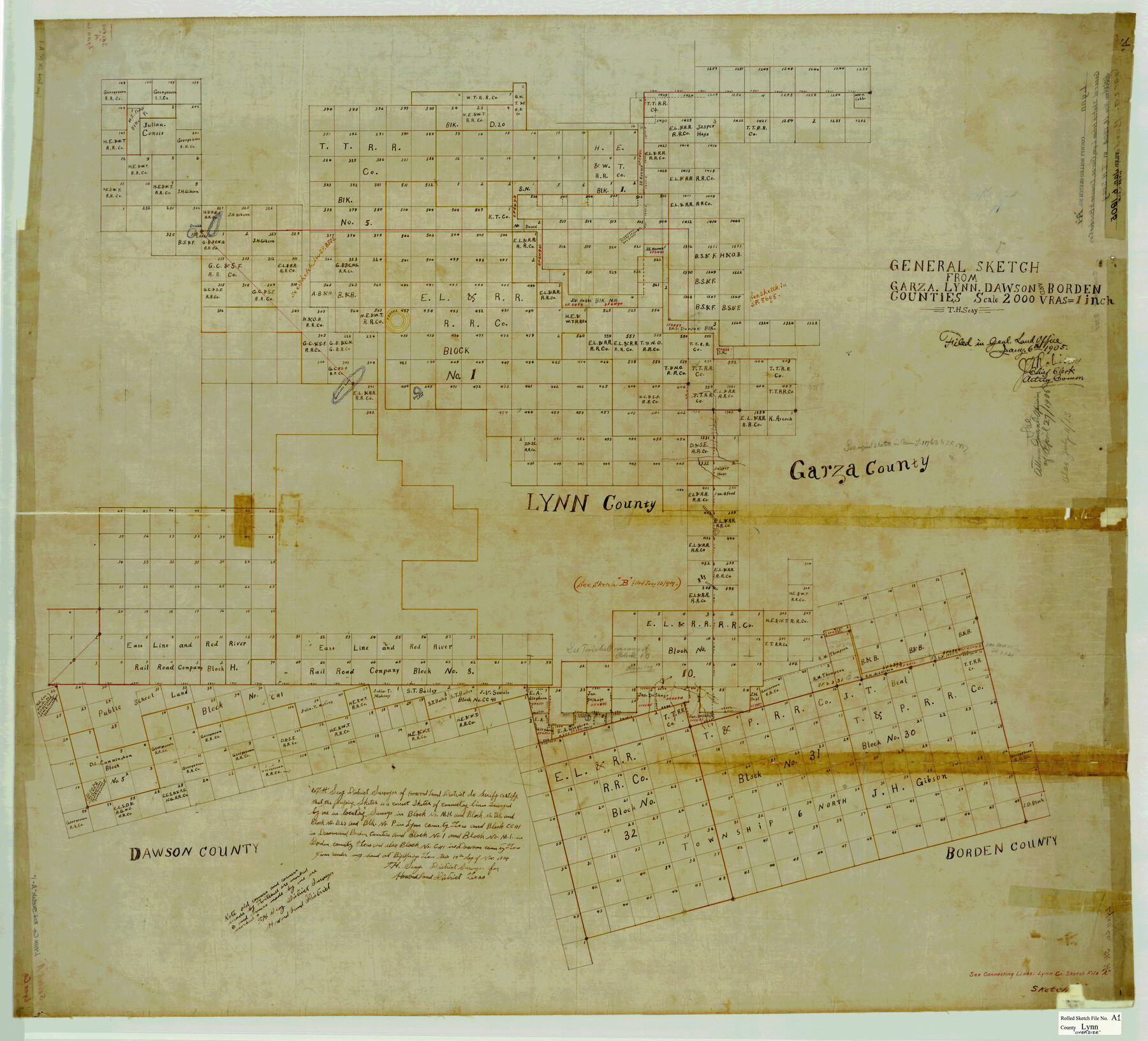
Lynn County Rolled Sketch A1
General sketch from Garza, Lynn, Dawson and Borden Counties
-
Map/Doc
8347
-
Collection
General Map Collection
-
Object Dates
1904/11/14 (Creation Date)
1905/1/6 (File Date)
-
People and Organizations
T.H. Seay (Surveyor/Engineer)
-
Counties
Lynn Garza Dawson Borden
-
Subjects
Surveying Rolled Sketch
-
Height x Width
39.2 x 43.3 inches
99.6 x 110.0 cm
-
Medium
linen, manuscript
-
Scale
1" = 2000 varas
-
Comments
See Lynn County Sketch File A (30477) for jacket, Lynn County Sketch Files A1 (30464), A2 (30470), and A3 (30473) for field notes, and Lynn County Rolled Sketch B (6653) for additional sketch.
Related maps
Lynn County Sketch File A1

Print $12.00
- Digital $50.00
Lynn County Sketch File A1
1903
Size 12.7 x 8.2 inches
Map/Doc 30464
Lynn County Sketch File A2

Print $6.00
- Digital $50.00
Lynn County Sketch File A2
1903
Size 12.7 x 8.0 inches
Map/Doc 30470
Lynn County Sketch File A3

Print $4.00
- Digital $50.00
Lynn County Sketch File A3
1904
Size 12.7 x 8.0 inches
Map/Doc 30473
Lynn County Sketch File A

Print $2.00
- Digital $50.00
Lynn County Sketch File A
1905
Size 8.6 x 6.3 inches
Map/Doc 30477
Lynn County Rolled Sketch B

Print $20.00
- Digital $50.00
Lynn County Rolled Sketch B
1908
Size 27.9 x 33.1 inches
Map/Doc 6653
Part of: General Map Collection
Flight Mission No. CRC-3R, Frame 200, Chambers County

Print $20.00
- Digital $50.00
Flight Mission No. CRC-3R, Frame 200, Chambers County
1956
Size 18.6 x 22.2 inches
Map/Doc 84855
Madison County Working Sketch 2

Print $20.00
- Digital $50.00
Madison County Working Sketch 2
1933
Size 23.4 x 25.5 inches
Map/Doc 70764
Map of Concho County

Print $20.00
- Digital $50.00
Map of Concho County
1879
Size 23.4 x 18.3 inches
Map/Doc 4523
Flight Mission No. CUG-2P, Frame 23, Kleberg County

Print $20.00
- Digital $50.00
Flight Mission No. CUG-2P, Frame 23, Kleberg County
1956
Size 18.6 x 22.3 inches
Map/Doc 86187
Bowie County Working Sketch 6

Print $20.00
- Digital $50.00
Bowie County Working Sketch 6
1928
Size 27.4 x 22.9 inches
Map/Doc 67410
Map of Nacogdoches County

Print $20.00
- Digital $50.00
Map of Nacogdoches County
1881
Size 24.1 x 21.5 inches
Map/Doc 4605
PSL Field Notes for Block A19 in Andrews County, C45 in Andrews and Gaines Counties, C31 in Dawson and Gaines Counties, C34 in Terry and Gaines Counties, C35 in Yoakum and Gaines Counties, and Blocks C30, C32, C33, C43, and C44 in Gaines County

PSL Field Notes for Block A19 in Andrews County, C45 in Andrews and Gaines Counties, C31 in Dawson and Gaines Counties, C34 in Terry and Gaines Counties, C35 in Yoakum and Gaines Counties, and Blocks C30, C32, C33, C43, and C44 in Gaines County
Map/Doc 81643
Flight Mission No. CUG-1P, Frame 55, Kleberg County

Print $20.00
- Digital $50.00
Flight Mission No. CUG-1P, Frame 55, Kleberg County
1956
Size 18.5 x 22.3 inches
Map/Doc 86133
No. 2 Chart of Corpus Christi Pass, Texas

Print $20.00
- Digital $50.00
No. 2 Chart of Corpus Christi Pass, Texas
1878
Size 18.3 x 27.4 inches
Map/Doc 73019
Duval County Sketch File 57

Print $14.00
- Digital $50.00
Duval County Sketch File 57
1939
Size 14.2 x 8.9 inches
Map/Doc 21418
Andrews County Sketch File 5

Print $4.00
- Digital $50.00
Andrews County Sketch File 5
1936
Size 11.8 x 8.8 inches
Map/Doc 12823
Flight Mission No. DCL-7C, Frame 139, Kenedy County

Print $20.00
- Digital $50.00
Flight Mission No. DCL-7C, Frame 139, Kenedy County
1943
Size 18.5 x 22.3 inches
Map/Doc 86096
You may also like
DeWitt County Working Sketch 3

Print $20.00
- Digital $50.00
DeWitt County Working Sketch 3
1957
Size 35.5 x 44.6 inches
Map/Doc 68593
Map showing eight tidal areas in Oso Bay and Oso Creek, Nueces County, Texas offered for Mineral Development

Print $20.00
- Digital $50.00
Map showing eight tidal areas in Oso Bay and Oso Creek, Nueces County, Texas offered for Mineral Development
1936
Size 17.9 x 29.7 inches
Map/Doc 2067
Fannin County Sketch File 12

Print $4.00
- Digital $50.00
Fannin County Sketch File 12
Size 8.4 x 6.5 inches
Map/Doc 22460
Chambers County Sketch File 11

Print $40.00
- Digital $50.00
Chambers County Sketch File 11
Size 13.7 x 12.6 inches
Map/Doc 17554
Potter County Rolled Sketch 3

Print $20.00
- Digital $50.00
Potter County Rolled Sketch 3
1892
Map/Doc 9758
Fisher County

Print $40.00
- Digital $50.00
Fisher County
1944
Size 50.2 x 44.2 inches
Map/Doc 95497
Harris County Rolled Sketch J

Print $40.00
- Digital $50.00
Harris County Rolled Sketch J
1933
Size 53.6 x 41.6 inches
Map/Doc 9122
Harris County Rolled Sketch 95

Print $20.00
- Digital $50.00
Harris County Rolled Sketch 95
1987
Size 34.2 x 27.8 inches
Map/Doc 6134
Garza County Sketch File B

Print $20.00
- Digital $50.00
Garza County Sketch File B
1898
Size 19.3 x 29.4 inches
Map/Doc 11549
Sutton County Sketch File 26

Print $20.00
- Digital $50.00
Sutton County Sketch File 26
1929
Size 19.6 x 14.8 inches
Map/Doc 12383
El Paso County Boundary File 6

Print $14.00
- Digital $50.00
El Paso County Boundary File 6
Size 14.0 x 8.8 inches
Map/Doc 53080
Flight Mission No. DAG-24K, Frame 51, Matagorda County

Print $20.00
- Digital $50.00
Flight Mission No. DAG-24K, Frame 51, Matagorda County
1953
Size 16.0 x 15.9 inches
Map/Doc 86538