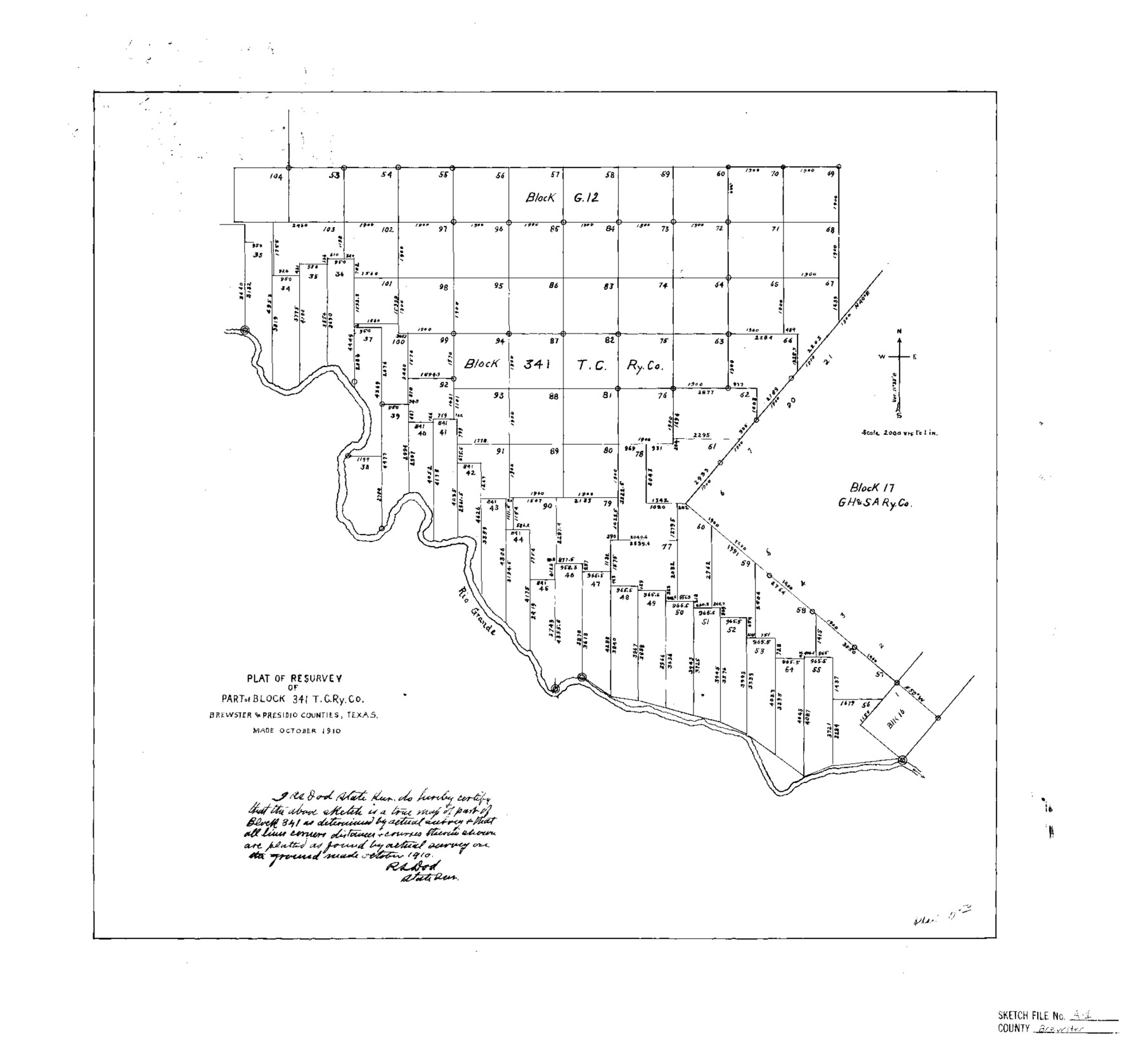
Brewster County Sketch File A
Plat of Resurvey of Part of Block 341, T. C. Ry. Co., Brewster & Presidio Counties, Texas
-
Map/Doc
10974
-
Collection
General Map Collection
-
Object Dates
1910 (Creation Date)
1911/7/29 (File Date)
-
People and Organizations
R.S. Dod (Surveyor/Engineer)
-
Counties
Brewster Presidio
-
Subjects
Surveying Sketch File
-
Height x Width
18.6 x 19.9 inches
47.2 x 50.5 cm
-
Medium
linen, manuscript
-
Scale
1" = 2000 varas
-
Comments
See Brewster County Sketch File A-1 (15712) for report.
-
Features
Rio Grande River
Related maps
Brewster County Sketch File A-1

Print $8.00
- Digital $50.00
Brewster County Sketch File A-1
1911
Size 14.2 x 8.7 inches
Map/Doc 15712
Part of: General Map Collection
Brewster County Rolled Sketch A

Print $40.00
- Digital $50.00
Brewster County Rolled Sketch A
Size 26.7 x 94.8 inches
Map/Doc 8925
Flight Mission No. DAG-24K, Frame 139, Matagorda County

Print $20.00
- Digital $50.00
Flight Mission No. DAG-24K, Frame 139, Matagorda County
1953
Size 18.5 x 22.3 inches
Map/Doc 86557
Presidio County Rolled Sketch 139

Print $20.00
- Digital $50.00
Presidio County Rolled Sketch 139
2002
Size 24.5 x 27.5 inches
Map/Doc 78647
Outer Continental Shelf Leasing Maps (Louisiana Offshore Operations)

Print $20.00
- Digital $50.00
Outer Continental Shelf Leasing Maps (Louisiana Offshore Operations)
1954
Size 21.2 x 16.3 inches
Map/Doc 76103
Reports of Committees, 23d Congress, 1st Session

Reports of Committees, 23d Congress, 1st Session
Size 9.2 x 6.0 inches
Map/Doc 95690
Flight Mission No. CRC-5R, Frame 20, Chambers County

Print $20.00
- Digital $50.00
Flight Mission No. CRC-5R, Frame 20, Chambers County
1956
Size 18.8 x 22.4 inches
Map/Doc 84942
Bandera County Working Sketch 53

Print $20.00
- Digital $50.00
Bandera County Working Sketch 53
1985
Size 34.0 x 36.0 inches
Map/Doc 67649
Jeff Davis County Rolled Sketch 20

Print $20.00
- Digital $50.00
Jeff Davis County Rolled Sketch 20
1944
Size 22.7 x 19.6 inches
Map/Doc 7724
King County Working Sketch 4

Print $20.00
- Digital $50.00
King County Working Sketch 4
1939
Size 42.9 x 25.7 inches
Map/Doc 70168
Flight Mission No. BRE-2P, Frame 74, Nueces County

Print $20.00
- Digital $50.00
Flight Mission No. BRE-2P, Frame 74, Nueces County
1956
Size 18.5 x 22.3 inches
Map/Doc 86769
Randall County

Print $20.00
- Digital $50.00
Randall County
1879
Size 21.4 x 19.2 inches
Map/Doc 3974
Harris County Working Sketch 7

Print $20.00
- Digital $50.00
Harris County Working Sketch 7
1900
Size 34.2 x 28.6 inches
Map/Doc 65899
You may also like
Sketch of 103rd Meridian, W. L. Showing Conflict of Capitol Leagues

Print $40.00
- Digital $50.00
Sketch of 103rd Meridian, W. L. Showing Conflict of Capitol Leagues
Size 26.9 x 85.1 inches
Map/Doc 65505
Leon County Rolled Sketch 24

Print $20.00
- Digital $50.00
Leon County Rolled Sketch 24
1986
Size 34.7 x 39.6 inches
Map/Doc 6610
Right of Way & Track Map, St. Louis, Brownsville & Mexico Ry. operated by St. Louis, Brownsville & Mexico Ry. Co.

Print $40.00
- Digital $50.00
Right of Way & Track Map, St. Louis, Brownsville & Mexico Ry. operated by St. Louis, Brownsville & Mexico Ry. Co.
1919
Size 25.5 x 57.1 inches
Map/Doc 64615
Map of the City of San Antonio, Bexar County, Texas including suburbs, north and south

Print $20.00
- Digital $50.00
Map of the City of San Antonio, Bexar County, Texas including suburbs, north and south
Size 39.6 x 26.6 inches
Map/Doc 96511
Survey of 77 Blocks, State University Land

Survey of 77 Blocks, State University Land
1884
Size 13.5 x 8.5 inches
Map/Doc 81693
Nolan County Sketch File 12

Print $20.00
- Digital $50.00
Nolan County Sketch File 12
1924
Size 22.5 x 24.5 inches
Map/Doc 42163
Kinney County Working Sketch 9

Print $20.00
- Digital $50.00
Kinney County Working Sketch 9
1918
Size 20.4 x 20.4 inches
Map/Doc 70191
[Worksheets related to the Wilson Strickland survey and vicinity]
![91267, [Vicinity and related to the Wilson Strickland Survey], Twichell Survey Records](https://historictexasmaps.com/wmedia_w700/maps/91267-1.tif.jpg)
Print $20.00
- Digital $50.00
[Worksheets related to the Wilson Strickland survey and vicinity]
Size 21.7 x 19.4 inches
Map/Doc 91267
Cochran County Sketch File 2

Print $22.00
- Digital $50.00
Cochran County Sketch File 2
1907
Size 4.4 x 13.6 inches
Map/Doc 18539
Wheeler County Sketch File 11

Print $47.00
- Digital $50.00
Wheeler County Sketch File 11
1992
Size 11.5 x 9.0 inches
Map/Doc 40014
Ector County Working Sketch 27

Print $20.00
- Digital $50.00
Ector County Working Sketch 27
Size 28.0 x 32.7 inches
Map/Doc 68870
Brewster County Rolled Sketch 83A

Print $40.00
- Digital $50.00
Brewster County Rolled Sketch 83A
1946
Size 43.0 x 49.5 inches
Map/Doc 8930