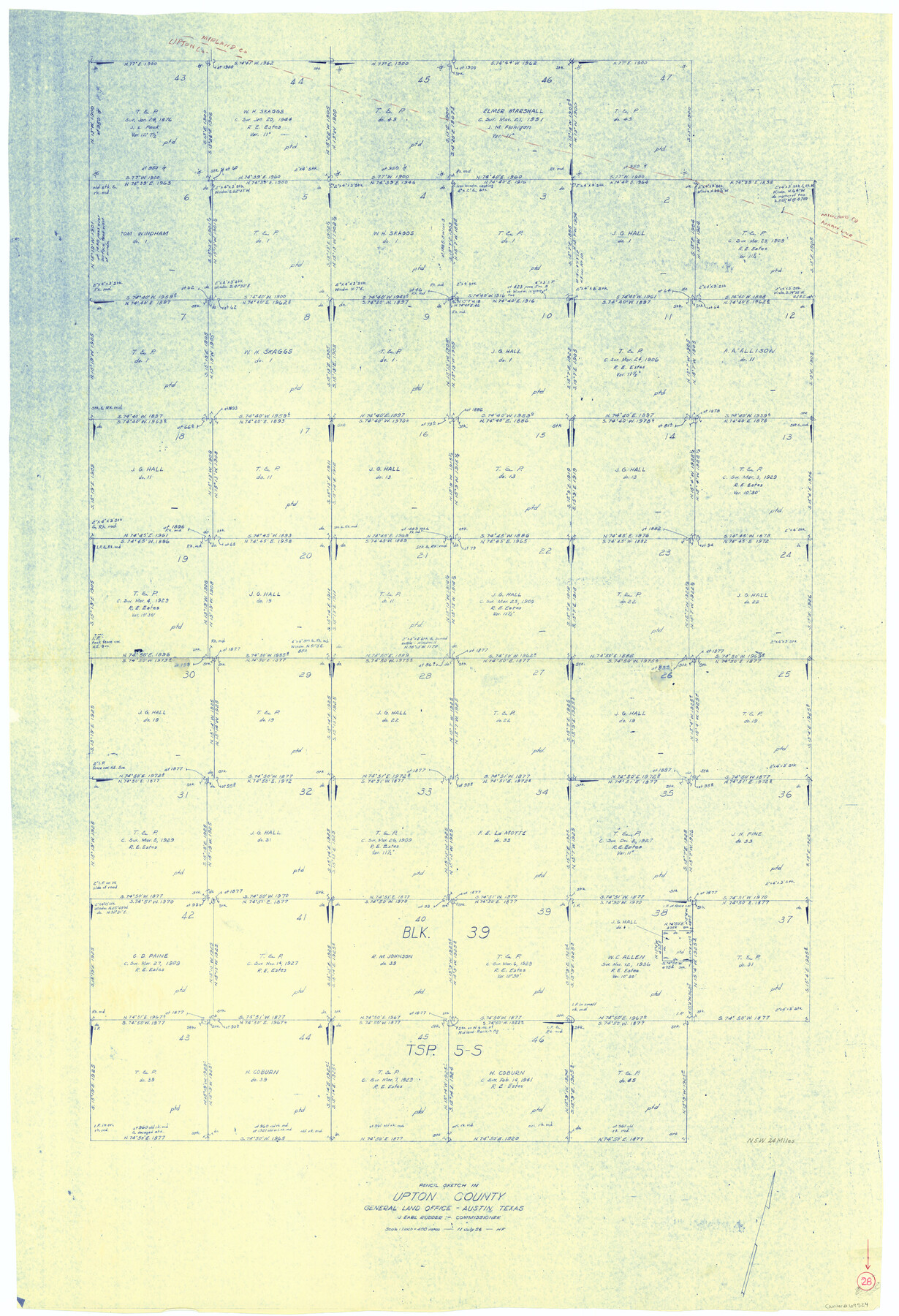
Upton County Working Sketch 28
-
Map/Doc
69524
-
Collection
General Map Collection
-
Object Dates
7/11/1956 (Creation Date)
-
People and Organizations
Herman Forbes (Draftsman)
-
Counties
Upton
-
Subjects
Surveying Working Sketch
-
Height x Width
52.5 x 35.9 inches
133.4 x 91.2 cm
-
Scale
1" = 400 varas
Part of: General Map Collection
Polk County Sketch File 44

Print $193.00
- Digital $50.00
Polk County Sketch File 44
1958
Size 9.4 x 11.0 inches
Map/Doc 34297
Geographical, Statistical, and Historical Map of the District of Columbia

Print $20.00
- Digital $50.00
Geographical, Statistical, and Historical Map of the District of Columbia
Size 18.0 x 22.4 inches
Map/Doc 97102
Map of Part of Espiritu Santo and San Antonio Bays and Vicinity, Texas

Print $40.00
- Digital $50.00
Map of Part of Espiritu Santo and San Antonio Bays and Vicinity, Texas
1859
Size 31.6 x 53.1 inches
Map/Doc 69983
Rusk County Rolled Sketch 6

Print $20.00
- Digital $50.00
Rusk County Rolled Sketch 6
1949
Size 33.7 x 26.6 inches
Map/Doc 7543
San Patricio County Working Sketch 7

Print $20.00
- Digital $50.00
San Patricio County Working Sketch 7
1936
Size 18.3 x 15.9 inches
Map/Doc 63769
Flight Mission No. BRA-17M, Frame 14, Jefferson County

Print $20.00
- Digital $50.00
Flight Mission No. BRA-17M, Frame 14, Jefferson County
1953
Size 18.5 x 22.3 inches
Map/Doc 85795
Stonewall County Working Sketch 33

Print $40.00
- Digital $50.00
Stonewall County Working Sketch 33
1984
Size 70.4 x 42.8 inches
Map/Doc 62340
Johnson County

Print $20.00
- Digital $50.00
Johnson County
1943
Size 39.8 x 37.0 inches
Map/Doc 77332
Goliad County Working Sketch 9

Print $20.00
- Digital $50.00
Goliad County Working Sketch 9
1938
Size 19.3 x 27.6 inches
Map/Doc 63199
Flight Mission No. CRC-4R, Frame 80, Chambers County

Print $20.00
- Digital $50.00
Flight Mission No. CRC-4R, Frame 80, Chambers County
1956
Size 18.6 x 22.4 inches
Map/Doc 84884
Medina County Working Sketch 18

Print $20.00
- Digital $50.00
Medina County Working Sketch 18
1980
Size 31.4 x 38.0 inches
Map/Doc 70933
Right of Way and Track Map of The Missouri, Kansas & Texas Railway of Texas

Print $40.00
- Digital $50.00
Right of Way and Track Map of The Missouri, Kansas & Texas Railway of Texas
1918
Size 25.2 x 106.9 inches
Map/Doc 64531
You may also like


Hardin County Sketch File 29

Print $4.00
- Digital $50.00
Hardin County Sketch File 29
Size 8.1 x 11.8 inches
Map/Doc 25155
[Sketch for Mineral Application 26542 - Sabine River between Prairie and Hawkins Creek, F. B. Jackson, Jr.]
![65670, [Sketch for Mineral Application 26542 - Sabine River between Prairie and Hawkins Creek, F. B. Jackson, Jr.], General Map Collection](https://historictexasmaps.com/wmedia_w700/maps/65670.tif.jpg)
Print $40.00
- Digital $50.00
[Sketch for Mineral Application 26542 - Sabine River between Prairie and Hawkins Creek, F. B. Jackson, Jr.]
1931
Size 64.4 x 21.0 inches
Map/Doc 65670
El Paso County Rolled Sketch 54

Print $20.00
- Digital $50.00
El Paso County Rolled Sketch 54
1980
Size 30.4 x 42.8 inches
Map/Doc 44539
Flight Mission No. BRA-3M, Frame 197, Jefferson County

Print $20.00
- Digital $50.00
Flight Mission No. BRA-3M, Frame 197, Jefferson County
1953
Size 18.6 x 22.4 inches
Map/Doc 85412
Cottle County Sketch File 4

Print $16.00
- Digital $50.00
Cottle County Sketch File 4
Size 8.2 x 4.2 inches
Map/Doc 19466
Atascosa County Rolled Sketch 21

Print $20.00
- Digital $50.00
Atascosa County Rolled Sketch 21
1958
Size 25.0 x 38.0 inches
Map/Doc 5100
Crockett County Sketch File 78

Print $20.00
- Digital $50.00
Crockett County Sketch File 78
1931
Size 29.4 x 19.1 inches
Map/Doc 11235
Deaf Smith County Sketch File 1b

Print $24.00
- Digital $50.00
Deaf Smith County Sketch File 1b
1902
Size 11.3 x 8.9 inches
Map/Doc 20627
Map of Eastland Co.

Print $20.00
- Digital $50.00
Map of Eastland Co.
1896
Size 40.8 x 43.8 inches
Map/Doc 66809
Liberty County Working Sketch 33

Print $20.00
- Digital $50.00
Liberty County Working Sketch 33
1954
Size 30.6 x 36.7 inches
Map/Doc 70492