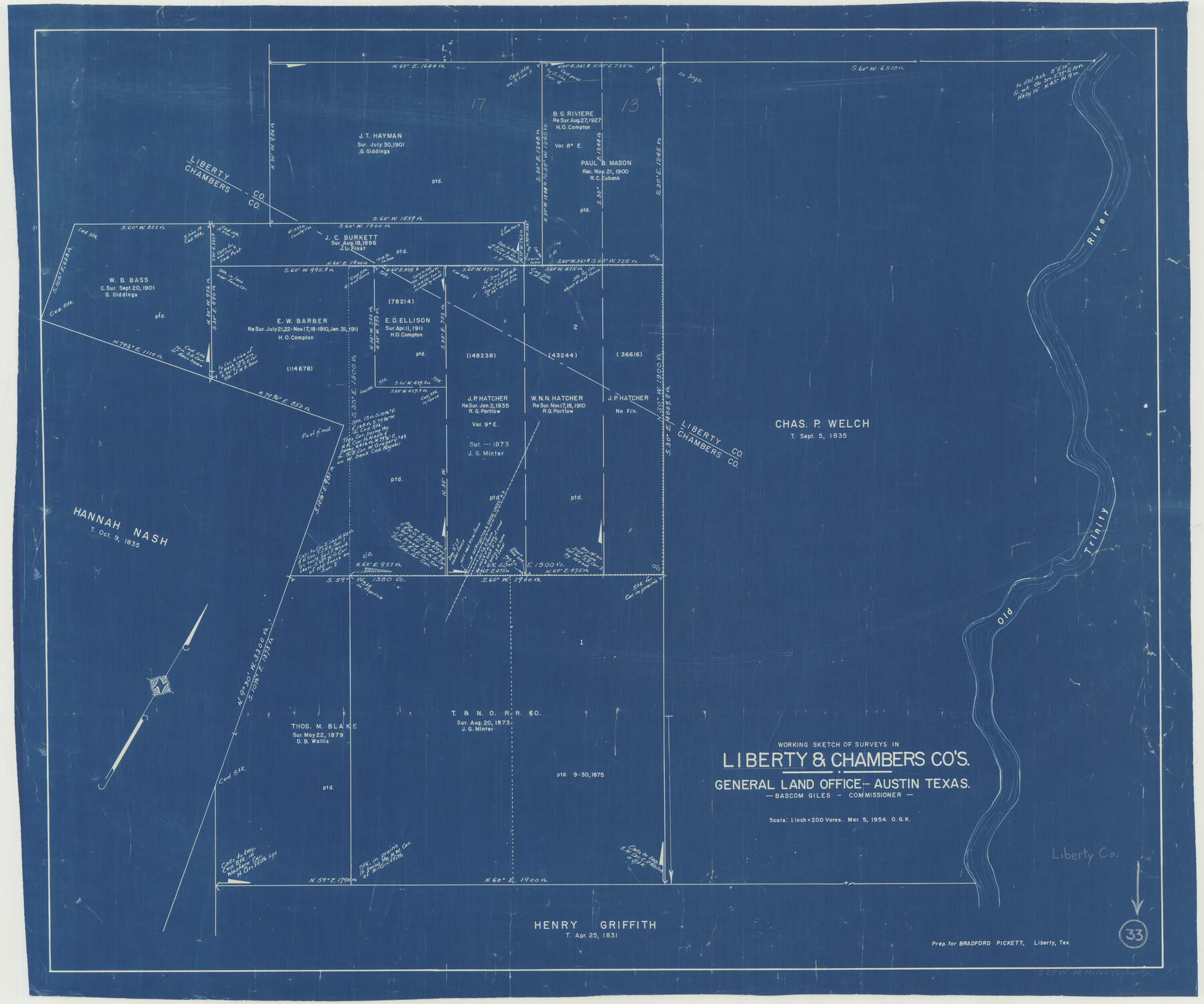
Liberty County Working Sketch 33
-
Map/Doc
70492
-
Collection
General Map Collection
-
Object Dates
3/5/1954 (Creation Date)
-
People and Organizations
Otto G. Kurio (Draftsman)
-
Counties
Liberty Chambers
-
Subjects
Surveying Working Sketch
-
Height x Width
30.6 x 36.7 inches
77.7 x 93.2 cm
-
Scale
1" = 200 varas
Part of: General Map Collection
Gregg County Rolled Sketch RGA

Print $46.00
- Digital $50.00
Gregg County Rolled Sketch RGA
1933
Size 34.3 x 30.6 inches
Map/Doc 9026
Tyler County Sketch File 1

Print $22.00
- Digital $50.00
Tyler County Sketch File 1
1849
Size 12.2 x 15.3 inches
Map/Doc 38607
Burleson County Working Sketch 5

Print $20.00
- Digital $50.00
Burleson County Working Sketch 5
1980
Size 34.8 x 27.6 inches
Map/Doc 67724
Improving Sabine Pass, Texas. Surveyed May 10th to June 30th, 1894 under the direction of Major James B. Quinn, Corps of Engineers, USA

Print $20.00
- Digital $50.00
Improving Sabine Pass, Texas. Surveyed May 10th to June 30th, 1894 under the direction of Major James B. Quinn, Corps of Engineers, USA
1894
Size 9.3 x 13.2 inches
Map/Doc 94155
King County Rolled Sketch 8

Print $20.00
- Digital $50.00
King County Rolled Sketch 8
1902
Size 34.8 x 29.8 inches
Map/Doc 6531
[Beaumont, Sour Lake and Western Ry. Right of Way and Alignment - Frisco]
![64125, [Beaumont, Sour Lake and Western Ry. Right of Way and Alignment - Frisco], General Map Collection](https://historictexasmaps.com/wmedia_w700/maps/64125.tif.jpg)
Print $20.00
- Digital $50.00
[Beaumont, Sour Lake and Western Ry. Right of Way and Alignment - Frisco]
1910
Size 20.1 x 45.9 inches
Map/Doc 64125
Kendall County Rolled Sketch 3

Print $9.00
- Digital $50.00
Kendall County Rolled Sketch 3
1858
Size 10.0 x 15.3 inches
Map/Doc 46424
Nueces County Rolled Sketch 113B

Print $20.00
- Digital $50.00
Nueces County Rolled Sketch 113B
1972
Size 18.6 x 24.2 inches
Map/Doc 7123
Crockett County Rolled Sketch 37

Print $20.00
- Digital $50.00
Crockett County Rolled Sketch 37
Size 36.7 x 29.3 inches
Map/Doc 5589
Nueces County Working Sketch 3

Print $20.00
- Digital $50.00
Nueces County Working Sketch 3
1972
Size 38.9 x 45.0 inches
Map/Doc 71305
[Sketch for Mineral Application 33721 - 33725 Incl. - Padre and Mustang Island]
![2870, [Sketch for Mineral Application 33721 - 33725 Incl. - Padre and Mustang Island], General Map Collection](https://historictexasmaps.com/wmedia_w700/maps/2870.tif.jpg)
Print $20.00
- Digital $50.00
[Sketch for Mineral Application 33721 - 33725 Incl. - Padre and Mustang Island]
1942
Size 22.1 x 22.4 inches
Map/Doc 2870
Montague County Sketch File 23

Print $6.00
- Digital $50.00
Montague County Sketch File 23
1941
Size 13.9 x 8.4 inches
Map/Doc 31753
You may also like
[Blocks 242, 243, and 244]
![90999, [Blocks 242, 243, and 244], Twichell Survey Records](https://historictexasmaps.com/wmedia_w700/maps/90999-1.tif.jpg)
Print $2.00
- Digital $50.00
[Blocks 242, 243, and 244]
Size 9.2 x 14.8 inches
Map/Doc 90999
Fractional Township No. 10 South Range No. 26 East of the Indian Meridian, Indian Territory

Print $20.00
- Digital $50.00
Fractional Township No. 10 South Range No. 26 East of the Indian Meridian, Indian Territory
1897
Size 19.2 x 24.3 inches
Map/Doc 75245
Archer County Sketch File 26

Print $4.00
- Digital $50.00
Archer County Sketch File 26
1934
Size 9.7 x 4.4 inches
Map/Doc 13663
Roberts County Sketch File 7

Print $16.00
- Digital $50.00
Roberts County Sketch File 7
1992
Size 14.3 x 8.8 inches
Map/Doc 35316
Brooks County Sketch File 4

Print $4.00
- Digital $50.00
Brooks County Sketch File 4
Size 14.3 x 8.7 inches
Map/Doc 16549
Waco, Tex., County Seat of McLennan Co.

Print $20.00
Waco, Tex., County Seat of McLennan Co.
1886
Size 23.1 x 32.7 inches
Map/Doc 89212
Culberson County Sketch File 2

Print $20.00
- Digital $50.00
Culberson County Sketch File 2
1882
Size 28.9 x 36.4 inches
Map/Doc 11261
[G. C. & S. F. Railroad Company Block H2, Town of Adrian, and Vicinity]
![91439, [G. C. & S. F. Railroad Company Block H2, Town of Adrian, and Vicinity], Twichell Survey Records](https://historictexasmaps.com/wmedia_w700/maps/91439-1.tif.jpg)
Print $20.00
- Digital $50.00
[G. C. & S. F. Railroad Company Block H2, Town of Adrian, and Vicinity]
Size 24.4 x 15.8 inches
Map/Doc 91439
[Nathaniel H. Cochran Survey and Vicinity]
![91494, [Nathaniel H. Cochran Survey and Vicinity], Twichell Survey Records](https://historictexasmaps.com/wmedia_w700/maps/91494-1.tif.jpg)
Print $20.00
- Digital $50.00
[Nathaniel H. Cochran Survey and Vicinity]
Size 26.7 x 18.8 inches
Map/Doc 91494
Hansford County, Texas

Print $20.00
- Digital $50.00
Hansford County, Texas
1888
Size 22.6 x 18.6 inches
Map/Doc 5033
Southern Pacific R.R. and connections

Print $20.00
- Digital $50.00
Southern Pacific R.R. and connections
1883
Size 27.9 x 32.5 inches
Map/Doc 94270
Collin County Working Sketch 1

Print $20.00
- Digital $50.00
Collin County Working Sketch 1
1921
Size 26.6 x 23.4 inches
Map/Doc 68095