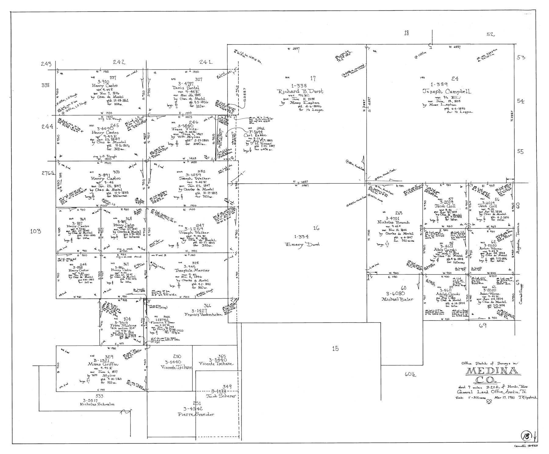
Medina County Working Sketch 18
-
Map/Doc
70933
-
Collection
General Map Collection
-
Object Dates
3/17/1980 (Creation Date)
-
People and Organizations
Joan Kilpatrick (Draftsman)
-
Counties
Medina
-
Subjects
Surveying Working Sketch
-
Height x Width
31.4 x 38.0 inches
79.8 x 96.5 cm
-
Scale
1" = 300 varas
Part of: General Map Collection
Val Verde County Working Sketch Graphic Index, Sheet 2 (Sketches 26 to 88)

Print $20.00
- Digital $50.00
Val Verde County Working Sketch Graphic Index, Sheet 2 (Sketches 26 to 88)
1944
Size 40.3 x 36.4 inches
Map/Doc 76725
[Sketch of Surveys on Big Sandy Creek]
![179, [Sketch of Surveys on Big Sandy Creek], General Map Collection](https://historictexasmaps.com/wmedia_w700/maps/179.tif.jpg)
Print $2.00
- Digital $50.00
[Sketch of Surveys on Big Sandy Creek]
1841
Size 8.2 x 9.2 inches
Map/Doc 179
Pecos County Sketch File 42

Print $30.00
- Digital $50.00
Pecos County Sketch File 42
1919
Size 9.1 x 8.0 inches
Map/Doc 33735
San Augustine County Rolled Sketch 1

Print $20.00
- Digital $50.00
San Augustine County Rolled Sketch 1
Size 16.6 x 13.8 inches
Map/Doc 7552
Goliad County Working Sketch 4

Print $20.00
- Digital $50.00
Goliad County Working Sketch 4
1920
Size 30.5 x 30.0 inches
Map/Doc 63194

Potter County Sketch File 15

Print $20.00
- Digital $50.00
Potter County Sketch File 15
Size 19.5 x 21.1 inches
Map/Doc 12201
Henderson County Working Sketch 24

Print $20.00
- Digital $50.00
Henderson County Working Sketch 24
1952
Size 29.3 x 22.9 inches
Map/Doc 66157

Presidio County Working Sketch 13

Print $20.00
- Digital $50.00
Presidio County Working Sketch 13
1941
Size 25.7 x 41.5 inches
Map/Doc 71689
Map of the United States, Canada and a part of Mexico to illustrate Olney's school geography

Print $20.00
- Digital $50.00
Map of the United States, Canada and a part of Mexico to illustrate Olney's school geography
1844
Size 12.1 x 19.0 inches
Map/Doc 93537
Chambers County Sketch File 56

Print $7.00
- Digital $50.00
Chambers County Sketch File 56
Size 14.8 x 8.7 inches
Map/Doc 18099
You may also like
Orange County Working Sketch 8

Print $20.00
- Digital $50.00
Orange County Working Sketch 8
1922
Size 20.7 x 24.3 inches
Map/Doc 71340
Right of Way and Track Map, The Missouri, Kansas and Texas Ry. of Texas operated by the Missouri, Kansas and Texas Ry. of Texas, Henrietta Division

Print $40.00
- Digital $50.00
Right of Way and Track Map, The Missouri, Kansas and Texas Ry. of Texas operated by the Missouri, Kansas and Texas Ry. of Texas, Henrietta Division
1918
Size 25.5 x 56.6 inches
Map/Doc 64070
Flight Mission No. CLL-1N, Frame 109, Willacy County

Print $20.00
- Digital $50.00
Flight Mission No. CLL-1N, Frame 109, Willacy County
1954
Size 18.3 x 22.1 inches
Map/Doc 87043

No. 3 Chart of Channel connecting Corpus Christi Bay with Aransas Bay, Texas

Print $20.00
- Digital $50.00
No. 3 Chart of Channel connecting Corpus Christi Bay with Aransas Bay, Texas
1878
Size 18.3 x 27.9 inches
Map/Doc 72783
Baylor County Rolled Sketch BHK

Print $20.00
- Digital $50.00
Baylor County Rolled Sketch BHK
1892
Size 18.8 x 43.5 inches
Map/Doc 5130
Presidio County Sketch File 64

Print $20.00
- Digital $50.00
Presidio County Sketch File 64
1938
Size 16.5 x 26.5 inches
Map/Doc 11719
Motley County Sketch File 35 (S)

Print $20.00
- Digital $50.00
Motley County Sketch File 35 (S)
Size 17.8 x 18.5 inches
Map/Doc 42150
San Patricio County Working Sketch 16

Print $20.00
- Digital $50.00
San Patricio County Working Sketch 16
1952
Size 41.6 x 32.1 inches
Map/Doc 63778
Sterling County Rolled Sketch 33

Print $20.00
- Digital $50.00
Sterling County Rolled Sketch 33
Size 16.6 x 12.3 inches
Map/Doc 7857
Rio Grande, Fernando Sheet

Print $4.00
- Digital $50.00
Rio Grande, Fernando Sheet
1935
Size 20.8 x 25.8 inches
Map/Doc 65114
Nolan County Working Sketch 2

Print $20.00
- Digital $50.00
Nolan County Working Sketch 2
1943
Size 26.7 x 25.0 inches
Map/Doc 71293