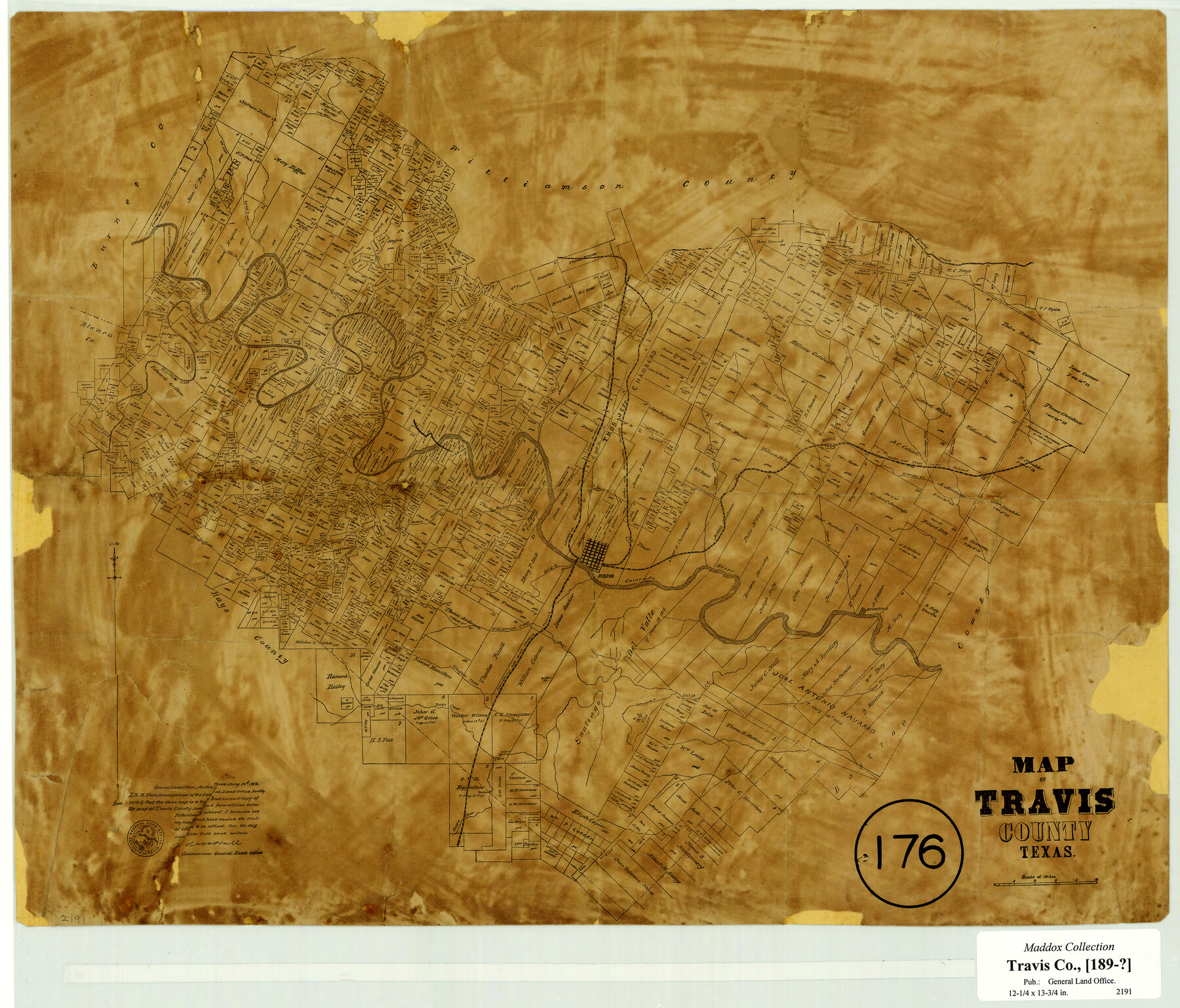
Map of Travis County, Texas
-
Map/Doc
556
-
Collection
Maddox Collection
-
Object Dates
1890 (Creation Date)
-
People and Organizations
General Land Office (Publisher)
R.M. Hall (GLO Commissioner)
-
Counties
Travis Hays
-
Subjects
County
-
Height x Width
13.7 x 17.1 inches
34.8 x 43.4 cm
-
Scale
1:4000
-
Comments
Adopted by students in Buck Cole's honors history classes at Sam L. Martin Middle School and conservation funded in 2005.
-
Features
Williamson Creek
Bartons Creek
Flint Rock P.O.
Bee Creek
Shoal Creek
Gilelands Creek
Colorado River
Austin
Spring Creek
Grape Creek
Webberville
Bee Cave P.O.
Oatman P.O.
Slaughter Creek
Bear Creek
Pilot Knob
Cottonmouth Creek
Onion Creek
Cedar Creek
Onion Creek P.O.
Manchaca
Harriss [sic] Branch [of Gillelands Creek]
Long Hollow
Cross Creek
Brushy Creek
Flat Creek
Post Oak Creek
Pedernales River
Dell Creek
Duval
H&TC
Manor
Cow Creek
Bull Creek
Elm Creek
Wilbarger Creek
Walnut Creek
A&NW
I&GN
Honey Creek
Shingle Hills
Palmers Creek
Part of: Maddox Collection
[Vague Sketches in Brooks County, Texas]
![83352, [Vague Sketches in Brooks County, Texas], Maddox Collection](https://historictexasmaps.com/wmedia_w700/maps/83352.tif.jpg)
Print $20.00
- Digital $50.00
[Vague Sketches in Brooks County, Texas]
1906
Size 17.8 x 19.9 inches
Map/Doc 83352
Randall County, Texas

Print $20.00
- Digital $50.00
Randall County, Texas
1887
Size 19.4 x 16.7 inches
Map/Doc 747
Sketch showing OX lands in the Yarbrough Pasture

Print $20.00
- Digital $50.00
Sketch showing OX lands in the Yarbrough Pasture
Size 14.0 x 25.2 inches
Map/Doc 4433
[Sketch of H & T C RR Co. Blocks north of the Canadian River, Hemphill County, Texas]
![10758, [Sketch of H & T C RR Co. Blocks north of the Canadian River, Hemphill County, Texas], Maddox Collection](https://historictexasmaps.com/wmedia_w700/maps/10758-GC.tif.jpg)
Print $3.00
- Digital $50.00
[Sketch of H & T C RR Co. Blocks north of the Canadian River, Hemphill County, Texas]
Size 10.4 x 16.1 inches
Map/Doc 10758
[Wm. B. Jaques assee. of José Pineda, Kimble County, Texas]
![540, [Wm. B. Jaques assee. of José Pineda, Kimble County, Texas], Maddox Collection](https://historictexasmaps.com/wmedia_w700/maps/0540.tif.jpg)
Print $3.00
- Digital $50.00
[Wm. B. Jaques assee. of José Pineda, Kimble County, Texas]
Size 16.1 x 11.2 inches
Map/Doc 540
"La Gloria Ranch", Duval Co. Texas

Print $20.00
- Digital $50.00
"La Gloria Ranch", Duval Co. Texas
Size 12.0 x 15.1 inches
Map/Doc 431
Map of Part of the YL Ranch

Print $20.00
- Digital $50.00
Map of Part of the YL Ranch
1917
Size 29.1 x 27.3 inches
Map/Doc 4442
Haskell County
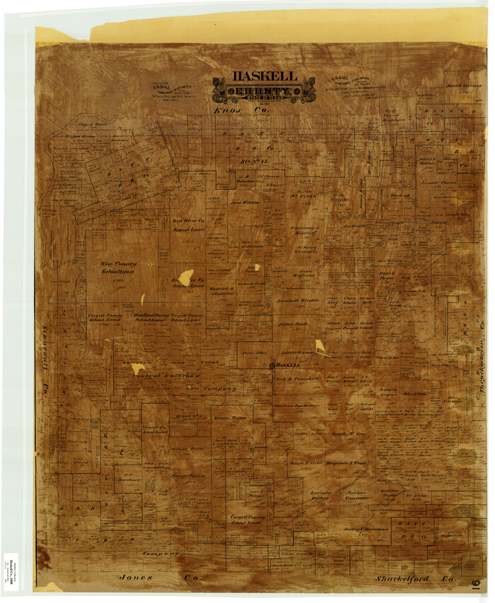
Print $20.00
- Digital $50.00
Haskell County
1888
Size 41.4 x 33.9 inches
Map/Doc 399
[Sketch of Surveys in Cottle, Dickens, King & Motley Counties, Texas]
![75830, [Sketch of Surveys in Cottle, Dickens, King & Motley Counties, Texas], Maddox Collection](https://historictexasmaps.com/wmedia_w700/maps/75830.tif.jpg)
Print $20.00
- Digital $50.00
[Sketch of Surveys in Cottle, Dickens, King & Motley Counties, Texas]
1913
Size 29.6 x 23.2 inches
Map/Doc 75830
Map of Shackelford County, Texas

Print $20.00
- Digital $50.00
Map of Shackelford County, Texas
1879
Size 28.7 x 23.4 inches
Map/Doc 616
Montgomery County, Texas

Print $20.00
- Digital $50.00
Montgomery County, Texas
1880
Size 24.6 x 27.6 inches
Map/Doc 582
Map showing lands of D. Sullivan situated in Starr County, Texas

Print $20.00
- Digital $50.00
Map showing lands of D. Sullivan situated in Starr County, Texas
Size 15.5 x 18.6 inches
Map/Doc 755
You may also like
Flight Mission No. BQY-4M, Frame 59, Harris County

Print $20.00
- Digital $50.00
Flight Mission No. BQY-4M, Frame 59, Harris County
1953
Size 18.5 x 22.3 inches
Map/Doc 85268
Gulf, Texas & Western Railway

Print $40.00
- Digital $50.00
Gulf, Texas & Western Railway
1913
Size 19.4 x 61.3 inches
Map/Doc 64440
Motley County Sketch File 2D (N)

Print $20.00
- Digital $50.00
Motley County Sketch File 2D (N)
Size 14.3 x 9.0 inches
Map/Doc 31984
Flight Mission No. CON-2R, Frame 114, Stonewall County

Print $20.00
- Digital $50.00
Flight Mission No. CON-2R, Frame 114, Stonewall County
1957
Size 18.3 x 22.0 inches
Map/Doc 86989
Flight Mission No. CZW-1R, Frame 165, Hardeman County

Print $20.00
- Digital $50.00
Flight Mission No. CZW-1R, Frame 165, Hardeman County
1956
Size 18.7 x 22.4 inches
Map/Doc 85236
Brewster County Working Sketch 87

Print $40.00
- Digital $50.00
Brewster County Working Sketch 87
1973
Size 37.4 x 56.6 inches
Map/Doc 67687
Frio County Rolled Sketch HM2

Print $20.00
- Digital $50.00
Frio County Rolled Sketch HM2
1935
Size 41.3 x 30.6 inches
Map/Doc 8899
Upton County Working Sketch 28

Print $40.00
- Digital $50.00
Upton County Working Sketch 28
1956
Size 52.5 x 35.9 inches
Map/Doc 69524
Township 15 South Range 15 West and Fractional Township 16 South Range 15 West, South Western District, Louisiana

Print $20.00
- Digital $50.00
Township 15 South Range 15 West and Fractional Township 16 South Range 15 West, South Western District, Louisiana
1875
Size 19.6 x 24.7 inches
Map/Doc 65861
Midland County Sketch File 9

Print $20.00
- Digital $50.00
Midland County Sketch File 9
Size 19.7 x 29.2 inches
Map/Doc 12085
Colorado County Rolled Sketch 1

Print $20.00
- Digital $50.00
Colorado County Rolled Sketch 1
1940
Size 37.6 x 35.5 inches
Map/Doc 8640
Erath County Working Sketch 4

Print $20.00
- Digital $50.00
Erath County Working Sketch 4
1919
Size 31.7 x 28.6 inches
Map/Doc 69085