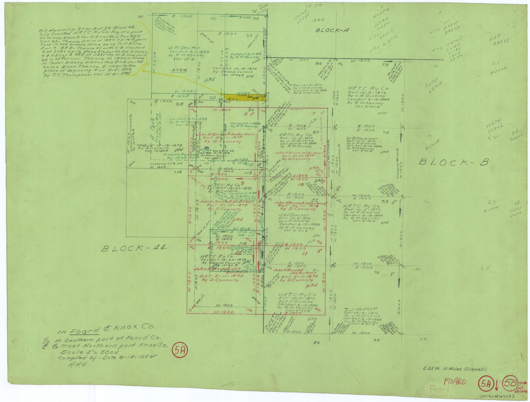
Foard County Working Sketch 5a
-
Map/Doc
69195
-
Collection
General Map Collection
-
Object Dates
8/14/1942 (Creation Date)
-
People and Organizations
Herbert H. Ulbricht (Draftsman)
-
Counties
Foard Knox
-
Subjects
Surveying Working Sketch
-
Height x Width
18.4 x 24.2 inches
46.7 x 61.5 cm
-
Scale
1" = 600 varas
Part of: General Map Collection
Mosaic composed of aerial photographs - Houston Ship Channel, Tex.

Print $20.00
- Digital $50.00
Mosaic composed of aerial photographs - Houston Ship Channel, Tex.
1923
Size 13.7 x 38.0 inches
Map/Doc 97172
La Salle County Sketch File 19

Print $32.00
- Digital $50.00
La Salle County Sketch File 19
1885
Size 14.2 x 8.7 inches
Map/Doc 29509
Flight Mission No. BRA-16M, Frame 125, Jefferson County

Print $20.00
- Digital $50.00
Flight Mission No. BRA-16M, Frame 125, Jefferson County
1953
Size 18.5 x 22.6 inches
Map/Doc 85735
Goliad County Sketch File 6

Print $2.00
- Digital $50.00
Goliad County Sketch File 6
1857
Size 8.8 x 4.9 inches
Map/Doc 24220
Sabine County Working Sketch 10

Print $20.00
- Digital $50.00
Sabine County Working Sketch 10
1925
Size 18.6 x 24.2 inches
Map/Doc 63681
Brazoria County Working Sketch 37

Print $40.00
- Digital $50.00
Brazoria County Working Sketch 37
1981
Size 43.5 x 66.0 inches
Map/Doc 67522
Cameron County NRC Article 33.136 Location Key Sheet

Print $20.00
- Digital $50.00
Cameron County NRC Article 33.136 Location Key Sheet
1983
Size 27.0 x 23.0 inches
Map/Doc 89294
Terrell County Rolled Sketch 43

Print $20.00
- Digital $50.00
Terrell County Rolled Sketch 43
1950
Size 27.5 x 36.4 inches
Map/Doc 7946
Map of Leon County

Print $20.00
- Digital $50.00
Map of Leon County
1873
Size 26.2 x 21.9 inches
Map/Doc 3807
Jefferson County Working Sketch 33

Print $20.00
- Digital $50.00
Jefferson County Working Sketch 33
1981
Size 18.8 x 15.4 inches
Map/Doc 66577
Laguna Madre, T-9210

Print $20.00
- Digital $50.00
Laguna Madre, T-9210
Size 34.6 x 31.9 inches
Map/Doc 73601
Harris County Working Sketch 18

Print $20.00
- Digital $50.00
Harris County Working Sketch 18
1919
Size 12.1 x 14.8 inches
Map/Doc 65910
You may also like
Newton County Rolled Sketch 20

Print $40.00
- Digital $50.00
Newton County Rolled Sketch 20
1956
Size 41.4 x 48.0 inches
Map/Doc 9581
[Subdivision of Lgs. 109-112, Crosby County School Land]
![90154, [Subdivision of Lgs. 109-112, Crosby County School Land], Twichell Survey Records](https://historictexasmaps.com/wmedia_w700/maps/90154-1.tif.jpg)
Print $20.00
- Digital $50.00
[Subdivision of Lgs. 109-112, Crosby County School Land]
Size 11.8 x 21.3 inches
Map/Doc 90154
Collin County Sketch File 3

Print $20.00
- Digital $50.00
Collin County Sketch File 3
1852
Size 19.5 x 21.4 inches
Map/Doc 11126
General Highway Map, Borden County, Texas

Print $20.00
General Highway Map, Borden County, Texas
1940
Size 18.5 x 25.0 inches
Map/Doc 79021
Hansford County

Print $20.00
- Digital $50.00
Hansford County
1902
Size 42.3 x 37.5 inches
Map/Doc 4969
Chart of soundings through the different channels in Aransas and Matagorda Bays as taken in 1855 by Capt. R. B. Marey, U. S. A. [Inset: Harbour of Lamar and Live-Oak Pt.]
![72978, Chart of soundings through the different channels in Aransas and Matagorda Bays as taken in 1855 by Capt. R. B. Marey, U. S. A. [Inset: Harbour of Lamar and Live-Oak Pt.], General Map Collection](https://historictexasmaps.com/wmedia_w700/maps/72978.tif.jpg)
Print $20.00
- Digital $50.00
Chart of soundings through the different channels in Aransas and Matagorda Bays as taken in 1855 by Capt. R. B. Marey, U. S. A. [Inset: Harbour of Lamar and Live-Oak Pt.]
Size 28.4 x 18.3 inches
Map/Doc 72978
Hartley County Sketch File 9

Print $12.00
- Digital $50.00
Hartley County Sketch File 9
1903
Size 10.8 x 7.2 inches
Map/Doc 26094
Map of the Houston & Texas Centr. R.R. from Corsicana, Navarro County, to Dallas, Dallas County

Print $40.00
- Digital $50.00
Map of the Houston & Texas Centr. R.R. from Corsicana, Navarro County, to Dallas, Dallas County
Size 27.6 x 88.3 inches
Map/Doc 64041
Upton County Working Sketch 7

Print $20.00
- Digital $50.00
Upton County Working Sketch 7
1912
Size 26.3 x 29.9 inches
Map/Doc 69503
Flight Mission No. DCL-7C, Frame 25, Kenedy County

Print $20.00
- Digital $50.00
Flight Mission No. DCL-7C, Frame 25, Kenedy County
1943
Size 15.4 x 15.4 inches
Map/Doc 86017
Padre Island, Register No. 1485a

Print $40.00
- Digital $50.00
Padre Island, Register No. 1485a
1881
Size 55.7 x 36.7 inches
Map/Doc 73609
Orange County Rolled Sketch 25

Print $20.00
- Digital $50.00
Orange County Rolled Sketch 25
1951
Size 29.0 x 43.5 inches
Map/Doc 10723