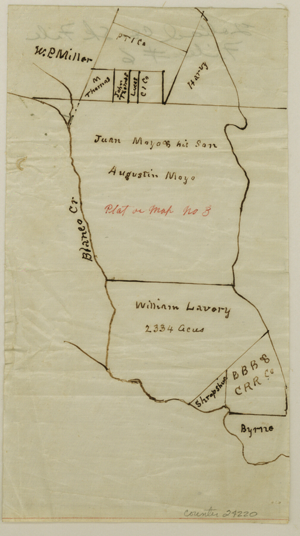
Goliad County Sketch File 6
[Sketch of Mayo tract on Blanco Creek]
-
Map/Doc
24220
-
Collection
General Map Collection
-
Object Dates
1857/12/5 (Creation Date)
1857/12/5 (File Date)
-
People and Organizations
Barnard (Surveyor/Engineer)
-
Counties
Goliad
-
Subjects
Surveying Sketch File
-
Height x Width
8.8 x 4.9 inches
22.4 x 12.4 cm
-
Medium
paper, manuscript
-
Features
Blanco Creek
Part of: General Map Collection
Edwards County Working Sketch 33

Print $40.00
- Digital $50.00
Edwards County Working Sketch 33
1947
Size 42.6 x 50.2 inches
Map/Doc 68909
McLennan County Boundary File 2

Print $38.00
- Digital $50.00
McLennan County Boundary File 2
Size 10.6 x 7.9 inches
Map/Doc 56948
Atascosa County Sketch File 39

Print $8.00
- Digital $50.00
Atascosa County Sketch File 39
1880
Size 12.2 x 8.0 inches
Map/Doc 13831
Dimmit County Working Sketch 43

Print $20.00
- Digital $50.00
Dimmit County Working Sketch 43
1978
Size 20.0 x 30.0 inches
Map/Doc 68704
Jefferson County Rolled Sketch 32

Print $40.00
- Digital $50.00
Jefferson County Rolled Sketch 32
1955
Size 26.4 x 49.3 inches
Map/Doc 9295
Brewster County Sketch File 15

Print $120.00
- Digital $50.00
Brewster County Sketch File 15
1935
Size 14.2 x 8.8 inches
Map/Doc 15758
Andrews County Rolled Sketch 18

Print $20.00
- Digital $50.00
Andrews County Rolled Sketch 18
1942
Size 26.0 x 31.3 inches
Map/Doc 8394
Crockett County Rolled Sketch 26B

Print $20.00
- Digital $50.00
Crockett County Rolled Sketch 26B
Size 33.1 x 40.1 inches
Map/Doc 8694
Trace of a copy of the map captured at the battle of Resaca de la Palma

Print $20.00
- Digital $50.00
Trace of a copy of the map captured at the battle of Resaca de la Palma
Size 18.3 x 27.3 inches
Map/Doc 73054
Terrell County Working Sketch 48

Print $40.00
- Digital $50.00
Terrell County Working Sketch 48
1958
Size 59.3 x 42.2 inches
Map/Doc 62141
Upshur County Working Sketch 14

Print $20.00
- Digital $50.00
Upshur County Working Sketch 14
1993
Size 23.1 x 37.1 inches
Map/Doc 69571
Presidio County Rolled Sketch 131A

Print $20.00
- Digital $50.00
Presidio County Rolled Sketch 131A
Size 17.5 x 14.1 inches
Map/Doc 10707
You may also like
Castro County Sketch File 14

Print $40.00
- Digital $50.00
Castro County Sketch File 14
1971
Size 13.9 x 25.1 inches
Map/Doc 11061
Jones County Rolled Sketch 4

Print $20.00
- Digital $50.00
Jones County Rolled Sketch 4
2022
Size 31.9 x 24.0 inches
Map/Doc 97150
Hood County Working Sketch 12

Print $40.00
- Digital $50.00
Hood County Working Sketch 12
1978
Size 25.2 x 55.5 inches
Map/Doc 66206
General Highway Map, Leon County, Texas

Print $20.00
General Highway Map, Leon County, Texas
1961
Size 18.3 x 24.8 inches
Map/Doc 79568
Taylor County Rolled Sketch 24

Print $20.00
- Digital $50.00
Taylor County Rolled Sketch 24
Size 19.6 x 22.7 inches
Map/Doc 7916
Ward County Rolled Sketch 18

Print $20.00
- Digital $50.00
Ward County Rolled Sketch 18
1949
Size 31.6 x 34.0 inches
Map/Doc 10109
Denton County, Texas

Print $20.00
- Digital $50.00
Denton County, Texas
1870
Size 18.6 x 22.7 inches
Map/Doc 723
General-karte der Vereinigten Staaten von Nord-Amerika nebst den grosst. Theilen von Canada & Tejas

Print $20.00
- Digital $50.00
General-karte der Vereinigten Staaten von Nord-Amerika nebst den grosst. Theilen von Canada & Tejas
Size 30.3 x 38.9 inches
Map/Doc 96790
University Lands, Block 35, Crane & Ector Counties

Print $20.00
- Digital $50.00
University Lands, Block 35, Crane & Ector Counties
1935
Size 39.9 x 45.5 inches
Map/Doc 2406
Cameron County

Print $20.00
- Digital $50.00
Cameron County
1913
Size 28.9 x 32.1 inches
Map/Doc 4752
Brazoria County Boundary File 12 1/2

Print $10.00
- Digital $50.00
Brazoria County Boundary File 12 1/2
Size 9.0 x 7.3 inches
Map/Doc 50733
Shelby County Rolled Sketch 14
Print $20.00
- Digital $50.00
Shelby County Rolled Sketch 14
Size 33.1 x 25.9 inches
Map/Doc 7782