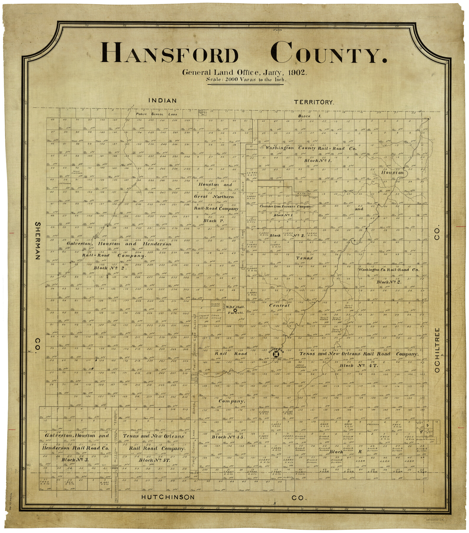
Hansford County
-
Map/Doc
4969
-
Collection
General Map Collection
-
Object Dates
1/1902 (Creation Date)
-
Counties
Hansford
-
Subjects
County
-
Height x Width
42.3 x 37.5 inches
107.4 x 95.3 cm
Part of: General Map Collection
Wise County Sketch File 7

Print $4.00
- Digital $50.00
Wise County Sketch File 7
1857
Size 8.1 x 14.0 inches
Map/Doc 40535

Brewster County Working Sketch 100

Print $40.00
- Digital $50.00
Brewster County Working Sketch 100
1979
Size 41.0 x 55.2 inches
Map/Doc 67700
Harrison County Working Sketch 1

Print $20.00
- Digital $50.00
Harrison County Working Sketch 1
1919
Size 22.6 x 25.6 inches
Map/Doc 66021
[Atlas B, Table of Contents]
![78269, [Atlas B, Table of Contents], General Map Collection](https://historictexasmaps.com/wmedia_w700/maps/78269.tif.jpg)
Print $3.00
- Digital $50.00
[Atlas B, Table of Contents]
Size 10.3 x 9.6 inches
Map/Doc 78269
DeWitt County Boundary File 25 1/2

Print $34.00
- Digital $50.00
DeWitt County Boundary File 25 1/2
Size 8.5 x 4.0 inches
Map/Doc 52522
Flight Mission No. BQR-9K, Frame 9, Brazoria County

Print $20.00
- Digital $50.00
Flight Mission No. BQR-9K, Frame 9, Brazoria County
1952
Size 18.6 x 22.3 inches
Map/Doc 84038
Hartley County Working Sketch 1

Print $20.00
- Digital $50.00
Hartley County Working Sketch 1
1893
Size 18.1 x 13.9 inches
Map/Doc 66051
Yoakum County Rolled Sketch 6

Print $20.00
- Digital $50.00
Yoakum County Rolled Sketch 6
Size 18.7 x 34.6 inches
Map/Doc 8291
Gaines County Rolled Sketch 12

Print $20.00
- Digital $50.00
Gaines County Rolled Sketch 12
1940
Size 26.6 x 33.8 inches
Map/Doc 5932
Archer County Working Sketch 23

Print $40.00
- Digital $50.00
Archer County Working Sketch 23
1981
Size 31.7 x 48.3 inches
Map/Doc 67164
Refugio County Sketch File 11

Print $6.00
- Digital $50.00
Refugio County Sketch File 11
Size 8.0 x 8.2 inches
Map/Doc 35260
You may also like
Flight Mission No. DQN-2K, Frame 156, Calhoun County

Print $20.00
- Digital $50.00
Flight Mission No. DQN-2K, Frame 156, Calhoun County
1953
Size 18.5 x 22.3 inches
Map/Doc 84318
Intracoastal Waterway in Texas - Corpus Christi to Point Isabel including Arroyo Colorado to Mo. Pac. R.R. Bridge Near Harlingen

Print $20.00
- Digital $50.00
Intracoastal Waterway in Texas - Corpus Christi to Point Isabel including Arroyo Colorado to Mo. Pac. R.R. Bridge Near Harlingen
1933
Size 27.9 x 40.8 inches
Map/Doc 61862
[Points along west and north lines of county]
![90401, [Points along west and north lines of county], Twichell Survey Records](https://historictexasmaps.com/wmedia_w700/maps/90401-1.tif.jpg)
Print $20.00
- Digital $50.00
[Points along west and north lines of county]
Size 14.7 x 19.3 inches
Map/Doc 90401
Walker County Working Sketch 18

Print $20.00
- Digital $50.00
Walker County Working Sketch 18
1991
Size 29.4 x 31.5 inches
Map/Doc 72298
Erath County Sketch File A

Print $4.00
- Digital $50.00
Erath County Sketch File A
Size 8.6 x 11.0 inches
Map/Doc 22249
Foard County Sketch File 29

Print $20.00
- Digital $50.00
Foard County Sketch File 29
Size 18.9 x 29.4 inches
Map/Doc 11494
Nacogdoches County Working Sketch 2

Print $20.00
- Digital $50.00
Nacogdoches County Working Sketch 2
1904
Size 20.5 x 24.1 inches
Map/Doc 71218
Lamar County State Real Property Sketch 1

Print $20.00
- Digital $50.00
Lamar County State Real Property Sketch 1
2013
Size 24.0 x 36.0 inches
Map/Doc 93660
Flight Mission No. BRA-7M, Frame 27, Jefferson County

Print $20.00
- Digital $50.00
Flight Mission No. BRA-7M, Frame 27, Jefferson County
1953
Size 18.5 x 22.3 inches
Map/Doc 85478
Hudspeth County Sketch File 50

Print $20.00
- Digital $50.00
Hudspeth County Sketch File 50
Size 11.2 x 8.7 inches
Map/Doc 42948
[Mrs. May Vinson Survey]
![91877, [Mrs. May Vinson Survey], Twichell Survey Records](https://historictexasmaps.com/wmedia_w700/maps/91877-1.tif.jpg)
Print $20.00
- Digital $50.00
[Mrs. May Vinson Survey]
Size 26.7 x 14.8 inches
Map/Doc 91877
Map of a part of Laguna Madre showing subdivision for mineral development

Print $40.00
- Digital $50.00
Map of a part of Laguna Madre showing subdivision for mineral development
1963
Size 68.1 x 46.0 inches
Map/Doc 2916