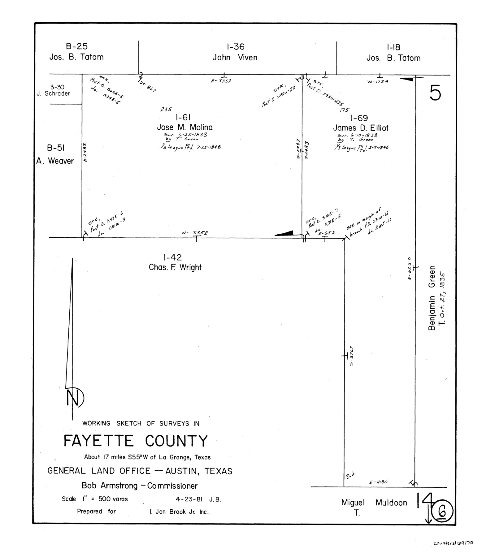
Fayette County Working Sketch 6
-
Map/Doc
69170
-
Collection
General Map Collection
-
Object Dates
4/23/1981 (Creation Date)
-
People and Organizations
Jana Brod (Draftsman)
-
Counties
Fayette
-
Subjects
Surveying Working Sketch
-
Height x Width
17.0 x 15.1 inches
43.2 x 38.4 cm
-
Scale
1" = 500 varas
Part of: General Map Collection
Garza County Rolled Sketch 6B

Print $20.00
- Digital $50.00
Garza County Rolled Sketch 6B
Size 27.6 x 36.4 inches
Map/Doc 5996
Mills County Sketch File 1

Print $8.00
- Digital $50.00
Mills County Sketch File 1
1853
Size 11.6 x 12.7 inches
Map/Doc 31641
Spanish land grants (other than porciones) in the trans-Nueces

Spanish land grants (other than porciones) in the trans-Nueces
2009
Size 11.0 x 8.5 inches
Map/Doc 94046
Comanche County Sketch File 19

Print $12.00
- Digital $50.00
Comanche County Sketch File 19
Size 13.0 x 8.0 inches
Map/Doc 19093
Flight Mission No. CGI-3N, Frame 135, Cameron County

Print $20.00
- Digital $50.00
Flight Mission No. CGI-3N, Frame 135, Cameron County
1954
Size 18.7 x 22.1 inches
Map/Doc 84608
Jefferson County Working Sketch 18

Print $20.00
- Digital $50.00
Jefferson County Working Sketch 18
1954
Size 24.2 x 30.7 inches
Map/Doc 66561
Flight Mission No. DAG-17K, Frame 139, Matagorda County

Print $20.00
- Digital $50.00
Flight Mission No. DAG-17K, Frame 139, Matagorda County
1952
Size 18.5 x 22.3 inches
Map/Doc 86356

Trinity County Sketch File 5b

Print $4.00
- Digital $50.00
Trinity County Sketch File 5b
1855
Size 12.6 x 8.0 inches
Map/Doc 38506
Duval County Sketch File 71

Print $4.00
- Digital $50.00
Duval County Sketch File 71
1953
Size 15.2 x 9.0 inches
Map/Doc 21458
Jack County Working Sketch 25

Print $20.00
- Digital $50.00
Jack County Working Sketch 25
2012
Size 32.7 x 24.9 inches
Map/Doc 93409
Montgomery County Rolled Sketch 47

Print $20.00
- Digital $50.00
Montgomery County Rolled Sketch 47
2009
Size 36.5 x 24.6 inches
Map/Doc 89032
You may also like
St. Louis, Brownsville & Mexico Railway Location Map from Mile 100 to Mile 120

Print $40.00
- Digital $50.00
St. Louis, Brownsville & Mexico Railway Location Map from Mile 100 to Mile 120
1905
Size 20.0 x 61.2 inches
Map/Doc 64167
From Aransas Pass Eastward, Texas

Print $40.00
- Digital $50.00
From Aransas Pass Eastward, Texas
1866
Size 31.4 x 53.6 inches
Map/Doc 73426
San Patricio County Sketch File 6

Print $4.00
- Digital $50.00
San Patricio County Sketch File 6
Size 8.7 x 5.5 inches
Map/Doc 36035
Plan of the City of Austin

Print $40.00
- Digital $50.00
Plan of the City of Austin
1840
Size 54.0 x 38.9 inches
Map/Doc 2176
Mileage Map - Best Roads of Texas showing principal cities, pole markings, road distances

Print $20.00
- Digital $50.00
Mileage Map - Best Roads of Texas showing principal cities, pole markings, road distances
1920
Size 12.8 x 16.2 inches
Map/Doc 95898
Terrell County Rolled Sketch 26

Print $20.00
- Digital $50.00
Terrell County Rolled Sketch 26
1914
Size 17.3 x 15.2 inches
Map/Doc 7933
Coast Chart No. 210 - Aransas Pass and Corpus Christi Bay with the coast to latitude 27° 12', Texas

Print $20.00
- Digital $50.00
Coast Chart No. 210 - Aransas Pass and Corpus Christi Bay with the coast to latitude 27° 12', Texas
1907
Size 15.4 x 23.5 inches
Map/Doc 73451
Washington County Working Sketch 2

Print $20.00
- Digital $50.00
Washington County Working Sketch 2
1981
Size 23.6 x 20.1 inches
Map/Doc 72363
Andrews County

Print $40.00
- Digital $50.00
Andrews County
1925
Size 42.3 x 55.4 inches
Map/Doc 4778
Young County Boundary File 98

Print $12.00
- Digital $50.00
Young County Boundary File 98
Size 8.8 x 7.5 inches
Map/Doc 60205
The Principal Transportation Lines extending west from Boston, New York, Philadelphia, and Baltimore

Print $20.00
- Digital $50.00
The Principal Transportation Lines extending west from Boston, New York, Philadelphia, and Baltimore
1881
Size 17.1 x 24.4 inches
Map/Doc 95908
Flight Mission No. DQO-2K, Frame 135, Galveston County

Print $20.00
- Digital $50.00
Flight Mission No. DQO-2K, Frame 135, Galveston County
1952
Size 18.7 x 22.5 inches
Map/Doc 85032