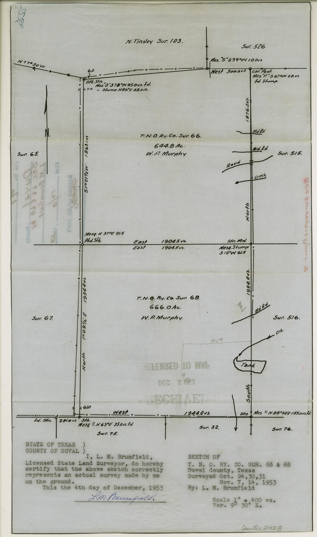
Duval County Sketch File 71
Sketch of T. N. O. Ry. Co. surveys 66 and 68
-
Map/Doc
21458
-
Collection
General Map Collection
-
Object Dates
1953/12/4 (Creation Date)
1953/12/8 (File Date)
1953/10/31 (Survey Date)
1953/11/14 (Survey Date)
-
People and Organizations
L.M. Brumfield (Surveyor/Engineer)
-
Counties
Duval
-
Subjects
Surveying Sketch File
-
Height x Width
15.2 x 9.0 inches
38.6 x 22.9 cm
-
Medium
paper, manuscript
-
Scale
1:400
-
Features
Old Road
Part of: General Map Collection
Amistad International Reservoir on Rio Grande 83

Print $20.00
- Digital $50.00
Amistad International Reservoir on Rio Grande 83
1949
Size 28.5 x 40.3 inches
Map/Doc 75512
Brazoria County Working Sketch 6

Print $20.00
- Digital $50.00
Brazoria County Working Sketch 6
1922
Size 16.8 x 24.0 inches
Map/Doc 67491
Hardin County Sketch File 21

Print $4.00
- Digital $50.00
Hardin County Sketch File 21
Size 11.2 x 8.8 inches
Map/Doc 25140
Hudspeth County Working Sketch 11

Print $20.00
- Digital $50.00
Hudspeth County Working Sketch 11
1946
Size 32.1 x 36.2 inches
Map/Doc 66292
Crane County Sketch File 26

Print $10.00
- Digital $50.00
Crane County Sketch File 26
1939
Size 11.5 x 9.0 inches
Map/Doc 19598
Webb County Rolled Sketch 7

Print $20.00
- Digital $50.00
Webb County Rolled Sketch 7
Size 29.1 x 43.7 inches
Map/Doc 8173
Wilson County Sketch File 5

Print $4.00
- Digital $50.00
Wilson County Sketch File 5
1859
Size 6.6 x 8.2 inches
Map/Doc 40408
Madison County

Print $20.00
- Digital $50.00
Madison County
1871
Size 15.2 x 20.3 inches
Map/Doc 4587
Scurry County Sketch File 1

Print $6.00
- Digital $50.00
Scurry County Sketch File 1
Size 14.5 x 9.1 inches
Map/Doc 36560
McMullen County Working Sketch 10

Print $20.00
- Digital $50.00
McMullen County Working Sketch 10
1938
Size 21.6 x 22.8 inches
Map/Doc 70711
Hutchinson County Working Sketch Graphic Index - sheet 1

Print $20.00
- Digital $50.00
Hutchinson County Working Sketch Graphic Index - sheet 1
1922
Size 44.1 x 36.8 inches
Map/Doc 76586
Young County Sketch File 13

Print $4.00
- Digital $50.00
Young County Sketch File 13
1891
Size 8.3 x 10.0 inches
Map/Doc 40878
You may also like
Bandera County Working Sketch 50

Print $20.00
- Digital $50.00
Bandera County Working Sketch 50
1985
Size 34.1 x 31.6 inches
Map/Doc 67646

Index for Texas Railroad ROW & track maps available on microfilm at THD & Archives and Records

Print $2.00
- Digital $50.00
Index for Texas Railroad ROW & track maps available on microfilm at THD & Archives and Records
1977
Size 11.3 x 8.6 inches
Map/Doc 60761
Donley County Boundary File 4

Print $10.00
- Digital $50.00
Donley County Boundary File 4
Size 5.7 x 8.4 inches
Map/Doc 52630
Crockett County Rolled Sketch 88N

Print $89.00
- Digital $50.00
Crockett County Rolled Sketch 88N
1973
Size 10.6 x 15.5 inches
Map/Doc 44132
Knox County Working Sketch 16

Print $20.00
- Digital $50.00
Knox County Working Sketch 16
1963
Size 21.9 x 22.0 inches
Map/Doc 70258
Dimmit County Sketch File 50

Print $36.00
- Digital $50.00
Dimmit County Sketch File 50
1909
Size 18.2 x 20.4 inches
Map/Doc 21181
Texas Intracoastal Waterway - Laguna Madre - Rincon de San Jose to Chubby Island

Print $20.00
- Digital $50.00
Texas Intracoastal Waterway - Laguna Madre - Rincon de San Jose to Chubby Island
1957
Size 39.2 x 27.1 inches
Map/Doc 73512
Montague County Rolled Sketch 9

Print $20.00
- Digital $50.00
Montague County Rolled Sketch 9
Size 29.1 x 39.4 inches
Map/Doc 6793
Hockley County Sketch File 2

Print $20.00
- Digital $50.00
Hockley County Sketch File 2
1900
Size 13.2 x 18.1 inches
Map/Doc 11768
Cottle County Sketch File 17

Print $6.00
- Digital $50.00
Cottle County Sketch File 17
1903
Size 7.2 x 10.9 inches
Map/Doc 19554
2008 Official Travel Map Texas

Digital $50.00
2008 Official Travel Map Texas
Size 33.4 x 36.5 inches
Map/Doc 94310