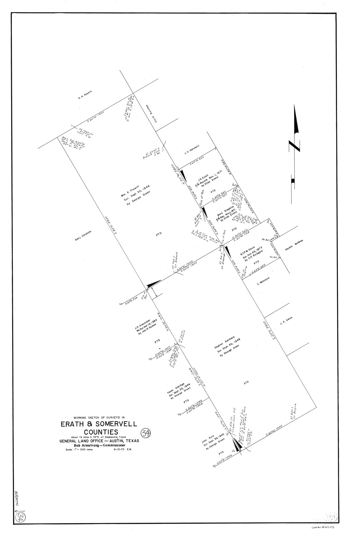
Erath County Working Sketch 34
-
Map/Doc
69115
-
Collection
General Map Collection
-
Object Dates
9/12/1972 (Creation Date)
-
People and Organizations
Elbert Menzel (Draftsman)
-
Counties
Erath Somervell
-
Subjects
Surveying Working Sketch
-
Height x Width
38.7 x 25.3 inches
98.3 x 64.3 cm
-
Scale
1" = 300 varas
Part of: General Map Collection
Cass County Rolled Sketch 7

Print $20.00
- Digital $50.00
Cass County Rolled Sketch 7
1957
Size 28.3 x 33.5 inches
Map/Doc 5413
Map of Coryell Co.

Print $40.00
- Digital $50.00
Map of Coryell Co.
1896
Size 49.8 x 43.1 inches
Map/Doc 4921
Colton's Map of the United States of America

Print $20.00
- Digital $50.00
Colton's Map of the United States of America
1866
Size 21.3 x 36.7 inches
Map/Doc 93642
Nueces County Sketch File 33

Print $20.00
- Digital $50.00
Nueces County Sketch File 33
1908
Size 22.0 x 19.2 inches
Map/Doc 42188
Jefferson County Sketch File 14

Print $60.00
- Digital $50.00
Jefferson County Sketch File 14
Size 15.8 x 13.2 inches
Map/Doc 28149
[Surveys in Austin's Colony along Saline Creek]
![180, [Surveys in Austin's Colony along Saline Creek], General Map Collection](https://historictexasmaps.com/wmedia_w700/maps/180.tif.jpg)
Print $20.00
- Digital $50.00
[Surveys in Austin's Colony along Saline Creek]
Size 20.8 x 20.7 inches
Map/Doc 180
El Paso County Working Sketch 29

Print $40.00
- Digital $50.00
El Paso County Working Sketch 29
1967
Size 43.0 x 64.8 inches
Map/Doc 69051
Maps of Gulf Intracoastal Waterway, Texas - Sabine River to the Rio Grande and connecting waterways including ship channels

Print $20.00
- Digital $50.00
Maps of Gulf Intracoastal Waterway, Texas - Sabine River to the Rio Grande and connecting waterways including ship channels
1966
Size 14.6 x 22.2 inches
Map/Doc 61975
Nueces County Working Sketch 8

Print $20.00
- Digital $50.00
Nueces County Working Sketch 8
1965
Size 20.3 x 23.8 inches
Map/Doc 71310
Map of Texas and Adjacent Regions in the Eighteenth Century

Print $20.00
- Digital $50.00
Map of Texas and Adjacent Regions in the Eighteenth Century
1915
Size 16.7 x 20.0 inches
Map/Doc 94007
Austin County Rolled Sketch 5B

Print $40.00
- Digital $50.00
Austin County Rolled Sketch 5B
Size 23.7 x 51.5 inches
Map/Doc 5107
Brazos River, Brazos River Sheet 5

Print $20.00
- Digital $50.00
Brazos River, Brazos River Sheet 5
1926
Size 27.4 x 21.7 inches
Map/Doc 69669
You may also like
Live Oak County Working Sketch 3

Print $20.00
- Digital $50.00
Live Oak County Working Sketch 3
1910
Size 21.5 x 19.0 inches
Map/Doc 70588
Red River County Working Sketch 35

Print $20.00
- Digital $50.00
Red River County Working Sketch 35
1964
Size 34.9 x 41.0 inches
Map/Doc 72018
Shelby County Sketch File 3

Print $4.00
- Digital $50.00
Shelby County Sketch File 3
1849
Size 11.9 x 7.9 inches
Map/Doc 36595
Sherman County

Print $20.00
- Digital $50.00
Sherman County
1918
Size 13.6 x 15.3 inches
Map/Doc 92919
Pecos County Sketch File 53

Print $20.00
- Digital $50.00
Pecos County Sketch File 53
Size 18.0 x 38.9 inches
Map/Doc 10569
Crockett County Sketch File 82

Print $8.00
- Digital $50.00
Crockett County Sketch File 82
1940
Size 11.3 x 8.7 inches
Map/Doc 19895
Flight Mission No. DQN-6K, Frame 92, Calhoun County

Print $20.00
- Digital $50.00
Flight Mission No. DQN-6K, Frame 92, Calhoun County
1953
Size 18.6 x 22.3 inches
Map/Doc 84452
Culberson County Working Sketch 40a

Print $20.00
- Digital $50.00
Culberson County Working Sketch 40a
1981
Size 37.3 x 38.6 inches
Map/Doc 68494
[Beaumont, Sour Lake and Western Ry. Right of Way and Alignment - Frisco]
![64120, [Beaumont, Sour Lake and Western Ry. Right of Way and Alignment - Frisco], General Map Collection](https://historictexasmaps.com/wmedia_w700/maps/64120.tif.jpg)
Print $20.00
- Digital $50.00
[Beaumont, Sour Lake and Western Ry. Right of Way and Alignment - Frisco]
1910
Size 19.7 x 45.6 inches
Map/Doc 64120
Rains County Rolled Sketch 2

Print $41.00
- Digital $50.00
Rains County Rolled Sketch 2
1958
Size 10.4 x 15.4 inches
Map/Doc 48829
Harris County Sketch File 35

Print $4.00
- Digital $50.00
Harris County Sketch File 35
1840
Size 14.1 x 9.0 inches
Map/Doc 25438
Flight Mission No. BRA-16M, Frame 49, Jefferson County

Print $20.00
- Digital $50.00
Flight Mission No. BRA-16M, Frame 49, Jefferson County
1953
Size 18.4 x 22.5 inches
Map/Doc 85666