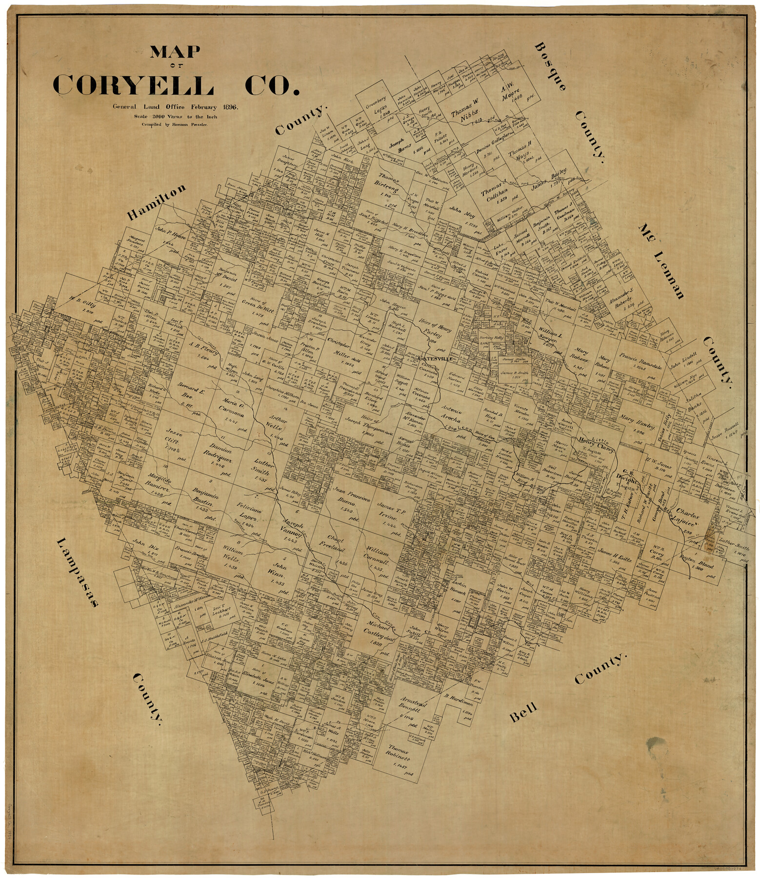
Map of Coryell Co.
-
Map/Doc
4921
-
Collection
General Map Collection
-
Object Dates
1896 (Creation Date)
-
People and Organizations
Texas General Land Office (Publisher)
Herman Pressler (Compiler)
-
Counties
Coryell
-
Subjects
County
-
Height x Width
49.8 x 43.1 inches
126.5 x 109.5 cm
Part of: General Map Collection
San Augustine County Working Sketch 11a

Print $20.00
- Digital $50.00
San Augustine County Working Sketch 11a
Size 18.8 x 24.4 inches
Map/Doc 63698
Flight Mission No. BRA-7M, Frame 122, Jefferson County

Print $20.00
- Digital $50.00
Flight Mission No. BRA-7M, Frame 122, Jefferson County
1953
Size 18.7 x 22.3 inches
Map/Doc 85516

Dimmit County Rolled Sketch 3

Print $20.00
- Digital $50.00
Dimmit County Rolled Sketch 3
Size 31.9 x 36.2 inches
Map/Doc 76142
Zavala County

Print $40.00
- Digital $50.00
Zavala County
1915
Size 39.6 x 48.3 inches
Map/Doc 63147
Morris County Rolled Sketch 2A

Print $20.00
- Digital $50.00
Morris County Rolled Sketch 2A
Size 24.3 x 19.1 inches
Map/Doc 10241
Flight Mission No. CGI-4N, Frame 164, Cameron County

Print $20.00
- Digital $50.00
Flight Mission No. CGI-4N, Frame 164, Cameron County
1955
Size 18.6 x 22.3 inches
Map/Doc 84672
Flight Mission No. BRE-4P, Frame 166, Nueces County

Print $20.00
- Digital $50.00
Flight Mission No. BRE-4P, Frame 166, Nueces County
1956
Size 18.5 x 22.4 inches
Map/Doc 86829
Wichita County Sketch File 35

Print $8.00
- Digital $50.00
Wichita County Sketch File 35
1950
Size 14.3 x 8.5 inches
Map/Doc 40157
Goliad County Sketch File 30

Print $40.00
- Digital $50.00
Goliad County Sketch File 30
Size 13.0 x 15.0 inches
Map/Doc 24327
Carson County Boundary File 5c

Print $10.00
- Digital $50.00
Carson County Boundary File 5c
Size 14.2 x 8.7 inches
Map/Doc 51146
Jefferson County NRC Article 33.136 Sketch 5

Print $4.00
- Digital $50.00
Jefferson County NRC Article 33.136 Sketch 5
2005
Size 14.1 x 8.8 inches
Map/Doc 83170
You may also like
Finder Map of Greater San Antonio

Print $20.00
- Digital $50.00
Finder Map of Greater San Antonio
1950
Size 28.7 x 21.4 inches
Map/Doc 94029
Kimble County Boundary File 2

Print $26.00
- Digital $50.00
Kimble County Boundary File 2
Size 9.6 x 6.2 inches
Map/Doc 64833
Williamson County Sketch File 8a

Print $4.00
- Digital $50.00
Williamson County Sketch File 8a
1849
Size 10.4 x 8.3 inches
Map/Doc 40320
[Map of Counties south of Panhandle]
![92960, [Map of Counties south of Panhandle], Twichell Survey Records](https://historictexasmaps.com/wmedia_w700/maps/92960-1.tif.jpg)
Print $20.00
- Digital $50.00
[Map of Counties south of Panhandle]
Size 22.1 x 15.8 inches
Map/Doc 92960
Gaines County

Print $40.00
- Digital $50.00
Gaines County
1902
Size 49.7 x 38.6 inches
Map/Doc 89863
Flight Mission No. DQN-2K, Frame 80, Calhoun County

Print $20.00
- Digital $50.00
Flight Mission No. DQN-2K, Frame 80, Calhoun County
1953
Size 18.4 x 22.2 inches
Map/Doc 84272
Hutchinson County Rolled Sketch 44-10

Print $20.00
- Digital $50.00
Hutchinson County Rolled Sketch 44-10
2002
Size 24.0 x 36.0 inches
Map/Doc 77546
[Galveston, Harrisburg & San Antonio Railroad from Cuero to Stockdale]
![64192, [Galveston, Harrisburg & San Antonio Railroad from Cuero to Stockdale], General Map Collection](https://historictexasmaps.com/wmedia_w700/maps/64192.tif.jpg)
Print $20.00
- Digital $50.00
[Galveston, Harrisburg & San Antonio Railroad from Cuero to Stockdale]
1907
Size 14.1 x 34.1 inches
Map/Doc 64192
Part of Garza, Crosby, Lynn, and Lubbock Counties

Print $20.00
- Digital $50.00
Part of Garza, Crosby, Lynn, and Lubbock Counties
1912
Size 24.7 x 20.4 inches
Map/Doc 91324
Red River County Working Sketch 52

Print $20.00
- Digital $50.00
Red River County Working Sketch 52
1971
Size 35.5 x 24.7 inches
Map/Doc 72035
Origins of Exports and Destination of Imports at Houston during 1921

Print $20.00
- Digital $50.00
Origins of Exports and Destination of Imports at Houston during 1921
1921
Size 13.6 x 19.6 inches
Map/Doc 97170
Cameron County NRC Article 33.136 Location Key Sheet

Print $20.00
- Digital $50.00
Cameron County NRC Article 33.136 Location Key Sheet
1983
Size 27.0 x 23.0 inches
Map/Doc 89294