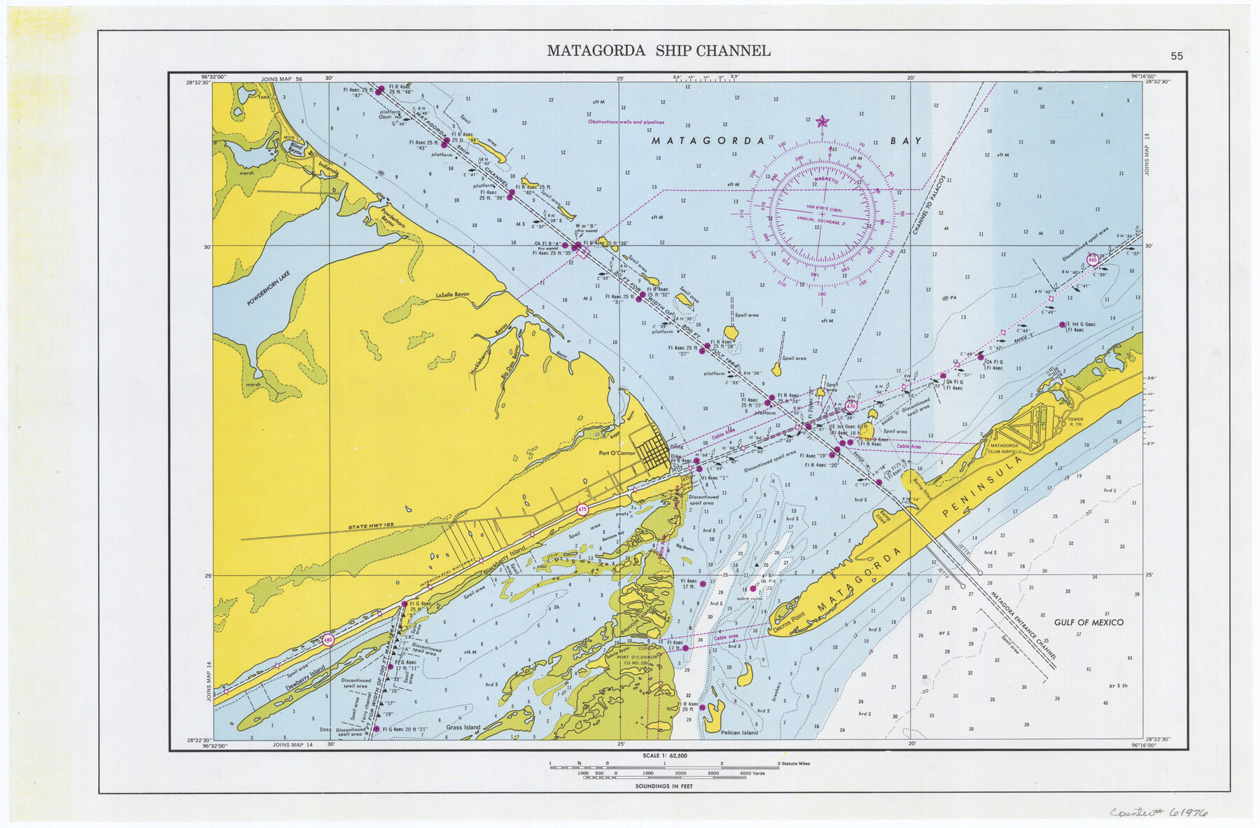
Maps of Gulf Intracoastal Waterway, Texas - Sabine River to the Rio Grande and connecting waterways including ship channels
-
Map/Doc
61976
-
Collection
General Map Collection
-
Object Dates
1966 (Creation Date)
-
Subjects
Intracoastal Waterways
-
Height x Width
14.6 x 22.2 inches
37.1 x 56.4 cm
Part of: General Map Collection
Upton County Rolled Sketch 41

Print $20.00
- Digital $50.00
Upton County Rolled Sketch 41
Size 27.4 x 40.8 inches
Map/Doc 8080
Fort Bend County Rolled Sketch C

Print $20.00
- Digital $50.00
Fort Bend County Rolled Sketch C
Size 12.7 x 16.6 inches
Map/Doc 5905
Map of the Property traversed by the Trinity & Sabine Railroad from Fortieth Mile to Ogden, Texas

Print $40.00
- Digital $50.00
Map of the Property traversed by the Trinity & Sabine Railroad from Fortieth Mile to Ogden, Texas
1882
Size 39.5 x 93.2 inches
Map/Doc 64046
Map of the Trinity Artesian Reservoirs of the Black and Grand Prairies of Texas including the Eastern and Western Cross Timbers

Print $20.00
- Digital $50.00
Map of the Trinity Artesian Reservoirs of the Black and Grand Prairies of Texas including the Eastern and Western Cross Timbers
1900
Size 32.7 x 31.9 inches
Map/Doc 75920
Polk County Sketch File 11

Print $4.00
- Digital $50.00
Polk County Sketch File 11
Size 9.2 x 8.1 inches
Map/Doc 34142
Township 5 South Range 13 West, South Western District, Louisiana

Print $20.00
- Digital $50.00
Township 5 South Range 13 West, South Western District, Louisiana
1879
Size 19.3 x 24.8 inches
Map/Doc 65885
Denton County Working Sketch 9

Print $20.00
- Digital $50.00
Denton County Working Sketch 9
1959
Size 33.7 x 37.6 inches
Map/Doc 68614
Marion County Working Sketch 45

Print $20.00
- Digital $50.00
Marion County Working Sketch 45
2005
Size 27.0 x 29.2 inches
Map/Doc 83576
Webb County Rolled Sketch 50

Print $20.00
- Digital $50.00
Webb County Rolled Sketch 50
1943
Size 38.2 x 42.6 inches
Map/Doc 10125
[Sketch for Mineral Application 1112 - Colorado River, H. E. Chambers]
![65640, [Sketch for Mineral Application 1112 - Colorado River, H. E. Chambers], General Map Collection](https://historictexasmaps.com/wmedia_w700/maps/65640.tif.jpg)
Print $20.00
- Digital $50.00
[Sketch for Mineral Application 1112 - Colorado River, H. E. Chambers]
1918
Size 17.2 x 28.3 inches
Map/Doc 65640
Crockett County Rolled Sketch 27

Print $20.00
- Digital $50.00
Crockett County Rolled Sketch 27
1925
Size 20.8 x 38.0 inches
Map/Doc 5586
Flight Mission No. CRC-2R, Frame 54, Chambers County

Print $20.00
- Digital $50.00
Flight Mission No. CRC-2R, Frame 54, Chambers County
1956
Size 18.5 x 22.3 inches
Map/Doc 84727
You may also like
Henderson County Working Sketch 7

Print $20.00
- Digital $50.00
Henderson County Working Sketch 7
1922
Size 12.5 x 18.8 inches
Map/Doc 66140
Potter County Boundary File 6b

Print $20.00
- Digital $50.00
Potter County Boundary File 6b
Size 37.9 x 8.7 inches
Map/Doc 58040
Flight Mission No. BRA-16M, Frame 86, Jefferson County

Print $20.00
- Digital $50.00
Flight Mission No. BRA-16M, Frame 86, Jefferson County
1953
Size 18.5 x 22.3 inches
Map/Doc 85698
Flight Mission No. BRA-7M, Frame 120, Jefferson County

Print $20.00
- Digital $50.00
Flight Mission No. BRA-7M, Frame 120, Jefferson County
1953
Size 18.7 x 22.4 inches
Map/Doc 85514
Real County Working Sketch 19

Print $3.00
- Digital $50.00
Real County Working Sketch 19
1944
Size 12.0 x 10.4 inches
Map/Doc 71911
Mississippi River to Galveston

Print $40.00
- Digital $50.00
Mississippi River to Galveston
1961
Size 37.1 x 49.6 inches
Map/Doc 69944
Limestone County Sketch File 4

Print $20.00
- Digital $50.00
Limestone County Sketch File 4
1847
Size 15.2 x 34.1 inches
Map/Doc 12001
General Highway Map, Johnson County, Texas

Print $20.00
General Highway Map, Johnson County, Texas
1940
Size 18.3 x 24.8 inches
Map/Doc 79149
Roberts County Working Sketch 8

Print $20.00
- Digital $50.00
Roberts County Working Sketch 8
1963
Size 21.9 x 26.0 inches
Map/Doc 63534
Central America II. Including Texas, California and the Northern States of Mexico

Print $20.00
- Digital $50.00
Central America II. Including Texas, California and the Northern States of Mexico
1842
Size 14.1 x 16.7 inches
Map/Doc 93927
[Strickland Survey Sketch Showing Abercrombie Corner, Exhibit C]
![91369, [Strickland Survey Sketch Showing Abercrombie Corner, Exhibit C], Twichell Survey Records](https://historictexasmaps.com/wmedia_w700/maps/91369-1.tif.jpg)
Print $20.00
- Digital $50.00
[Strickland Survey Sketch Showing Abercrombie Corner, Exhibit C]
Size 18.0 x 24.5 inches
Map/Doc 91369
Culberson County Rolled Sketch 52

Print $20.00
- Digital $50.00
Culberson County Rolled Sketch 52
1966
Size 19.1 x 24.9 inches
Map/Doc 5671