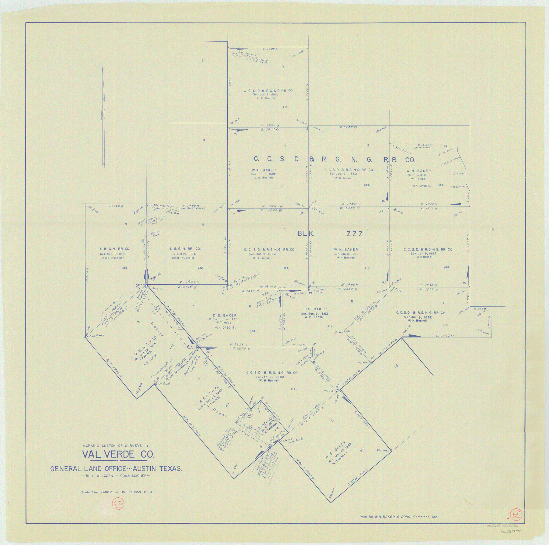
Val Verde County Working Sketch 60
-
Map/Doc
72195
-
Collection
General Map Collection
-
Object Dates
12/29/1958 (Creation Date)
-
People and Organizations
Otto G. Kurio (Draftsman)
-
Counties
Val Verde
-
Subjects
Surveying Working Sketch
-
Height x Width
32.1 x 32.4 inches
81.5 x 82.3 cm
-
Scale
1" = 400 varas
Part of: General Map Collection
Flight Mission No. DAG-23K, Frame 144, Matagorda County

Print $20.00
- Digital $50.00
Flight Mission No. DAG-23K, Frame 144, Matagorda County
1953
Size 17.4 x 22.6 inches
Map/Doc 86492
Panola County Working Sketch 24

Print $20.00
- Digital $50.00
Panola County Working Sketch 24
1957
Map/Doc 71433
Shelby County Sketch File 18

Print $4.00
- Digital $50.00
Shelby County Sketch File 18
1875
Size 7.2 x 6.1 inches
Map/Doc 36636
The Woodlands, a real hometown for people and companies

The Woodlands, a real hometown for people and companies
Size 39.0 x 26.1 inches
Map/Doc 94287
Kaufman County

Print $40.00
- Digital $50.00
Kaufman County
1942
Size 50.0 x 41.0 inches
Map/Doc 95552
Kinney County Working Sketch 42

Print $20.00
- Digital $50.00
Kinney County Working Sketch 42
1973
Size 20.4 x 33.7 inches
Map/Doc 70224
Galveston County Sketch File 2a

Print $4.00
- Digital $50.00
Galveston County Sketch File 2a
1848
Size 14.3 x 8.8 inches
Map/Doc 23350
Brazoria County Rolled Sketch 48
Print $20.00
- Digital $50.00
Brazoria County Rolled Sketch 48
1952
Size 28.6 x 41.3 inches
Map/Doc 5181
Brewster County Working Sketch 53

Print $20.00
- Digital $50.00
Brewster County Working Sketch 53
1951
Size 32.1 x 16.5 inches
Map/Doc 67587

Matagorda County Sketch File 42b

Print $12.00
- Digital $50.00
Matagorda County Sketch File 42b
1913
Size 11.2 x 8.7 inches
Map/Doc 30862
Leon County Working Sketch 26

Print $20.00
- Digital $50.00
Leon County Working Sketch 26
1969
Size 43.1 x 46.9 inches
Map/Doc 70425
You may also like
Pecos County Rolled Sketch 110

Print $20.00
- Digital $50.00
Pecos County Rolled Sketch 110
Size 29.1 x 30.4 inches
Map/Doc 7255
Flight Mission No. CGI-4N, Frame 163, Cameron County

Print $20.00
- Digital $50.00
Flight Mission No. CGI-4N, Frame 163, Cameron County
1955
Size 18.6 x 22.3 inches
Map/Doc 84671
Copy of sketch in Nacogdoches Donation 724 on file in GLO

Print $20.00
- Digital $50.00
Copy of sketch in Nacogdoches Donation 724 on file in GLO
1890
Size 18.0 x 10.9 inches
Map/Doc 75803
Irion County Rolled Sketch 24

Print $40.00
- Digital $50.00
Irion County Rolled Sketch 24
Size 49.4 x 37.4 inches
Map/Doc 9257
McMullen County Working Sketch 10

Print $20.00
- Digital $50.00
McMullen County Working Sketch 10
1938
Size 21.6 x 22.8 inches
Map/Doc 70711
Crockett County Rolled Sketch 50

Print $20.00
- Digital $50.00
Crockett County Rolled Sketch 50
1940
Size 31.5 x 40.7 inches
Map/Doc 8714

West Part of Edwards County

Print $40.00
- Digital $50.00
West Part of Edwards County
1975
Size 59.9 x 39.7 inches
Map/Doc 95489
Zavala County Sketch File 11b

Print $4.00
- Digital $50.00
Zavala County Sketch File 11b
1886
Size 10.2 x 8.3 inches
Map/Doc 41277
Kerr County Working Sketch 24

Print $20.00
- Digital $50.00
Kerr County Working Sketch 24
1966
Size 35.9 x 38.3 inches
Map/Doc 70055

Map of Brewster Co.

Print $40.00
- Digital $50.00
Map of Brewster Co.
1896
Size 58.4 x 17.3 inches
Map/Doc 4892