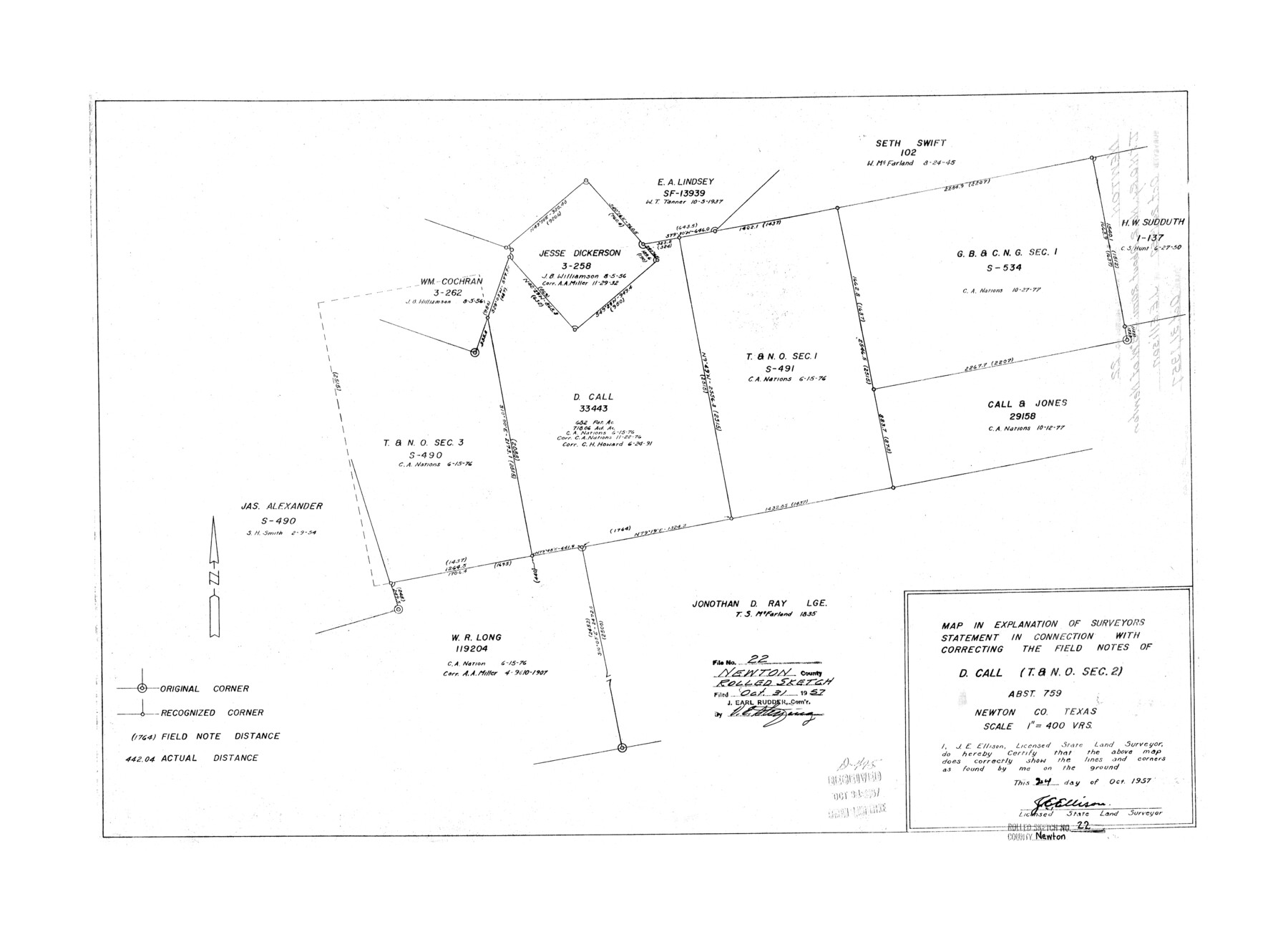
Newton County Rolled Sketch 22
Map in explanation of surveyors statement in connection with correcting the field notes of D. Call (T. & N. O. sec. 2) abst. 759
-
Map/Doc
6849
-
Collection
General Map Collection
-
Object Dates
1957/10/24 (Creation Date)
1957/10/31 (File Date)
-
People and Organizations
J.E. Ellison (Surveyor/Engineer)
-
Counties
Newton
-
Subjects
Surveying Rolled Sketch
-
Height x Width
20.8 x 28.7 inches
52.8 x 72.9 cm
-
Scale
1" = 400 varas
Part of: General Map Collection
United States - Gulf Coast - Padre I. and Laguna Madre Lat. 27° 12' to Lat. 26° 33' Texas

Print $20.00
- Digital $50.00
United States - Gulf Coast - Padre I. and Laguna Madre Lat. 27° 12' to Lat. 26° 33' Texas
1913
Size 26.8 x 18.4 inches
Map/Doc 72817
Travis County Working Sketch 32

Print $20.00
- Digital $50.00
Travis County Working Sketch 32
1965
Size 28.0 x 40.0 inches
Map/Doc 69416
San Jacinto County Working Sketch 25

Print $20.00
- Digital $50.00
San Jacinto County Working Sketch 25
1943
Size 34.4 x 34.2 inches
Map/Doc 63738
Martin County Working Sketch 6

Print $20.00
- Digital $50.00
Martin County Working Sketch 6
1971
Size 41.8 x 36.9 inches
Map/Doc 70824
Harris County Working Sketch 6

Print $20.00
- Digital $50.00
Harris County Working Sketch 6
1905
Size 20.4 x 12.1 inches
Map/Doc 65898
Shackelford County Sketch File 12

Print $26.00
- Digital $50.00
Shackelford County Sketch File 12
1949
Size 14.4 x 8.8 inches
Map/Doc 36580
Wise County Sketch File 11

Print $4.00
- Digital $50.00
Wise County Sketch File 11
1860
Size 12.8 x 8.0 inches
Map/Doc 40544
Nueces County NRC Article 33.136 Location Key Sheet

Print $20.00
- Digital $50.00
Nueces County NRC Article 33.136 Location Key Sheet
1975
Size 27.3 x 23.0 inches
Map/Doc 88587
Tyler County Working Sketch Graphic Index

Print $20.00
- Digital $50.00
Tyler County Working Sketch Graphic Index
1944
Size 47.4 x 39.6 inches
Map/Doc 76719
Gulf of Mexico

Print $20.00
- Digital $50.00
Gulf of Mexico
1908
Size 18.3 x 26.9 inches
Map/Doc 72655
Karnes County Working Sketch 6

Print $20.00
- Digital $50.00
Karnes County Working Sketch 6
1961
Size 23.3 x 27.5 inches
Map/Doc 66654
Gaines County Sketch File 14

Print $20.00
- Digital $50.00
Gaines County Sketch File 14
1954
Size 23.4 x 32.1 inches
Map/Doc 11525
You may also like
Hockley County Working Sketch 4

Print $40.00
- Digital $50.00
Hockley County Working Sketch 4
1973
Size 38.7 x 52.3 inches
Map/Doc 66194
Hunt County Boundary File 2

Print $6.00
- Digital $50.00
Hunt County Boundary File 2
Size 13.0 x 8.1 inches
Map/Doc 55189
Current Miscellaneous File 42

Print $4.00
- Digital $50.00
Current Miscellaneous File 42
Size 11.2 x 8.7 inches
Map/Doc 73981
Anderson County Sketch File 18

Print $40.00
- Digital $50.00
Anderson County Sketch File 18
1880
Size 16.0 x 13.5 inches
Map/Doc 10801
Presidio County Sketch File 118

Print $16.00
- Digital $50.00
Presidio County Sketch File 118
Size 14.3 x 8.9 inches
Map/Doc 34919
Conoco Official Road Map New Mexico

Print $20.00
- Digital $50.00
Conoco Official Road Map New Mexico
1934
Size 18.5 x 24.4 inches
Map/Doc 92436
Sutton County Working Sketch 49

Print $20.00
- Digital $50.00
Sutton County Working Sketch 49
1955
Size 43.3 x 19.5 inches
Map/Doc 62392
[Worksheets related to the Wilson Strickland survey and vicinity]
![91381, [Worksheets related to the Wilson Strickland survey and vicinity], Twichell Survey Records](https://historictexasmaps.com/wmedia_w700/maps/91381-1.tif.jpg)
Print $20.00
- Digital $50.00
[Worksheets related to the Wilson Strickland survey and vicinity]
Size 20.1 x 24.8 inches
Map/Doc 91381
[Atlas E, Table of Contents]
![78357, [Atlas E, Table of Contents], General Map Collection](https://historictexasmaps.com/wmedia_w700/maps/78357.tif.jpg)
Print $3.00
- Digital $50.00
[Atlas E, Table of Contents]
Size 17.8 x 11.0 inches
Map/Doc 78357
Newton County Working Sketch 4

Print $20.00
- Digital $50.00
Newton County Working Sketch 4
1924
Size 24.1 x 21.0 inches
Map/Doc 71250
Foard County Sketch File 6

Print $4.00
- Digital $50.00
Foard County Sketch File 6
1875
Size 10.2 x 8.4 inches
Map/Doc 22808
Young Territory

Print $20.00
- Digital $50.00
Young Territory
1873
Size 45.3 x 42.8 inches
Map/Doc 1988