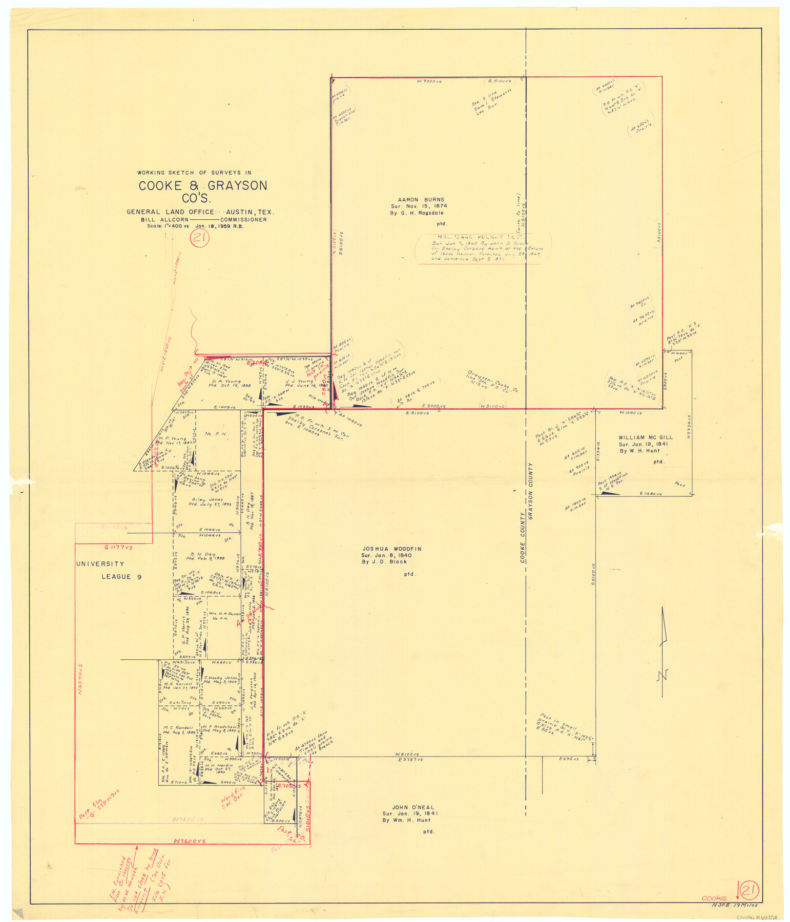
Cooke County Working Sketch 21
-
Map/Doc
68258
-
Collection
General Map Collection
-
Object Dates
1/18/1959 (Creation Date)
-
People and Organizations
Roy Buckholts (Draftsman)
-
Counties
Cooke Grayson
-
Subjects
Surveying Working Sketch
-
Height x Width
35.3 x 30.3 inches
89.7 x 77.0 cm
-
Scale
1" = 400 varas
Part of: General Map Collection
Zavala County Working Sketch 28

Print $20.00
- Digital $50.00
Zavala County Working Sketch 28
1994
Size 34.0 x 43.5 inches
Map/Doc 62103
Kaufman County Sketch File 10

Print $4.00
- Digital $50.00
Kaufman County Sketch File 10
1873
Size 10.2 x 8.2 inches
Map/Doc 28643
Flight Mission No. DQO-12K, Frame 43, Galveston County

Print $20.00
- Digital $50.00
Flight Mission No. DQO-12K, Frame 43, Galveston County
1952
Size 18.6 x 22.4 inches
Map/Doc 85233

Hemphill County Rolled Sketch 2

Print $20.00
- Digital $50.00
Hemphill County Rolled Sketch 2
Size 26.4 x 29.8 inches
Map/Doc 6185

Blanco County Working Sketch 5

Print $20.00
- Digital $50.00
Blanco County Working Sketch 5
1941
Size 38.3 x 28.4 inches
Map/Doc 67364
Real County Working Sketch 61

Print $20.00
- Digital $50.00
Real County Working Sketch 61
1964
Size 37.9 x 44.5 inches
Map/Doc 71953

Duval County Sketch File B

Print $20.00
- Digital $50.00
Duval County Sketch File B
1880
Size 15.5 x 20.6 inches
Map/Doc 11412
Tabular exhibit of the land occupied by the roadbed of the Galveston, Harrisburg and San Antonio Railway in El Paso County, Texas

Print $20.00
- Digital $50.00
Tabular exhibit of the land occupied by the roadbed of the Galveston, Harrisburg and San Antonio Railway in El Paso County, Texas
Size 12.7 x 8.2 inches
Map/Doc 64499
Henderson County Rolled Sketch 11

Print $20.00
- Digital $50.00
Henderson County Rolled Sketch 11
1915
Size 29.2 x 41.6 inches
Map/Doc 76147
You may also like
Flight Mission No. DQN-2K, Frame 41, Calhoun County

Print $20.00
- Digital $50.00
Flight Mission No. DQN-2K, Frame 41, Calhoun County
1953
Size 18.5 x 22.2 inches
Map/Doc 84246
Sabine Bank to East Bay including Heald Bank

Print $20.00
- Digital $50.00
Sabine Bank to East Bay including Heald Bank
1946
Size 44.8 x 33.9 inches
Map/Doc 69845
Map of Jasper and Newton Counties

Print $20.00
- Digital $50.00
Map of Jasper and Newton Counties
1862
Size 36.5 x 25.8 inches
Map/Doc 3714
Hutchinson County Working Sketch 45

Print $20.00
- Digital $50.00
Hutchinson County Working Sketch 45
1979
Size 20.3 x 17.5 inches
Map/Doc 66405
City of Corpus Christi, Texas

Print $20.00
- Digital $50.00
City of Corpus Christi, Texas
1969
Size 22.6 x 51.0 inches
Map/Doc 96520
[Plat showing traverse line run from I. R. Rock at southeast corner survey 58 northerly to the I. R. Rock corner at the northeast 60]
![91597, [Plat showing traverse line run from I. R. Rock at southeast corner survey 58 northerly to the I. R. Rock corner at the northeast 60], Twichell Survey Records](https://historictexasmaps.com/wmedia_w700/maps/91597-1.tif.jpg)
Print $20.00
- Digital $50.00
[Plat showing traverse line run from I. R. Rock at southeast corner survey 58 northerly to the I. R. Rock corner at the northeast 60]
1935
Size 22.5 x 18.1 inches
Map/Doc 91597
McMullen County Working Sketch 14

Print $20.00
- Digital $50.00
McMullen County Working Sketch 14
1938
Size 28.6 x 37.1 inches
Map/Doc 70715
Kendall County Rolled Sketch 4

Print $20.00
- Digital $50.00
Kendall County Rolled Sketch 4
1945
Size 29.9 x 27.0 inches
Map/Doc 6457

Brown County Sketch File 25

Print $6.00
- Digital $50.00
Brown County Sketch File 25
1890
Size 11.2 x 15.4 inches
Map/Doc 16623
No. 2 Chart of Corpus Christi Pass, Texas

Print $20.00
- Digital $50.00
No. 2 Chart of Corpus Christi Pass, Texas
1878
Size 18.3 x 27.3 inches
Map/Doc 73014
Map showing the fortification at Point Isabel

Print $20.00
- Digital $50.00
Map showing the fortification at Point Isabel
1864
Size 18.3 x 27.9 inches
Map/Doc 72921