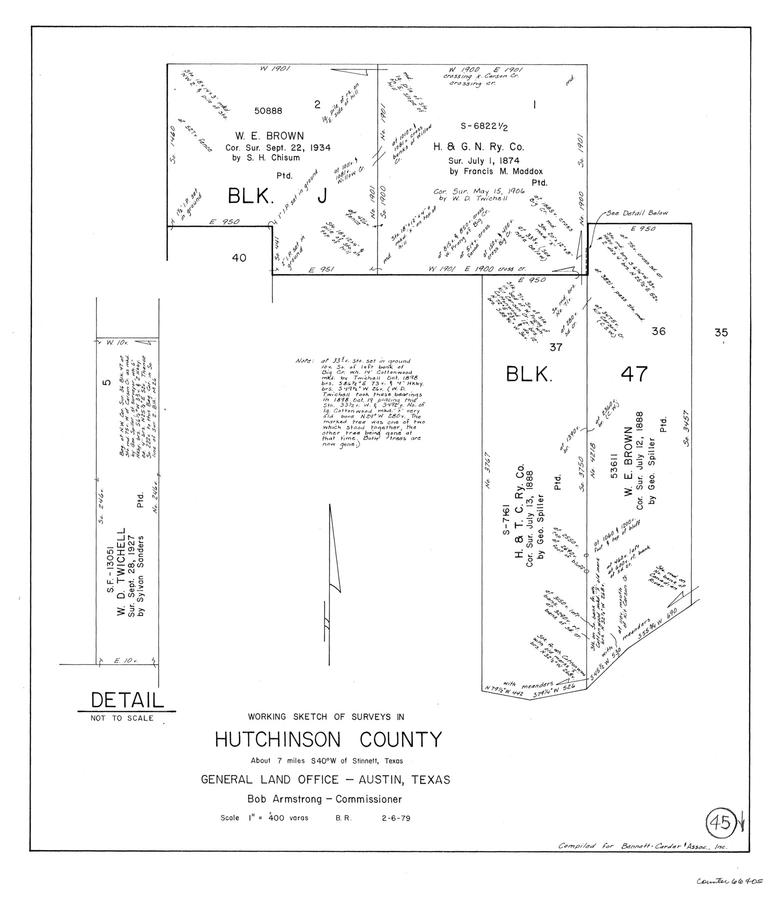
Hutchinson County Working Sketch 45
-
Map/Doc
66405
-
Collection
General Map Collection
-
Object Dates
2/6/1979 (Creation Date)
-
People and Organizations
Beverly Robison (Draftsman)
-
Counties
Hutchinson
-
Subjects
Surveying Working Sketch
-
Height x Width
20.3 x 17.5 inches
51.6 x 44.5 cm
-
Scale
1" = 400 varas
Part of: General Map Collection
Floyd County Sketch File 29

Print $20.00
- Digital $50.00
Floyd County Sketch File 29
Size 17.0 x 16.5 inches
Map/Doc 11488
Presidio County Working Sketch 139

Print $20.00
- Digital $50.00
Presidio County Working Sketch 139
1990
Size 34.7 x 38.2 inches
Map/Doc 71817
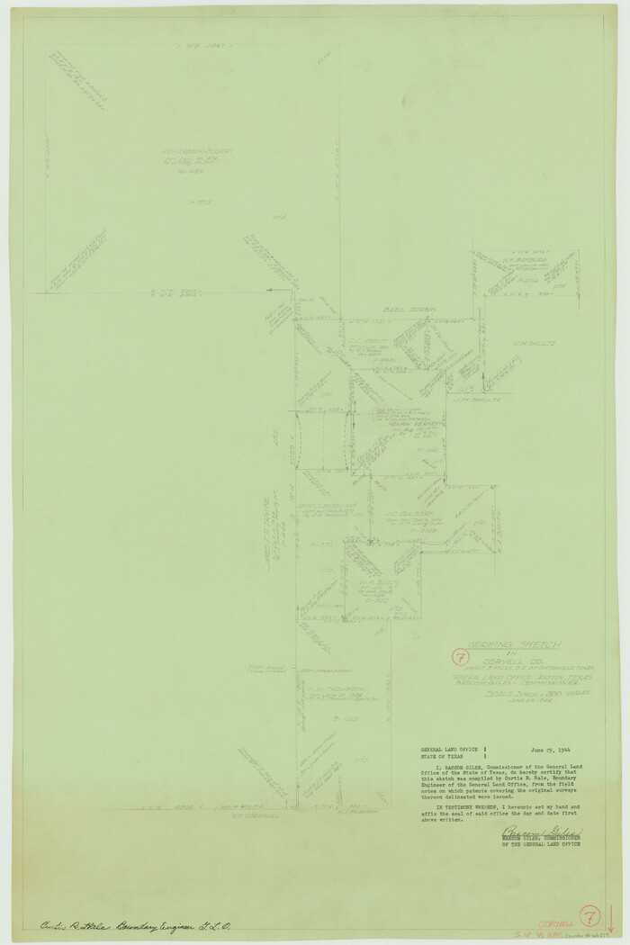
Coryell County Working Sketch 7
Print $20.00
- Digital $50.00
Coryell County Working Sketch 7
1944
Size 31.6 x 21.1 inches
Map/Doc 68214
Floyd County Working Sketch 10

Print $20.00
- Digital $50.00
Floyd County Working Sketch 10
1916
Size 15.4 x 27.3 inches
Map/Doc 69189
County and Railroad Map of Texas

Print $20.00
- Digital $50.00
County and Railroad Map of Texas
1876
Size 17.0 x 16.0 inches
Map/Doc 93624
Texas, Intracoastal Waterway, Ayres Bay to Aransas Bay

Print $40.00
- Digital $50.00
Texas, Intracoastal Waterway, Ayres Bay to Aransas Bay
1934
Size 33.2 x 48.5 inches
Map/Doc 69997

San Jacinto County Working Sketch 30

Print $20.00
- Digital $50.00
San Jacinto County Working Sketch 30
Size 18.2 x 24.4 inches
Map/Doc 63743
Presidio County Sketch File 67

Print $6.00
- Digital $50.00
Presidio County Sketch File 67
1940
Size 11.3 x 8.9 inches
Map/Doc 34659
Travis County Rolled Sketch 32A

Print $40.00
- Digital $50.00
Travis County Rolled Sketch 32A
Size 57.6 x 37.3 inches
Map/Doc 10013
Hale County Sketch File 11

Print $8.00
- Digital $50.00
Hale County Sketch File 11
1899
Size 11.1 x 8.5 inches
Map/Doc 24739
Cameron County Rolled Sketch 26

Print $20.00
- Digital $50.00
Cameron County Rolled Sketch 26
Size 18.5 x 24.3 inches
Map/Doc 5390
You may also like
Flight Mission No. DAG-21K, Frame 41, Matagorda County

Print $20.00
- Digital $50.00
Flight Mission No. DAG-21K, Frame 41, Matagorda County
1952
Size 18.6 x 19.3 inches
Map/Doc 86408
Kimble County Working Sketch 69

Print $20.00
- Digital $50.00
Kimble County Working Sketch 69
1965
Size 42.4 x 30.5 inches
Map/Doc 70137
Terrell County Working Sketch 46

Print $20.00
- Digital $50.00
Terrell County Working Sketch 46
1958
Size 23.8 x 23.4 inches
Map/Doc 62139
Brewster County Rolled Sketch B

Print $40.00
- Digital $50.00
Brewster County Rolled Sketch B
1882
Size 67.4 x 37.7 inches
Map/Doc 8465
Greater Fort Worth New City Map

Print $20.00
Greater Fort Worth New City Map
1925
Size 33.5 x 22.6 inches
Map/Doc 76286
Map Showing Showing San Antonio & Aransas Pass Railway from San Antonio to Wilson County Line

Print $40.00
- Digital $50.00
Map Showing Showing San Antonio & Aransas Pass Railway from San Antonio to Wilson County Line
Size 25.8 x 101.6 inches
Map/Doc 64283
Calcasieu Pass to Sabine Pass

Print $20.00
- Digital $50.00
Calcasieu Pass to Sabine Pass
1972
Size 44.9 x 35.8 inches
Map/Doc 69811
Texas Intracoastal Waterway - Laguna Madre - Rincon de San Jose to Chubby Island

Print $20.00
- Digital $50.00
Texas Intracoastal Waterway - Laguna Madre - Rincon de San Jose to Chubby Island
1957
Size 39.2 x 27.1 inches
Map/Doc 73512
El Paso County Rolled Sketch 38
Print $40.00
- Digital $50.00
El Paso County Rolled Sketch 38
1922
Size 14.1 x 61.3 inches
Map/Doc 8866
Duval County Sketch File 17

Print $20.00
- Digital $50.00
Duval County Sketch File 17
1876
Size 19.0 x 17.8 inches
Map/Doc 11383
San Saba County Sketch File 8

Print $6.00
- Digital $50.00
San Saba County Sketch File 8
Size 6.6 x 7.9 inches
Map/Doc 36430
Map of Grimes Co.

Print $20.00
- Digital $50.00
Map of Grimes Co.
1881
Size 32.6 x 17.5 inches
Map/Doc 66843