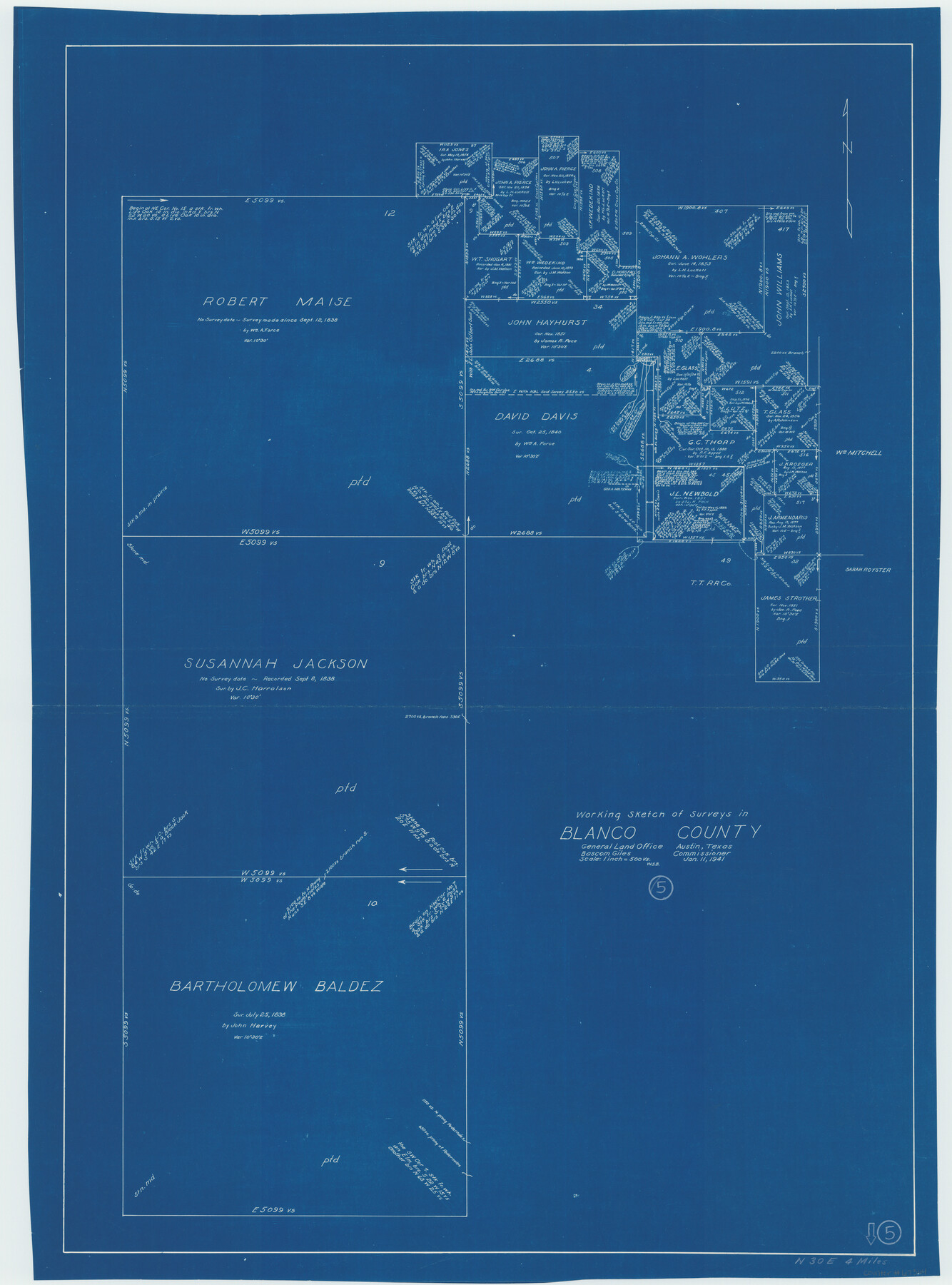
Blanco County Working Sketch 5
-
Map/Doc
67364
-
Collection
General Map Collection
-
Object Dates
1/11/1941 (Creation Date)
-
People and Organizations
Bascom Giles (GLO Commissioner)
W. S. Brewington (Draftsman)
-
Counties
Blanco
-
Subjects
Surveying Working Sketch
-
Height x Width
38.3 x 28.4 inches
97.3 x 72.1 cm
-
Scale
1" = 500 varas
-
Comments
Surveys located about four miles North 30 degrees East of Johnson City, Texas.
Part of: General Map Collection
Comal County State Real Property Sketch 1

Print $134.00
- Digital $50.00
Comal County State Real Property Sketch 1
2006
Size 23.8 x 35.4 inches
Map/Doc 88635
Intracoastal Waterway - Laguna Madre - Chubby Island to Stover Point including the Arroyo Colorado, Texas

Print $20.00
- Digital $50.00
Intracoastal Waterway - Laguna Madre - Chubby Island to Stover Point including the Arroyo Colorado, Texas
1976
Size 15.6 x 43.8 inches
Map/Doc 75900
Tom Green County Working Sketch 12

Print $20.00
- Digital $50.00
Tom Green County Working Sketch 12
1975
Size 30.0 x 41.1 inches
Map/Doc 69381
Presidio County Rolled Sketch A-2

Print $20.00
- Digital $50.00
Presidio County Rolled Sketch A-2
1889
Size 36.9 x 43.9 inches
Map/Doc 9770
Gaines County Working Sketch 36

Print $20.00
- Digital $50.00
Gaines County Working Sketch 36
Size 23.5 x 36.7 inches
Map/Doc 69336
Burleson County Working Sketch 4

Print $20.00
- Digital $50.00
Burleson County Working Sketch 4
1979
Size 33.3 x 35.6 inches
Map/Doc 67723
Duval County Boundary File 3a

Print $8.00
- Digital $50.00
Duval County Boundary File 3a
Size 12.7 x 8.0 inches
Map/Doc 52726
Live Oak County Working Sketch 20

Print $20.00
- Digital $50.00
Live Oak County Working Sketch 20
1962
Size 29.7 x 35.7 inches
Map/Doc 70605

Loving County Rolled Sketch 2A

Print $40.00
- Digital $50.00
Loving County Rolled Sketch 2A
1952
Size 41.8 x 71.0 inches
Map/Doc 9463
Crockett County Sketch File 77

Print $8.00
- Digital $50.00
Crockett County Sketch File 77
1932
Size 11.2 x 8.7 inches
Map/Doc 19877
Presidio County Working Sketch Graphic Index, West Part, Sheet 2 (Sketches 75 to Most Recent)

Print $20.00
- Digital $50.00
Presidio County Working Sketch Graphic Index, West Part, Sheet 2 (Sketches 75 to Most Recent)
1974
Size 40.7 x 31.9 inches
Map/Doc 76673
You may also like
C. B. Livestock Co.'s West-Ranch, Bailey County, Texas

Print $2.00
- Digital $50.00
C. B. Livestock Co.'s West-Ranch, Bailey County, Texas
Size 8.8 x 11.6 inches
Map/Doc 90383
Flight Mission No. DAG-21K, Frame 97, Matagorda County

Print $20.00
- Digital $50.00
Flight Mission No. DAG-21K, Frame 97, Matagorda County
1952
Size 18.4 x 22.2 inches
Map/Doc 86426
Randall County Sketch File 3

Print $20.00
- Digital $50.00
Randall County Sketch File 3
1930
Size 23.8 x 16.3 inches
Map/Doc 12206
Comanche County Sketch File 18

Print $4.00
- Digital $50.00
Comanche County Sketch File 18
Size 8.4 x 7.8 inches
Map/Doc 19091
Flight Mission No. DQN-2K, Frame 38, Calhoun County

Print $20.00
- Digital $50.00
Flight Mission No. DQN-2K, Frame 38, Calhoun County
1953
Size 15.5 x 15.4 inches
Map/Doc 84243
Flight Mission No. BRE-2P, Frame 109, Nueces County

Print $20.00
- Digital $50.00
Flight Mission No. BRE-2P, Frame 109, Nueces County
1956
Size 18.6 x 22.5 inches
Map/Doc 86794
Cameron County Rolled Sketch 26

Print $20.00
- Digital $50.00
Cameron County Rolled Sketch 26
1960
Size 18.0 x 24.4 inches
Map/Doc 5391
[McK. & Williams No. 601 and surrounding surveys, Travis County]
![10782, [McK. & Williams No. 601 and surrounding surveys, Travis County], Maddox Collection](https://historictexasmaps.com/wmedia_w700/maps/10782.tif.jpg)
Print $20.00
- Digital $50.00
[McK. & Williams No. 601 and surrounding surveys, Travis County]
Size 18.3 x 12.3 inches
Map/Doc 10782
Live Oak County Rolled Sketch 10A

Print $20.00
- Digital $50.00
Live Oak County Rolled Sketch 10A
1983
Size 38.4 x 43.6 inches
Map/Doc 9457
Flight Mission No. DCL-7C, Frame 118, Kenedy County

Print $20.00
- Digital $50.00
Flight Mission No. DCL-7C, Frame 118, Kenedy County
1943
Size 18.4 x 22.3 inches
Map/Doc 86083
Flight Mission No. DIX-10P, Frame 76, Aransas County

Print $20.00
- Digital $50.00
Flight Mission No. DIX-10P, Frame 76, Aransas County
1956
Size 18.8 x 22.4 inches
Map/Doc 83937
Rio Grande, Raymondville Sheet

Print $20.00
- Digital $50.00
Rio Grande, Raymondville Sheet
1925
Size 43.7 x 17.8 inches
Map/Doc 65127