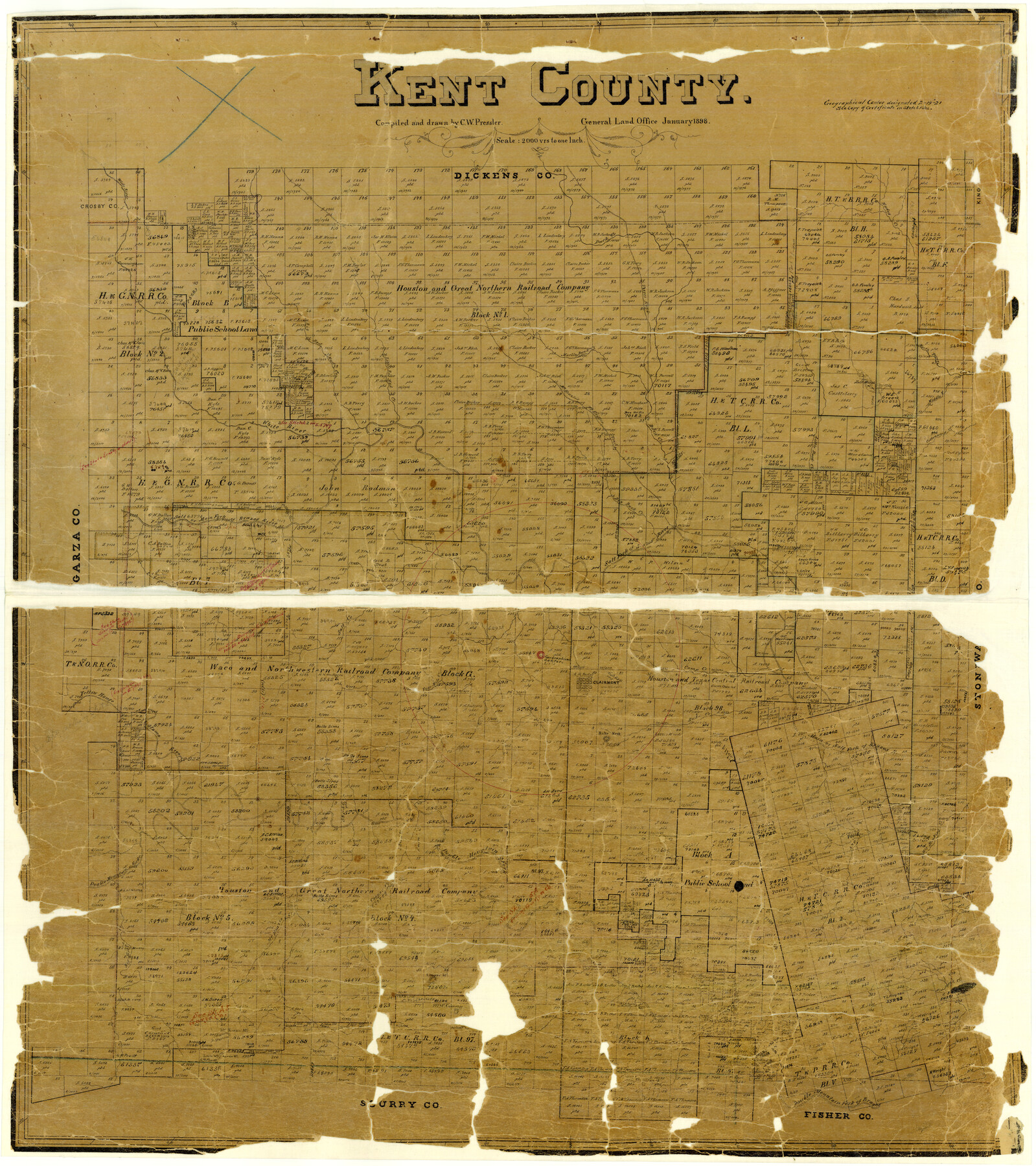
Kent County
-
Map/Doc
3755
-
Collection
General Map Collection
-
Object Dates
1898 (Creation Date)
-
People and Organizations
Texas General Land Office (Publisher)
Chas. W. Pressler (Draftsman)
Chas. W. Pressler (Compiler)
-
Counties
Kent
-
Subjects
County
-
Height x Width
39.5 x 35.0 inches
100.3 x 88.9 cm
-
Features
Little Stinking Creek
Yellow House River
Alamo River
Four Mile Creek
Clairmont
Buke Knob
Buke Creek
Cooper Creek
McKenzie Creek
Salt Creek
Nicholson's Creek
Cooper Mountain
Big Grape Creek
McKenzie Mountain
Little McKenzie Mountain
Converse Mountain
Double Mountain Fork of Brazos River
White River
Cottonwood Creek
Little Duck Creek
Dry Duck Creek
Callis Creek
Main Fork of Brazos River
Salt Fork of Brazos River
McKenzie's Fort Griffin Trail
Middle F[ork of] Croton River
North Prong of Croton River
Marble Bank Creek
Little Red Mud Creek
Big Red Mud Creek
Duck Creek
Teepee Road
Hades Creek
Part of: General Map Collection
Flight Mission No. CGI-4N, Frame 183, Cameron County

Print $20.00
- Digital $50.00
Flight Mission No. CGI-4N, Frame 183, Cameron County
1955
Size 18.6 x 22.3 inches
Map/Doc 84686
Intracoastal Waterway, Houma, LA to Corpus Christi, TX

Print $5.00
- Digital $50.00
Intracoastal Waterway, Houma, LA to Corpus Christi, TX
Size 22.2 x 29.6 inches
Map/Doc 61913
Township 1 South Range 12 West, South Western District, Louisiana

Print $20.00
- Digital $50.00
Township 1 South Range 12 West, South Western District, Louisiana
1884
Size 19.5 x 24.7 inches
Map/Doc 65880
Jim Wells County Rolled Sketch 1

Print $20.00
- Digital $50.00
Jim Wells County Rolled Sketch 1
1981
Size 43.2 x 32.4 inches
Map/Doc 9324
[Surveys in Austin's Colony along the Navidad River; John P. Borden for Thos. H. Borden]
![77, [Surveys in Austin's Colony along the Navidad River; John P. Borden for Thos. H. Borden], General Map Collection](https://historictexasmaps.com/wmedia_w700/maps/77.tif.jpg)
Print $20.00
- Digital $50.00
[Surveys in Austin's Colony along the Navidad River; John P. Borden for Thos. H. Borden]
1831
Size 20.6 x 9.3 inches
Map/Doc 77
Duval County Sketch File 45b

Print $40.00
- Digital $50.00
Duval County Sketch File 45b
1936
Size 26.0 x 18.1 inches
Map/Doc 11399
Wilson County

Print $40.00
- Digital $50.00
Wilson County
1921
Size 39.9 x 48.8 inches
Map/Doc 95677
Live Oak County Sketch File 10

Print $6.00
- Digital $50.00
Live Oak County Sketch File 10
1876
Size 10.0 x 15.5 inches
Map/Doc 30263
Outer Continental Shelf Leasing Maps (Louisiana Offshore Operations)

Print $20.00
- Digital $50.00
Outer Continental Shelf Leasing Maps (Louisiana Offshore Operations)
1955
Size 8.8 x 10.0 inches
Map/Doc 76091
Harris County Working Sketch 4

Print $20.00
- Digital $50.00
Harris County Working Sketch 4
Size 20.7 x 26.6 inches
Map/Doc 65896
Comanche County Working Sketch 6

Print $20.00
- Digital $50.00
Comanche County Working Sketch 6
1935
Size 26.4 x 17.8 inches
Map/Doc 68140
San Jacinto County Working Sketch 4

Print $20.00
- Digital $50.00
San Jacinto County Working Sketch 4
1934
Size 16.2 x 20.8 inches
Map/Doc 63717
You may also like
[Plat of Boundary Line between Comal and Hays Counties]
![65328, [Plat of Boundary Line between Comal and Hays Counties], General Map Collection](https://historictexasmaps.com/wmedia_w700/pdf_converted_jpg/qi_pdf_thumbnail_19768.jpg)
Print $20.00
- Digital $50.00
[Plat of Boundary Line between Comal and Hays Counties]
1947
Size 11.4 x 17.7 inches
Map/Doc 65328
Sketch from the map of Bailey Co.

Print $2.00
- Digital $50.00
Sketch from the map of Bailey Co.
Size 8.4 x 7.6 inches
Map/Doc 464
United States, 1956 Revised Edition

Print $40.00
- Digital $50.00
United States, 1956 Revised Edition
1946
Size 48.0 x 36.3 inches
Map/Doc 78631
Kerr County Sketch File 15

Print $20.00
- Digital $50.00
Kerr County Sketch File 15
Size 23.7 x 16.8 inches
Map/Doc 11919
Hunt County Boundary File 10a

Print $40.00
- Digital $50.00
Hunt County Boundary File 10a
Size 42.1 x 10.5 inches
Map/Doc 55262
The Republic County of Shelby. January 28, 1839

Print $20.00
The Republic County of Shelby. January 28, 1839
2020
Size 21.1 x 21.7 inches
Map/Doc 96281
Harris County NRC Article 33.136 Location Key Sheet

Print $20.00
- Digital $50.00
Harris County NRC Article 33.136 Location Key Sheet
1982
Size 27.0 x 22.5 inches
Map/Doc 77026
Working Sketch in Hockley, Lamb, and Lubbock Counties

Print $20.00
- Digital $50.00
Working Sketch in Hockley, Lamb, and Lubbock Counties
1911
Size 16.7 x 26.6 inches
Map/Doc 92213
Taylor County Working Sketch 2

Print $20.00
- Digital $50.00
Taylor County Working Sketch 2
1930
Size 27.3 x 23.1 inches
Map/Doc 69611
El Paso County Sketch File 28

Print $18.00
- Digital $50.00
El Paso County Sketch File 28
1939
Size 15.2 x 9.5 inches
Map/Doc 22070
Nora Jane Wilson Lease

Print $20.00
- Digital $50.00
Nora Jane Wilson Lease
1952
Size 12.5 x 15.0 inches
Map/Doc 92962
Jasper County Sketch File 5

Print $4.00
- Digital $50.00
Jasper County Sketch File 5
Size 8.4 x 12.1 inches
Map/Doc 27770