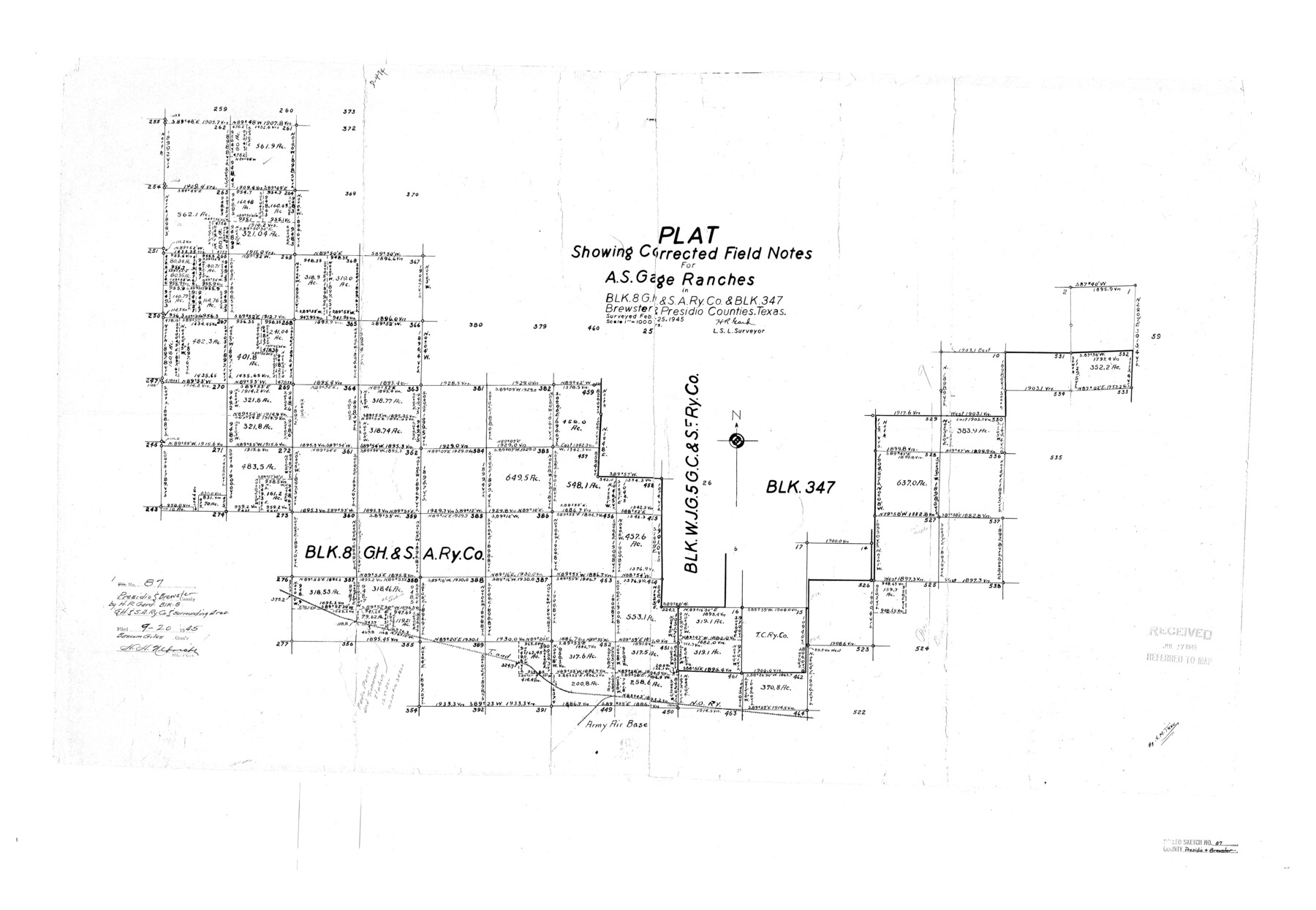
Presidio County Rolled Sketch 87
Plat showing corrected field notes for A.S. Gage Ranches in Blk. 8, G. H. & S. A. Ry. Co. & Blk. 347, Brewster & Presidio Counties, Texas
-
Map/Doc
7373
-
Collection
General Map Collection
-
Object Dates
1945/2/25 (Survey Date)
1945/9/20 (File Date)
-
People and Organizations
H.R. Gard (Surveyor/Engineer)
-
Counties
Presidio Brewster
-
Subjects
Surveying Rolled Sketch
-
Height x Width
26.4 x 38.2 inches
67.1 x 97.0 cm
-
Scale
1" = 1000 varas
Part of: General Map Collection
Kinney County Rolled Sketch 11

Print $20.00
- Digital $50.00
Kinney County Rolled Sketch 11
1944
Size 39.2 x 32.0 inches
Map/Doc 6540
Right of Way and Track Map of The Wichita Falls & Southern Railroad Company

Print $40.00
- Digital $50.00
Right of Way and Track Map of The Wichita Falls & Southern Railroad Company
1942
Size 25.0 x 56.2 inches
Map/Doc 64520
Gregg County Working Sketch 4

Print $20.00
- Digital $50.00
Gregg County Working Sketch 4
1931
Size 29.1 x 32.9 inches
Map/Doc 63270
Hutchinson County Working Sketch 49

Print $20.00
- Digital $50.00
Hutchinson County Working Sketch 49
1988
Size 35.2 x 37.3 inches
Map/Doc 66409
Aransas Pass to Baffin Bay

Print $20.00
- Digital $50.00
Aransas Pass to Baffin Bay
1966
Size 42.3 x 35.0 inches
Map/Doc 73415
Navarro County Sketch File 11

Print $4.00
- Digital $50.00
Navarro County Sketch File 11
1859
Size 10.4 x 8.2 inches
Map/Doc 32320
Cameron County

Print $20.00
- Digital $50.00
Cameron County
1976
Size 31.0 x 38.3 inches
Map/Doc 95447
Crockett County Working Sketch 16

Print $20.00
- Digital $50.00
Crockett County Working Sketch 16
1917
Size 24.0 x 29.0 inches
Map/Doc 68349
Orange County Working Sketch 42

Print $20.00
- Digital $50.00
Orange County Working Sketch 42
1979
Size 19.6 x 25.4 inches
Map/Doc 71374
Colorado County Sketch File 16

Print $4.00
- Digital $50.00
Colorado County Sketch File 16
Size 8.2 x 10.3 inches
Map/Doc 18945
Uvalde County Working Sketch 29

Print $20.00
- Digital $50.00
Uvalde County Working Sketch 29
1958
Size 25.3 x 41.0 inches
Map/Doc 72099
Armstrong County Sketch File B

Print $26.00
- Digital $50.00
Armstrong County Sketch File B
1903
Size 14.2 x 8.5 inches
Map/Doc 13669
You may also like
Johnson County Sketch File 15

Print $2.00
- Digital $50.00
Johnson County Sketch File 15
1881
Size 8.1 x 7.3 inches
Map/Doc 28455
Hardin County Sketch File 33

Print $20.00
- Digital $50.00
Hardin County Sketch File 33
Size 25.4 x 35.4 inches
Map/Doc 11632
Webb County Sketch File 4-1

Print $6.00
- Digital $50.00
Webb County Sketch File 4-1
1874
Size 10.3 x 8.2 inches
Map/Doc 39722
Travis County Sketch File 66

Print $12.00
- Digital $50.00
Travis County Sketch File 66
1950
Size 14.2 x 9.0 inches
Map/Doc 38440
Harris County Sketch File AA-1

Print $20.00
- Digital $50.00
Harris County Sketch File AA-1
Size 19.0 x 26.1 inches
Map/Doc 11646
Tom Green County Rolled Sketch 24

Print $20.00
- Digital $50.00
Tom Green County Rolled Sketch 24
Size 14.4 x 19.1 inches
Map/Doc 8006
Brown County Sketch File 25

Print $6.00
- Digital $50.00
Brown County Sketch File 25
1890
Size 11.2 x 15.4 inches
Map/Doc 16623
Travis County Sketch File 69A

Print $20.00
- Digital $50.00
Travis County Sketch File 69A
Size 18.0 x 20.9 inches
Map/Doc 12476
[H. & T. C. Block 47, H. & G. N. Block E]
![91259, [H. & T. C. Block 47, H. & G. N. Block E], Twichell Survey Records](https://historictexasmaps.com/wmedia_w700/maps/91259-1.tif.jpg)
Print $20.00
- Digital $50.00
[H. & T. C. Block 47, H. & G. N. Block E]
1874
Size 22.1 x 12.9 inches
Map/Doc 91259
Hardin County Sketch File 5a

Print $6.00
- Digital $50.00
Hardin County Sketch File 5a
Size 8.1 x 3.5 inches
Map/Doc 25094
San Patricio County Rolled Sketch 45

Print $20.00
- Digital $50.00
San Patricio County Rolled Sketch 45
1979
Size 24.0 x 33.5 inches
Map/Doc 7729
Flight Mission No. DQN-1K, Frame 145, Calhoun County

Print $20.00
- Digital $50.00
Flight Mission No. DQN-1K, Frame 145, Calhoun County
1953
Size 18.6 x 22.3 inches
Map/Doc 84208