Galveston County NRC Article 33.136 Sketch 40
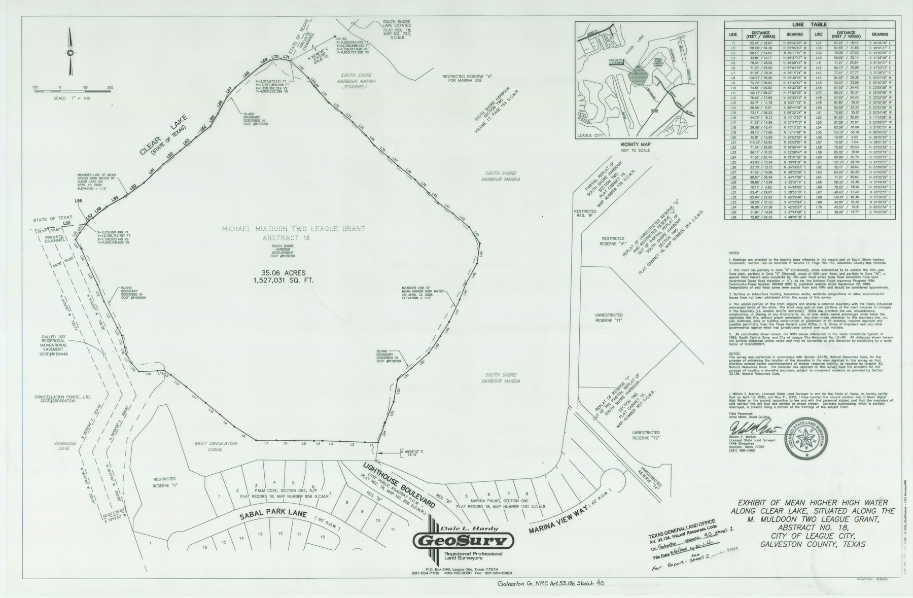
Exhibit of Mean Higher High Water Along Clear Lake, Situated Along M. Muldoon Two League Grant, Abstract 18, South Shore Harbor, League City
-
Map/Doc
83061
-
Collection
General Map Collection
-
Object Dates
2005/5/11 (Creation Date)
2006/9/6 (File Date)
-
People and Organizations
GeoSurv (Publisher)
GeoSurv (Printer)
William E. Merten (Surveyor/Engineer)
-
Counties
Galveston
-
Subjects
Surveying CBS
-
Height x Width
23.9 x 36.5 inches
60.7 x 92.7 cm
-
Medium
multi-page, multi-format
-
Comments
Survey located about 24 miles North 44 degrees West of Galveston, Texas.
Part of: General Map Collection
Reeves County Working Sketch 8

Print $20.00
- Digital $50.00
Reeves County Working Sketch 8
1948
Size 22.1 x 31.0 inches
Map/Doc 63451
Uvalde County Sketch File 19

Print $4.00
- Digital $50.00
Uvalde County Sketch File 19
1882
Size 10.6 x 8.6 inches
Map/Doc 39000
Presidio County Rolled Sketch 53

Print $20.00
- Digital $50.00
Presidio County Rolled Sketch 53
1911
Size 13.0 x 22.2 inches
Map/Doc 7346
Dimmit County Sketch File 24

Print $4.00
- Digital $50.00
Dimmit County Sketch File 24
1885
Size 13.0 x 8.7 inches
Map/Doc 21140
Briscoe County

Print $20.00
- Digital $50.00
Briscoe County
1930
Size 42.3 x 35.8 inches
Map/Doc 95439
Val Verde County Sketch File XXX7

Print $6.00
- Digital $50.00
Val Verde County Sketch File XXX7
Size 11.0 x 15.4 inches
Map/Doc 39104
Howard County Sketch File 9

Print $20.00
- Digital $50.00
Howard County Sketch File 9
Size 19.4 x 15.9 inches
Map/Doc 11797
Duval County Sketch File 45b

Print $40.00
- Digital $50.00
Duval County Sketch File 45b
1936
Size 26.0 x 18.1 inches
Map/Doc 11399
Edwards County Working Sketch 75

Print $20.00
- Digital $50.00
Edwards County Working Sketch 75
1959
Size 20.0 x 25.8 inches
Map/Doc 68951
Jefferson County NRC Article 33.136 Sketch 8

Print $20.00
- Digital $50.00
Jefferson County NRC Article 33.136 Sketch 8
2007
Size 20.1 x 18.7 inches
Map/Doc 87503
Coke County Rolled Sketch 24

Print $20.00
- Digital $50.00
Coke County Rolled Sketch 24
Size 35.8 x 33.8 inches
Map/Doc 8633
1875 land survey for the International and Great Northern Rail-road Company

Print $40.00
- Digital $50.00
1875 land survey for the International and Great Northern Rail-road Company
1875
Size 42.5 x 60.6 inches
Map/Doc 2306
You may also like

Current Miscellaneous File 16

Print $20.00
- Digital $50.00
Current Miscellaneous File 16
1951
Size 10.7 x 8.2 inches
Map/Doc 73830
Fractional Township No. 1N and Township No. 2N R. No. 2E, Deaf Smith and Parmer Counties comprising Capitol Leagues 439 and 452 and parts of Capitol Leagues 431, 432, 433, 438, 440, 451, 453, 458, 459, and 460

Print $20.00
- Digital $50.00
Fractional Township No. 1N and Township No. 2N R. No. 2E, Deaf Smith and Parmer Counties comprising Capitol Leagues 439 and 452 and parts of Capitol Leagues 431, 432, 433, 438, 440, 451, 453, 458, 459, and 460
1906
Size 27.1 x 22.4 inches
Map/Doc 93966
Presidio County Sketch File 86

Print $4.00
- Digital $50.00
Presidio County Sketch File 86
1950
Size 16.1 x 21.8 inches
Map/Doc 11724
Cottle County Sketch File 14

Print $50.00
- Digital $50.00
Cottle County Sketch File 14
1918
Size 11.3 x 8.8 inches
Map/Doc 19491
Parker County Sketch File 39

Print $4.00
- Digital $50.00
Parker County Sketch File 39
Size 8.0 x 12.7 inches
Map/Doc 33583
Morris County Rolled Sketch 2A

Print $20.00
- Digital $50.00
Morris County Rolled Sketch 2A
Size 24.2 x 19.0 inches
Map/Doc 10253
[Surveying Sketch of Buckman, et al in Unknown County]
![498, [Surveying Sketch of Buckman, et al in Unknown County], Maddox Collection](https://historictexasmaps.com/wmedia_w700/maps/498.tif.jpg)
Print $3.00
- Digital $50.00
[Surveying Sketch of Buckman, et al in Unknown County]
Size 11.7 x 11.9 inches
Map/Doc 498
Mitchell County Boundary File 1c

Print $12.00
- Digital $50.00
Mitchell County Boundary File 1c
Size 8.7 x 12.3 inches
Map/Doc 57361
Eastland County Working Sketch 10

Print $20.00
- Digital $50.00
Eastland County Working Sketch 10
1919
Size 20.2 x 16.3 inches
Map/Doc 68791
General Highway Map Burnet County, Texas

Print $20.00
- Digital $50.00
General Highway Map Burnet County, Texas
1953
Size 25.8 x 18.7 inches
Map/Doc 92470
[Surveys along the Cibolo, Balcones and Leon Creeks]
![69728, [Surveys along the Cibolo, Balcones and Leon Creeks], General Map Collection](https://historictexasmaps.com/wmedia_w700/maps/69728-1.tif.jpg)
Print $20.00
- Digital $50.00
[Surveys along the Cibolo, Balcones and Leon Creeks]
1841
Size 14.5 x 21.0 inches
Map/Doc 69728