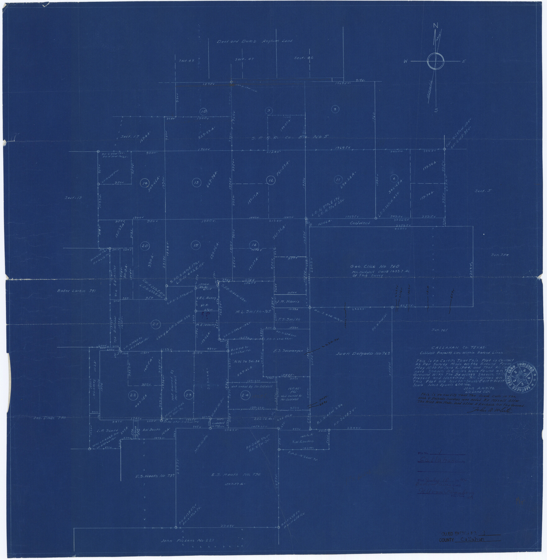
Callahan County Rolled Sketch 1
[S. P. R.R. Co. Block 5 and adjoining surveys south and east]
-
Map/Doc
5379
-
Collection
General Map Collection
-
Object Dates
1944/6/6 (Creation Date)
1944/7/18 (File Date)
-
People and Organizations
John A. White (Surveyor/Engineer)
-
Counties
Callahan
-
Subjects
Surveying Rolled Sketch
-
Height x Width
26.9 x 26.3 inches
68.3 x 66.8 cm
-
Medium
blueprint/diazo
-
Scale
1" = 600 varas
-
Comments
See Callahan County Sketch File 15 (35890) for surveyor’s report.
Related maps
Callahan County Sketch File 15

Print $16.00
- Digital $50.00
Callahan County Sketch File 15
1944
Size 11.2 x 8.8 inches
Map/Doc 35890
Part of: General Map Collection
McLennan County Sketch File 43

Print $4.00
- Digital $50.00
McLennan County Sketch File 43
1873
Size 10.0 x 8.1 inches
Map/Doc 31333
Duval County Sketch File 47

Print $6.00
- Digital $50.00
Duval County Sketch File 47
Size 11.5 x 8.8 inches
Map/Doc 21402
Jackson County Sketch File 29

Print $10.00
- Digital $50.00
Jackson County Sketch File 29
Size 13.4 x 8.7 inches
Map/Doc 27725
Upshur County Working Sketch 9

Print $20.00
- Digital $50.00
Upshur County Working Sketch 9
1963
Size 27.9 x 17.7 inches
Map/Doc 69565
Flight Mission No. DAG-4C, Frame 150, Matagorda County

Print $20.00
- Digital $50.00
Flight Mission No. DAG-4C, Frame 150, Matagorda County
1943
Size 18.5 x 18.4 inches
Map/Doc 86441
[Portion of Harrison County]
![78366, [Portion of Harrison County], General Map Collection](https://historictexasmaps.com/wmedia_w700/maps/78366.tif.jpg)
Print $3.00
- Digital $50.00
[Portion of Harrison County]
1841
Size 15.7 x 11.6 inches
Map/Doc 78366
Flight Mission No. BRA-7M, Frame 196, Jefferson County

Print $20.00
- Digital $50.00
Flight Mission No. BRA-7M, Frame 196, Jefferson County
1953
Size 18.5 x 22.3 inches
Map/Doc 85564
Val Verde County Sketch File A4

Print $10.00
- Digital $50.00
Val Verde County Sketch File A4
1897
Size 9.2 x 8.5 inches
Map/Doc 39046
Presidio County Rolled Sketch S2

Print $20.00
- Digital $50.00
Presidio County Rolled Sketch S2
1916
Size 14.2 x 12.0 inches
Map/Doc 7415
Crockett County Working Sketch 56

Print $20.00
- Digital $50.00
Crockett County Working Sketch 56
1947
Size 28.5 x 46.7 inches
Map/Doc 68389
United States - Gulf Coast Texas - Northern part of Laguna Madre

Print $20.00
- Digital $50.00
United States - Gulf Coast Texas - Northern part of Laguna Madre
1923
Size 26.9 x 18.4 inches
Map/Doc 72929
Gregg County Rolled Sketch 18A

Print $313.00
- Digital $50.00
Gregg County Rolled Sketch 18A
1934
Size 10.5 x 15.5 inches
Map/Doc 45469
You may also like
Haskell County Sketch File 6

Print $22.00
- Digital $50.00
Haskell County Sketch File 6
1858
Size 7.7 x 12.2 inches
Map/Doc 26126
Green & Lumsden's Ranch

Print $20.00
- Digital $50.00
Green & Lumsden's Ranch
Size 28.9 x 25.1 inches
Map/Doc 92946
Origins of Exports and Destination of Imports at Houston during 1921

Print $20.00
- Digital $50.00
Origins of Exports and Destination of Imports at Houston during 1921
1921
Size 13.6 x 19.6 inches
Map/Doc 97170
Hutchinson County Sketch File 4

Print $32.00
- Digital $50.00
Hutchinson County Sketch File 4
1890
Size 14.2 x 8.7 inches
Map/Doc 27179
La Salle County Sketch File 44

Print $20.00
- Digital $50.00
La Salle County Sketch File 44
1937
Size 18.6 x 27.9 inches
Map/Doc 11989
Sterling County Rolled Sketch 27

Print $20.00
- Digital $50.00
Sterling County Rolled Sketch 27
Size 24.0 x 23.2 inches
Map/Doc 7852
Liberty County Working Sketch 25

Print $20.00
- Digital $50.00
Liberty County Working Sketch 25
1941
Size 24.4 x 19.6 inches
Map/Doc 70484
Sherman County Sketch File 8

Print $61.00
- Digital $50.00
Sherman County Sketch File 8
1993
Size 11.4 x 8.9 inches
Map/Doc 36726
Crockett County Working Sketch 20

Print $20.00
- Digital $50.00
Crockett County Working Sketch 20
1920
Size 43.7 x 27.6 inches
Map/Doc 68353
Ward County Working Sketch 47

Print $20.00
- Digital $50.00
Ward County Working Sketch 47
1974
Size 41.3 x 33.9 inches
Map/Doc 72353
Crockett County Working Sketch 61

Print $20.00
- Digital $50.00
Crockett County Working Sketch 61
1955
Size 36.5 x 33.2 inches
Map/Doc 68394
Motley County Working Sketch 2

Print $20.00
- Digital $50.00
Motley County Working Sketch 2
1895
Size 17.3 x 21.3 inches
Map/Doc 71207