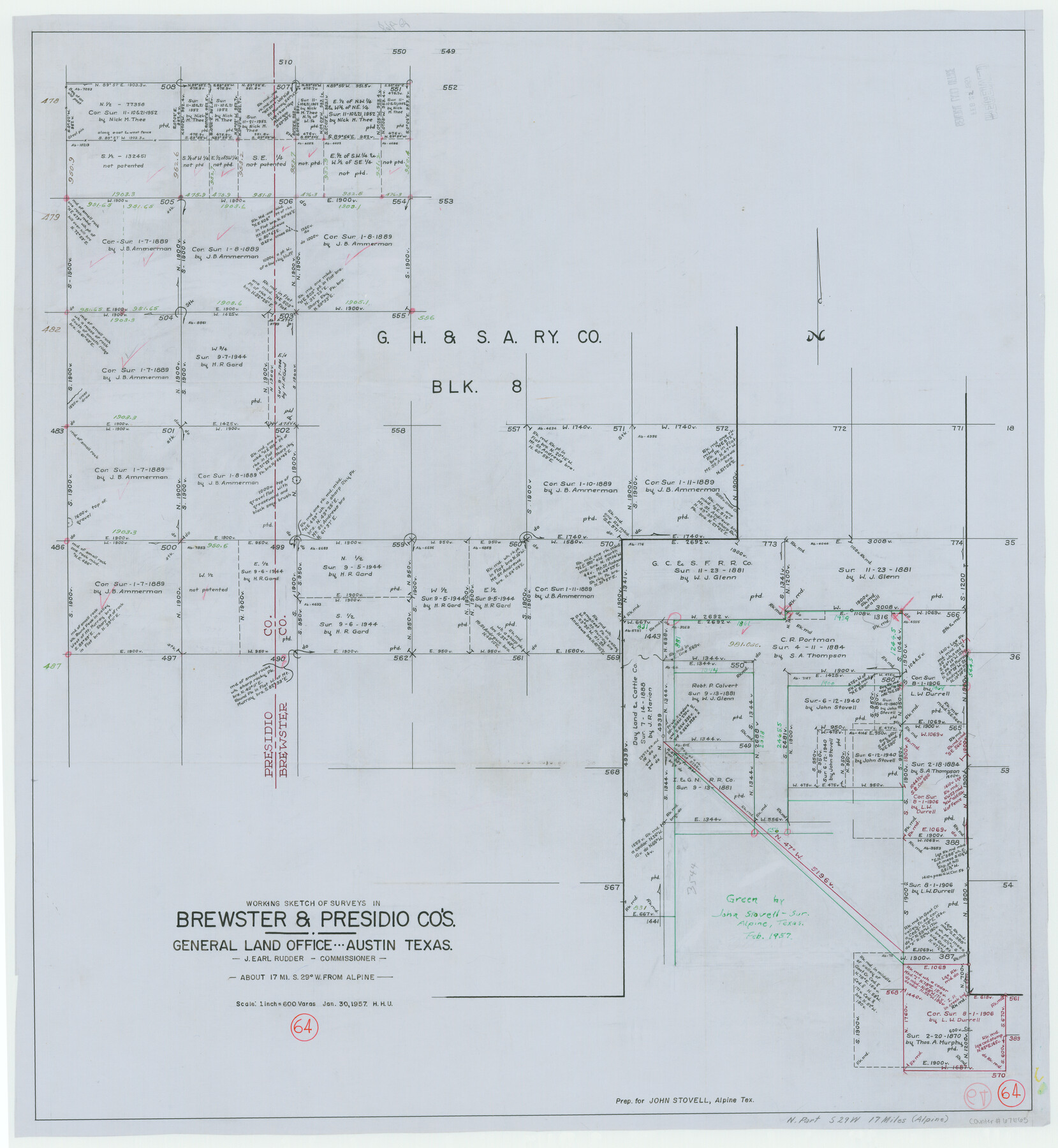
Brewster County Working Sketch 64
-
Map/Doc
67665
-
Collection
General Map Collection
-
Object Dates
1/30/1957 (Creation Date)
-
People and Organizations
Herbert H. Ulbricht (Draftsman)
-
Counties
Brewster Presidio
-
Subjects
Surveying Working Sketch
-
Height x Width
31.8 x 29.3 inches
80.8 x 74.4 cm
-
Scale
1" = 600 varas
Part of: General Map Collection

Trinity River, Wire Bridge Sheet/Denton Creek

Print $6.00
- Digital $50.00
Trinity River, Wire Bridge Sheet/Denton Creek
1938
Size 30.4 x 29.7 inches
Map/Doc 65244
Aransas County Sketch File 18

Print $8.00
- Digital $50.00
Aransas County Sketch File 18
1888
Size 12.7 x 8.2 inches
Map/Doc 13149
Flight Mission No. BQR-14K, Frame 37, Brazoria County

Print $20.00
- Digital $50.00
Flight Mission No. BQR-14K, Frame 37, Brazoria County
1952
Size 18.6 x 22.2 inches
Map/Doc 84094
Coryell County Sketch File 17

Print $4.00
- Digital $50.00
Coryell County Sketch File 17
1854
Size 6.7 x 8.4 inches
Map/Doc 19375
Harris County NRC Article 33.136 Sketch 8

Print $68.00
- Digital $50.00
Harris County NRC Article 33.136 Sketch 8
2000
Size 30.0 x 42.5 inches
Map/Doc 83087
Webb County Sketch File 44b-1

Print $20.00
- Digital $50.00
Webb County Sketch File 44b-1
1936
Size 29.0 x 18.0 inches
Map/Doc 12641
Garza County Sketch File 25

Print $4.00
- Digital $50.00
Garza County Sketch File 25
1907
Size 7.6 x 7.9 inches
Map/Doc 24086
Castro County Sketch File 2

Print $20.00
- Digital $50.00
Castro County Sketch File 2
Size 24.7 x 17.7 inches
Map/Doc 11057
Denton County Rolled Sketch 2

Print $40.00
- Digital $50.00
Denton County Rolled Sketch 2
1933
Size 47.1 x 53.5 inches
Map/Doc 8338
Flight Mission No. DQN-2K, Frame 119, Calhoun County

Print $20.00
- Digital $50.00
Flight Mission No. DQN-2K, Frame 119, Calhoun County
1953
Size 16.8 x 16.5 inches
Map/Doc 84295
Fayette County Working Sketch 7

Print $20.00
- Digital $50.00
Fayette County Working Sketch 7
1981
Size 24.1 x 15.6 inches
Map/Doc 69171
You may also like
McLennan County Sketch File 25

Print $2.00
- Digital $50.00
McLennan County Sketch File 25
Size 8.8 x 12.3 inches
Map/Doc 31299
Segunda parte del Mapa, que comprende la Frontera, de los Dominios del Rey, en la America Septentrional

Print $40.00
- Digital $50.00
Segunda parte del Mapa, que comprende la Frontera, de los Dominios del Rey, en la America Septentrional
1769
Size 26.7 x 63.8 inches
Map/Doc 4667
Map of Comal County

Print $20.00
- Digital $50.00
Map of Comal County
1897
Size 40.4 x 46.3 inches
Map/Doc 4917
Howard County Sketch File 8

Print $3.00
- Digital $50.00
Howard County Sketch File 8
Size 20.8 x 18.7 inches
Map/Doc 11796
Duval County Working Sketch 44

Print $20.00
- Digital $50.00
Duval County Working Sketch 44
1977
Size 27.5 x 40.7 inches
Map/Doc 68768
Zapata County Working Sketch 19

Print $40.00
- Digital $50.00
Zapata County Working Sketch 19
1976
Size 41.2 x 55.5 inches
Map/Doc 62070
Terrell County

Print $20.00
- Digital $50.00
Terrell County
1905
Size 41.6 x 30.9 inches
Map/Doc 63061
Cherokee County Boundary File 2

Print $11.00
- Digital $50.00
Cherokee County Boundary File 2
Size 16.1 x 9.9 inches
Map/Doc 51280
The Republic County of Brazoria. January 1, 1838

Print $20.00
The Republic County of Brazoria. January 1, 1838
2020
Size 14.7 x 21.8 inches
Map/Doc 96111
Map of the River Sabine from its mouth on the Gulf of Mexico in the Sea to Logan's Ferry in Latitude 31°58'24" North

Print $20.00
- Digital $50.00
Map of the River Sabine from its mouth on the Gulf of Mexico in the Sea to Logan's Ferry in Latitude 31°58'24" North
1842
Size 47.9 x 30.6 inches
Map/Doc 87150
[Sketch for Mineral Application 1112 - Colorado River, H. E. Chambers]
![65638, [Sketch for Mineral Application 1112 - Colorado River, H. E. Chambers], General Map Collection](https://historictexasmaps.com/wmedia_w700/maps/65638.tif.jpg)
Print $20.00
- Digital $50.00
[Sketch for Mineral Application 1112 - Colorado River, H. E. Chambers]
1918
Size 17.5 x 28.2 inches
Map/Doc 65638
Outer Continental Shelf Leasing Maps (Texas Offshore Operations)

Print $20.00
- Digital $50.00
Outer Continental Shelf Leasing Maps (Texas Offshore Operations)
Size 24.0 x 18.4 inches
Map/Doc 75853