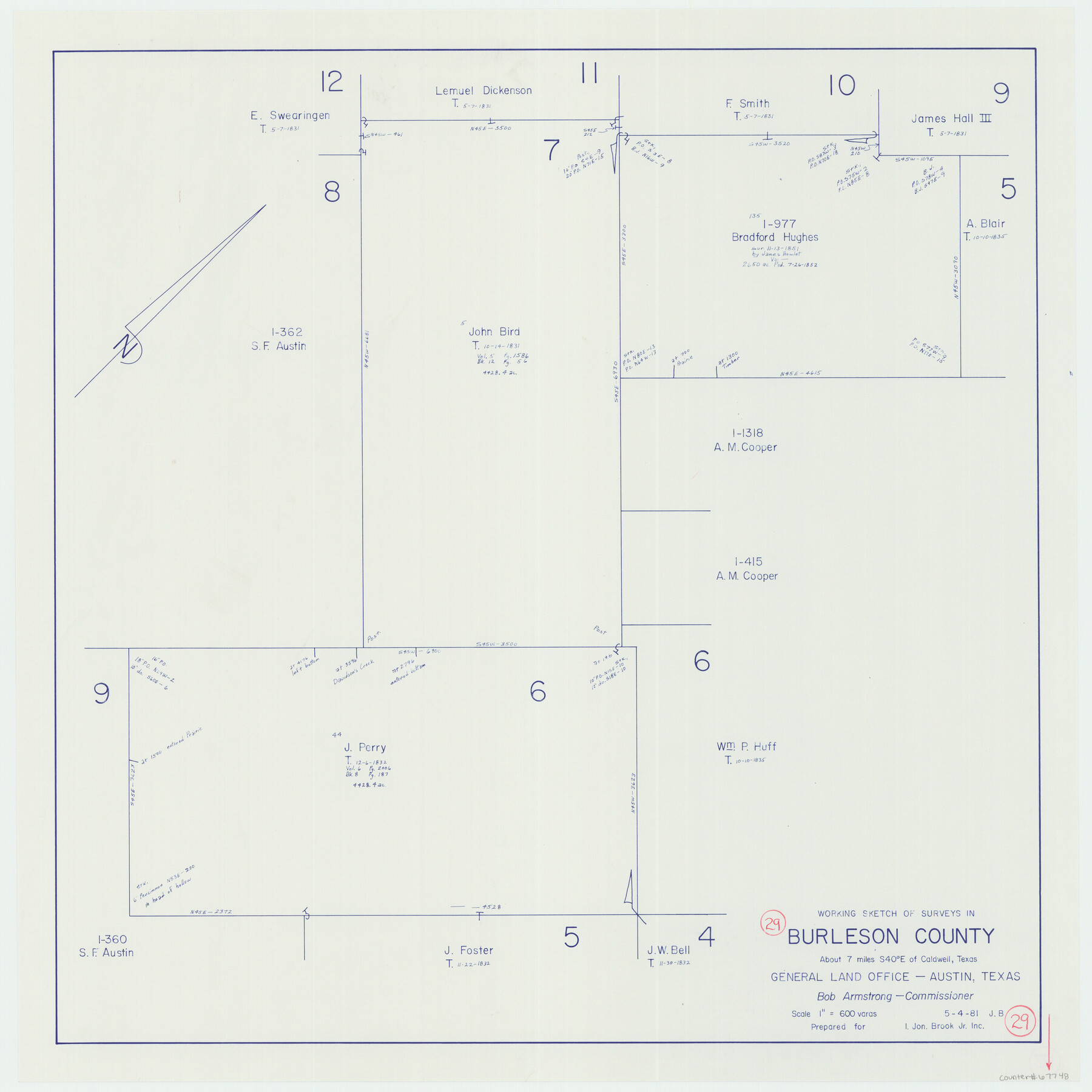
Burleson County Working Sketch 29
-
Map/Doc
67748
-
Collection
General Map Collection
-
Object Dates
5/4/1981 (Creation Date)
-
Counties
Burleson
-
Subjects
Surveying Working Sketch
-
Height x Width
24.7 x 24.7 inches
62.7 x 62.7 cm
-
Scale
1" = 600 varas
Part of: General Map Collection
Freestone County Sketch File 4

Print $6.00
- Digital $50.00
Freestone County Sketch File 4
1848
Size 10.8 x 8.2 inches
Map/Doc 23044
McMullen County Sketch File 31

Print $20.00
- Digital $50.00
McMullen County Sketch File 31
Size 44.7 x 15.6 inches
Map/Doc 10541
Frio County Working Sketch 13

Print $20.00
- Digital $50.00
Frio County Working Sketch 13
1954
Size 23.3 x 35.5 inches
Map/Doc 69287
Jim Hogg County Working Sketch 11

Print $20.00
- Digital $50.00
Jim Hogg County Working Sketch 11
1979
Size 24.7 x 37.6 inches
Map/Doc 66597

Brazoria County Working Sketch 36

Print $40.00
- Digital $50.00
Brazoria County Working Sketch 36
1981
Size 43.4 x 71.4 inches
Map/Doc 67521
Comal County Working Sketch 9

Print $20.00
- Digital $50.00
Comal County Working Sketch 9
1972
Size 29.0 x 30.4 inches
Map/Doc 68175
Gaines County Rolled Sketch 15C

Print $20.00
- Digital $50.00
Gaines County Rolled Sketch 15C
Size 33.6 x 22.7 inches
Map/Doc 75929
Fannin County Texas

Print $20.00
- Digital $50.00
Fannin County Texas
1870
Size 23.9 x 19.3 inches
Map/Doc 4542
Refugio County Sketch File 8b

Print $4.00
- Digital $50.00
Refugio County Sketch File 8b
1876
Size 8.5 x 10.5 inches
Map/Doc 35254
Live Oak County Sketch File 21

Print $26.00
- Digital $50.00
Live Oak County Sketch File 21
1912
Size 16.8 x 8.0 inches
Map/Doc 30297
Flight Mission No. DQO-2K, Frame 85, Galveston County

Print $20.00
- Digital $50.00
Flight Mission No. DQO-2K, Frame 85, Galveston County
1952
Size 18.9 x 22.5 inches
Map/Doc 85012
You may also like
Hudspeth County Working Sketch 5

Print $20.00
- Digital $50.00
Hudspeth County Working Sketch 5
1921
Size 27.8 x 38.8 inches
Map/Doc 66286
[Sketch for Mineral Application 20124, North Fork of Red River]
![2826, [Sketch for Mineral Application 20124, North Fork of Red River], General Map Collection](https://historictexasmaps.com/wmedia_w700/maps/2826.tif.jpg)
Print $20.00
- Digital $50.00
[Sketch for Mineral Application 20124, North Fork of Red River]
1943
Size 18.5 x 26.0 inches
Map/Doc 2826
Pecos County Rolled Sketch 189

Print $20.00
- Digital $50.00
Pecos County Rolled Sketch 189
1998
Size 22.2 x 33.7 inches
Map/Doc 7307
Upton County Sketch File S

Print $8.00
- Digital $50.00
Upton County Sketch File S
Size 13.4 x 9.1 inches
Map/Doc 38850
T. & P. RR. Co. Township 1 South, Block 44

Print $20.00
- Digital $50.00
T. & P. RR. Co. Township 1 South, Block 44
Size 20.1 x 29.3 inches
Map/Doc 90901
Pecos County Rolled Sketch 114

Print $856.00
- Digital $50.00
Pecos County Rolled Sketch 114
1942
Size 11.0 x 15.4 inches
Map/Doc 48104
Hardeman County Working Sketch 16

Print $20.00
- Digital $50.00
Hardeman County Working Sketch 16
1982
Size 35.7 x 45.1 inches
Map/Doc 63397
Sutton County Working Sketch 62

Print $20.00
- Digital $50.00
Sutton County Working Sketch 62
1959
Size 31.3 x 38.1 inches
Map/Doc 62405
Pecan Bayou Travis District

Print $20.00
- Digital $50.00
Pecan Bayou Travis District
1852
Size 25.8 x 20.5 inches
Map/Doc 4518
Ellis County Sketch File 1

Print $6.00
- Digital $50.00
Ellis County Sketch File 1
1849
Size 6.5 x 7.9 inches
Map/Doc 21824
Webb County Rolled Sketch 38

Print $20.00
- Digital $50.00
Webb County Rolled Sketch 38
1940
Size 22.2 x 16.0 inches
Map/Doc 8193
Isham Tubbs Estate

Print $3.00
- Digital $50.00
Isham Tubbs Estate
1947
Size 15.5 x 9.3 inches
Map/Doc 92304