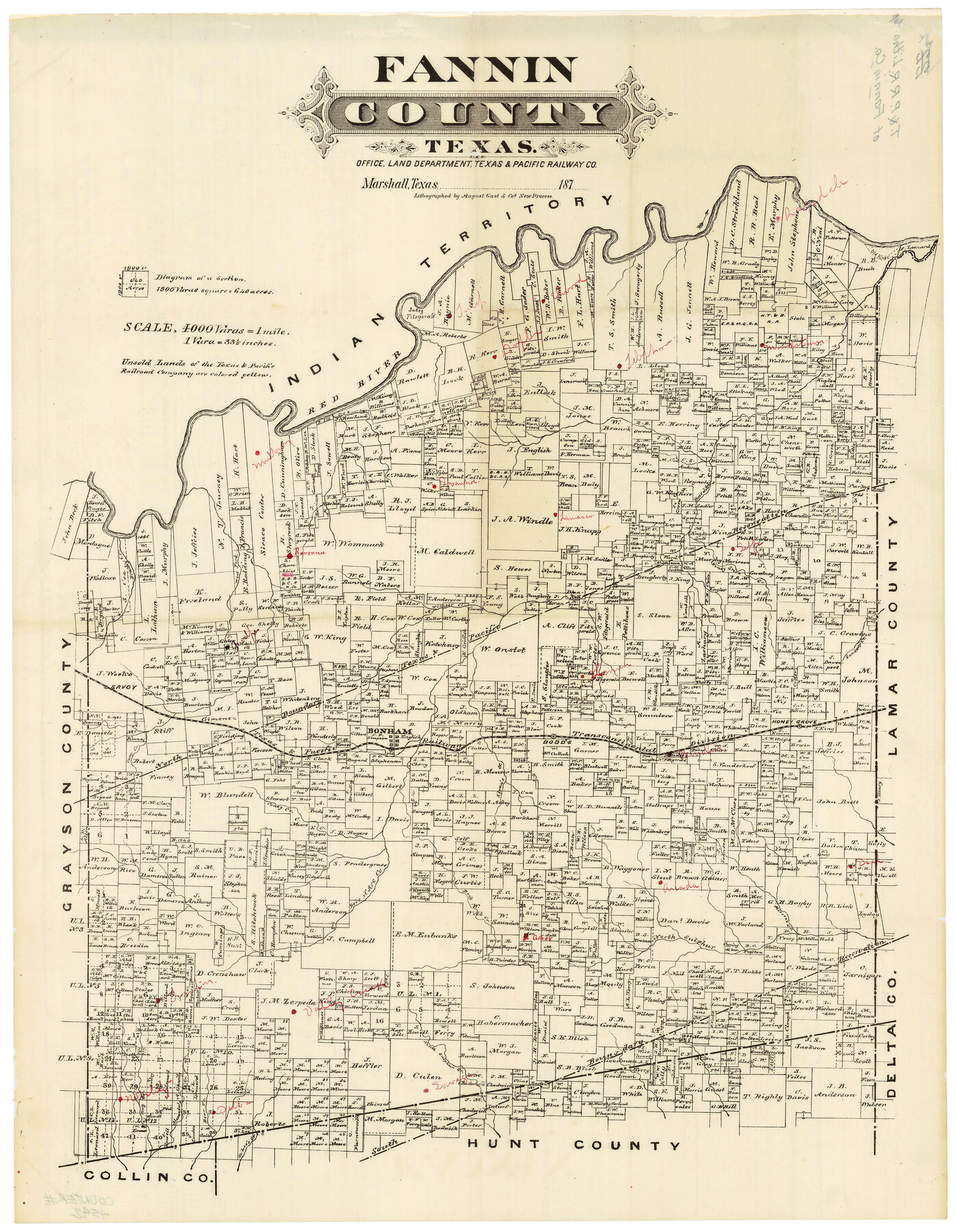
Fannin County Texas
Fannin County Sketch File 23
-
Map/Doc
4542
-
Collection
General Map Collection
-
Object Dates
1870 (Creation Date)
-
People and Organizations
Texas and Pacific Railroad Co., Marshall, Texas (Publisher)
August Gast & Co. (Lithographer)
-
Counties
Fannin
-
Subjects
County
-
Height x Width
23.9 x 19.3 inches
60.7 x 49.0 cm
-
Scale
1" = 4000 varas
-
Comments
Scale incorrectly stated as "4000 varas=1 mile"
"Lithographed by August Gast & Co's new process."
Note on back: "Texas and Pacific Railroad Litho Map of Fannin County".
Locations of many small towns added in red pen. Formerly filed as Fannin County Sketch File 23. -
Features
Gober
Sloan's Creek
Bonham
Caney Creek
Trenton
Rock Creek
Arcada [sic]
Mercen's Creek
Dial
North Sulphur Creek
Windam
Webb Creek
Valley Creek
South Sulphur Creek
Sulphur Creek
Savage
D. Lee's Creek
Bear Creek
Alexander's Creek
Bois D'Arc Creek
Red River
Tulip
Duplex
Elwood
Telephone
Mulberry
Ivanhoe
Lamar
Ragsdale
Honey Grove Creek
Self
Sander's Creek
Timber Creek
Brushy Creek
Savoy
Dodds
Honey Grove
Part of: General Map Collection
Angelina County Working Sketch 55

Print $20.00
- Digital $50.00
Angelina County Working Sketch 55
1989
Size 33.7 x 30.0 inches
Map/Doc 67139
King County Working Sketch 4

Print $20.00
- Digital $50.00
King County Working Sketch 4
1939
Size 42.9 x 25.7 inches
Map/Doc 70168
Flight Mission No. BQY-4M, Frame 123, Harris County

Print $20.00
- Digital $50.00
Flight Mission No. BQY-4M, Frame 123, Harris County
1953
Size 18.7 x 22.4 inches
Map/Doc 85291
MKT (Missouri Kansas Texas) Katy Railroad Time Tables

Print $54.00
- Digital $50.00
MKT (Missouri Kansas Texas) Katy Railroad Time Tables
1946
Size 9.3 x 16.4 inches
Map/Doc 93981
Ward County Working Sketch 54

Print $40.00
- Digital $50.00
Ward County Working Sketch 54
1978
Size 24.1 x 48.8 inches
Map/Doc 72360
Terrell County Working Sketch 18a

Print $40.00
- Digital $50.00
Terrell County Working Sketch 18a
1931
Size 48.9 x 34.6 inches
Map/Doc 62168
Map of the State of Coahuila and Texas

Map of the State of Coahuila and Texas
1834
Size 13.3 x 14.9 inches
Map/Doc 96969
Coleman County Sketch File 32

Print $4.00
- Digital $50.00
Coleman County Sketch File 32
Size 12.8 x 8.4 inches
Map/Doc 18723
Flight Mission No. DQN-6K, Frame 8, Calhoun County

Print $20.00
- Digital $50.00
Flight Mission No. DQN-6K, Frame 8, Calhoun County
1953
Size 18.5 x 22.1 inches
Map/Doc 84430
Jack County Working Sketch 23

Print $20.00
- Digital $50.00
Jack County Working Sketch 23
2006
Size 18.4 x 22.0 inches
Map/Doc 83606
Andrews County Working Sketch 25

Print $40.00
- Digital $50.00
Andrews County Working Sketch 25
1980
Size 70.6 x 44.0 inches
Map/Doc 67071
Eastland County Sketch File 5

Print $4.00
- Digital $50.00
Eastland County Sketch File 5
Size 6.4 x 7.1 inches
Map/Doc 21570
You may also like
Leon County Working Sketch 44

Print $40.00
- Digital $50.00
Leon County Working Sketch 44
1980
Size 42.8 x 59.8 inches
Map/Doc 70443
Flight Mission No. DQN-1K, Frame 73, Calhoun County

Print $20.00
- Digital $50.00
Flight Mission No. DQN-1K, Frame 73, Calhoun County
1953
Size 18.5 x 22.2 inches
Map/Doc 84160
Matagorda County Working Sketch 4

Print $20.00
- Digital $50.00
Matagorda County Working Sketch 4
1908
Size 33.1 x 32.0 inches
Map/Doc 70862
Right of Way & Track Map, St. Louis, Brownsville & Mexico Ry. operated by St. Louis, Brownsville & Mexico Ry. Co.

Print $40.00
- Digital $50.00
Right of Way & Track Map, St. Louis, Brownsville & Mexico Ry. operated by St. Louis, Brownsville & Mexico Ry. Co.
1919
Size 25.5 x 57.1 inches
Map/Doc 64624
Plano de la Sauteña. Indicando los terrenos irrigados en Texas

Plano de la Sauteña. Indicando los terrenos irrigados en Texas
Size 38.6 x 37.8 inches
Map/Doc 94566
Harris County Rolled Sketch O

Print $20.00
- Digital $50.00
Harris County Rolled Sketch O
1913
Size 16.0 x 24.5 inches
Map/Doc 6140
Map of The Surveyed Part of Peters Colony Texas

Print $40.00
- Digital $50.00
Map of The Surveyed Part of Peters Colony Texas
1858
Size 45.6 x 58.5 inches
Map/Doc 1982
Flight Mission No. CLL-3N, Frame 36, Willacy County

Print $20.00
- Digital $50.00
Flight Mission No. CLL-3N, Frame 36, Willacy County
1954
Size 18.4 x 22.2 inches
Map/Doc 87094
Medina County

Print $40.00
- Digital $50.00
Medina County
1976
Size 52.5 x 43.2 inches
Map/Doc 73237
Runnels County Rolled Sketch 54

Print $20.00
- Digital $50.00
Runnels County Rolled Sketch 54
Size 11.5 x 18.2 inches
Map/Doc 82576
Montgomery County Working Sketch 8b

Print $20.00
- Digital $50.00
Montgomery County Working Sketch 8b
1932
Size 17.7 x 20.7 inches
Map/Doc 71115
Matagorda County Sketch File 43

Print $20.00
- Digital $50.00
Matagorda County Sketch File 43
1839
Size 13.2 x 8.2 inches
Map/Doc 30868