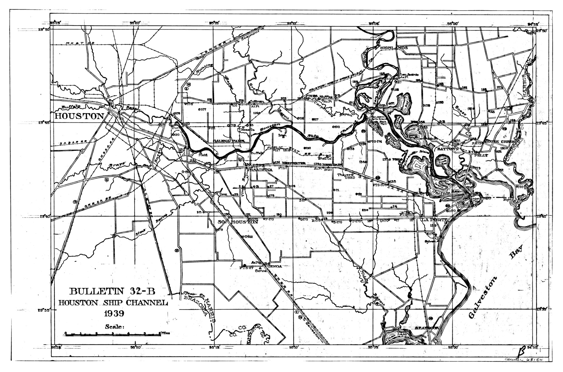
San Jacinto River, Houston Ship Channel
-
Map/Doc
65150
-
Collection
General Map Collection
-
Object Dates
1939 (Creation Date)
-
People and Organizations
Texas State Reclamation Department (Publisher)
-
Counties
Harris
-
Subjects
River Surveys Topographic
-
Height x Width
11.7 x 17.7 inches
29.7 x 45.0 cm
-
Comments
Named Features continued: Channel: Houston Ship
Lakes: Crystal, Peggy, Lost, Clear
Bays: Scott, Burnett, Galveston, San Jacinto, Black Duck, Tabbs
Bayous: Buffalo, Brays, Sims, Hunting, Greens, Cedar, Middle
Creeks: Goose, Clear
Islan
Part of: General Map Collection
Routes to HemisFair '68 : World's Fair, San Antonio, Texas, April 6 through Oct. 6, 1968 [Recto]
![94168, Hemisfair Gulf Tourgide Map [Recto], General Map Collection](https://historictexasmaps.com/wmedia_w700/maps/94168.tif.jpg)
Routes to HemisFair '68 : World's Fair, San Antonio, Texas, April 6 through Oct. 6, 1968 [Recto]
Size 18.2 x 24.2 inches
Map/Doc 94168
Nueces County NRC Article 33.136 Sketch 25

Print $36.00
Nueces County NRC Article 33.136 Sketch 25
2025
Map/Doc 97513
Gaines County Rolled Sketch 14

Print $40.00
- Digital $50.00
Gaines County Rolled Sketch 14
Size 23.8 x 325.9 inches
Map/Doc 9030
Right of Way & Track Map, St. Louis, Brownsville & Mexico Ry. operated by St. Louis, Brownsville & Mexico Ry. Co.

Print $40.00
- Digital $50.00
Right of Way & Track Map, St. Louis, Brownsville & Mexico Ry. operated by St. Louis, Brownsville & Mexico Ry. Co.
1919
Size 25.5 x 57.3 inches
Map/Doc 64622
Childress County Boundary File 1

Print $2.00
- Digital $50.00
Childress County Boundary File 1
Size 8.9 x 3.8 inches
Map/Doc 51305
Colorado River, New Gulf Sheet

Print $6.00
- Digital $50.00
Colorado River, New Gulf Sheet
1940
Size 24.0 x 34.9 inches
Map/Doc 65315
Potter County Sketch File 4

Print $10.00
- Digital $50.00
Potter County Sketch File 4
1882
Size 14.1 x 8.6 inches
Map/Doc 34382
Cherokee County Working Sketch 13

Print $20.00
- Digital $50.00
Cherokee County Working Sketch 13
1957
Size 46.5 x 43.8 inches
Map/Doc 67968
Val Verde County Rolled Sketch 84

Print $20.00
- Digital $50.00
Val Verde County Rolled Sketch 84
2006
Size 31.2 x 35.4 inches
Map/Doc 84802
Map of Parker County

Print $20.00
- Digital $50.00
Map of Parker County
1879
Size 23.9 x 19.0 inches
Map/Doc 3947
Mustang Island

Print $20.00
- Digital $50.00
Mustang Island
1945
Size 42.8 x 42.6 inches
Map/Doc 77469
Brewster County Sketch File N-13

Print $8.00
- Digital $50.00
Brewster County Sketch File N-13
1935
Size 14.3 x 8.7 inches
Map/Doc 15625
You may also like
Hood County Rolled Sketch 4

Print $20.00
- Digital $50.00
Hood County Rolled Sketch 4
Size 33.4 x 43.1 inches
Map/Doc 6220
Map of the Middle States and part of the Southern engraved to illustrate Mitchell's school and family geography

Print $20.00
- Digital $50.00
Map of the Middle States and part of the Southern engraved to illustrate Mitchell's school and family geography
1839
Size 17.8 x 11.8 inches
Map/Doc 93496
Flight Mission No. DCL-7C, Frame 110, Kenedy County

Print $20.00
- Digital $50.00
Flight Mission No. DCL-7C, Frame 110, Kenedy County
1943
Size 18.5 x 22.3 inches
Map/Doc 86075
Knox County Working Sketch 11

Print $20.00
- Digital $50.00
Knox County Working Sketch 11
1950
Size 16.8 x 29.0 inches
Map/Doc 70253
Comanche County Working Sketch 12

Print $20.00
- Digital $50.00
Comanche County Working Sketch 12
1957
Size 15.4 x 25.5 inches
Map/Doc 68146
Dimmit County Working Sketch 42

Print $20.00
- Digital $50.00
Dimmit County Working Sketch 42
1977
Size 33.5 x 39.6 inches
Map/Doc 68703

[Blocks N and B]
![90498, [Blocks N and B], Twichell Survey Records](https://historictexasmaps.com/wmedia_w700/maps/90498-1.tif.jpg)
Print $3.00
- Digital $50.00
[Blocks N and B]
Size 10.0 x 11.4 inches
Map/Doc 90498
Culberson County Working Sketch 47

Print $20.00
- Digital $50.00
Culberson County Working Sketch 47
1971
Size 25.7 x 36.5 inches
Map/Doc 68501
Collin County Working Sketch Graphic Index

Print $20.00
- Digital $50.00
Collin County Working Sketch Graphic Index
1975
Size 41.4 x 39.0 inches
Map/Doc 76498
[Northeast Portion of Hartley County]
![91118, [Northeast Portion of Hartley County], Twichell Survey Records](https://historictexasmaps.com/wmedia_w700/maps/91118-1.tif.jpg)
Print $2.00
- Digital $50.00
[Northeast Portion of Hartley County]
Size 13.9 x 8.5 inches
Map/Doc 91118
Americae Sive Novi Orbis, Nova Descriptio

Print $20.00
- Digital $50.00
Americae Sive Novi Orbis, Nova Descriptio
1573
Size 15.6 x 22.3 inches
Map/Doc 95834