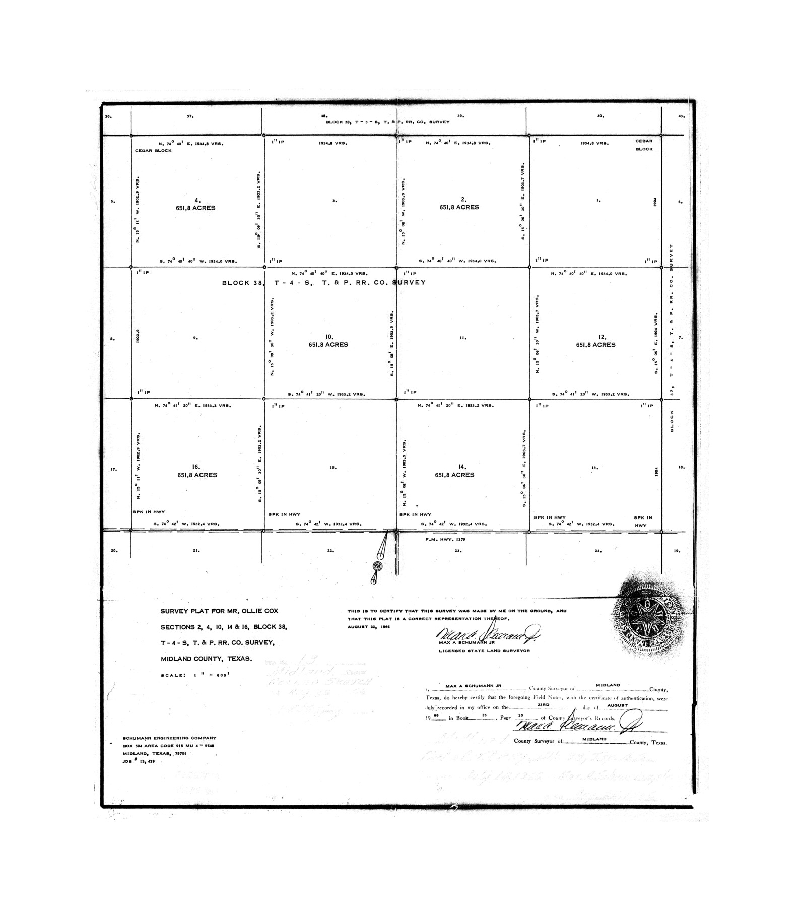
Midland County Rolled Sketch 13
Survey plat for Mr. Ollie Cox, sections 2, 4, 10, 14, & 16, Block 38, T-4-S, T. & P. R.R. Co. survey, Midland County, Texas
-
Map/Doc
6768
-
Collection
General Map Collection
-
Object Dates
1966/8/22 (File Date)
-
People and Organizations
Max A. Schumann, Jr. (Surveyor/Engineer)
-
Counties
Midland
-
Subjects
Surveying Rolled Sketch
-
Height x Width
22.0 x 19.4 inches
55.9 x 49.3 cm
-
Scale
1" = 600 feet
Part of: General Map Collection
Nueces County Rolled Sketch 113B

Print $20.00
- Digital $50.00
Nueces County Rolled Sketch 113B
1972
Size 18.6 x 24.2 inches
Map/Doc 7123
Coryell County Working Sketch 3

Print $20.00
- Digital $50.00
Coryell County Working Sketch 3
1928
Size 23.6 x 22.5 inches
Map/Doc 68210
City of Alpine - Texas, Brewster County

Print $20.00
- Digital $50.00
City of Alpine - Texas, Brewster County
1945
Size 11.4 x 19.4 inches
Map/Doc 1683
Coke County Sketch File 25

Print $34.00
- Digital $50.00
Coke County Sketch File 25
1930
Size 14.2 x 8.9 inches
Map/Doc 18618
Montgomery County Working Sketch 19

Print $20.00
- Digital $50.00
Montgomery County Working Sketch 19
1935
Size 31.8 x 36.6 inches
Map/Doc 71126
Concho County Boundary File 4

Print $2.00
- Digital $50.00
Concho County Boundary File 4
Size 12.7 x 8.4 inches
Map/Doc 51825
Runnels County Rolled Sketch 37

Print $20.00
- Digital $50.00
Runnels County Rolled Sketch 37
Size 37.8 x 38.2 inches
Map/Doc 9870
Loving County State of Texas

Print $20.00
- Digital $50.00
Loving County State of Texas
1889
Size 20.6 x 24.3 inches
Map/Doc 4582
Hays County Sketch File 17

Print $8.00
- Digital $50.00
Hays County Sketch File 17
1877
Size 12.9 x 8.4 inches
Map/Doc 26231
McCulloch County Working Sketch 15

Print $20.00
- Digital $50.00
McCulloch County Working Sketch 15
1994
Size 33.2 x 34.0 inches
Map/Doc 70690
Flight Mission No. DIX-7P, Frame 86, Aransas County

Print $20.00
- Digital $50.00
Flight Mission No. DIX-7P, Frame 86, Aransas County
1956
Size 18.7 x 22.5 inches
Map/Doc 83880
Collin County Sketch File 3

Print $20.00
- Digital $50.00
Collin County Sketch File 3
1852
Size 19.5 x 21.4 inches
Map/Doc 11126
You may also like
Bosque County Working Sketch 17

Print $20.00
- Digital $50.00
Bosque County Working Sketch 17
1975
Size 18.3 x 21.1 inches
Map/Doc 67450
Lavaca County Working Sketch 24

Print $20.00
- Digital $50.00
Lavaca County Working Sketch 24
1985
Size 29.5 x 35.7 inches
Map/Doc 70377
[E. T. Ry. Blk. 1]
![89796, [E. T. Ry. Blk. 1], Twichell Survey Records](https://historictexasmaps.com/wmedia_w700/maps/89796-1.tif.jpg)
Print $40.00
- Digital $50.00
[E. T. Ry. Blk. 1]
Size 41.1 x 50.4 inches
Map/Doc 89796
Cottle County Sketch File 15

Print $4.00
- Digital $50.00
Cottle County Sketch File 15
1891
Size 11.2 x 9.0 inches
Map/Doc 19516
Pecos County Working Sketch Graphic Index - northeast part - sheet B

Print $20.00
- Digital $50.00
Pecos County Working Sketch Graphic Index - northeast part - sheet B
1975
Size 36.0 x 42.2 inches
Map/Doc 76667
Flight Mission No. DAH-17M, Frame 23, Orange County

Print $20.00
- Digital $50.00
Flight Mission No. DAH-17M, Frame 23, Orange County
1953
Size 18.7 x 22.5 inches
Map/Doc 86886
Plat of Division 3 of Day Ranch Lands, Leaday, Texas

Print $20.00
- Digital $50.00
Plat of Division 3 of Day Ranch Lands, Leaday, Texas
Size 20.4 x 21.8 inches
Map/Doc 81514
Trinity River, Emhouse Sheet/Chambers Creek

Print $6.00
- Digital $50.00
Trinity River, Emhouse Sheet/Chambers Creek
1931
Size 35.3 x 34.8 inches
Map/Doc 65232
Medina County Working Sketch Graphic Index

Print $40.00
- Digital $50.00
Medina County Working Sketch Graphic Index
1976
Size 52.8 x 42.8 inches
Map/Doc 76639
General Highway Map, Fisher County, Texas

Print $20.00
General Highway Map, Fisher County, Texas
1961
Size 18.1 x 24.7 inches
Map/Doc 79466
The Mexican Municipality of Mina. January 11, 1836

Print $20.00
The Mexican Municipality of Mina. January 11, 1836
2020
Size 10.7 x 21.7 inches
Map/Doc 96030
Tyler County Sketch File 6-2

Print $20.00
- Digital $50.00
Tyler County Sketch File 6-2
1861
Size 16.8 x 22.5 inches
Map/Doc 12498