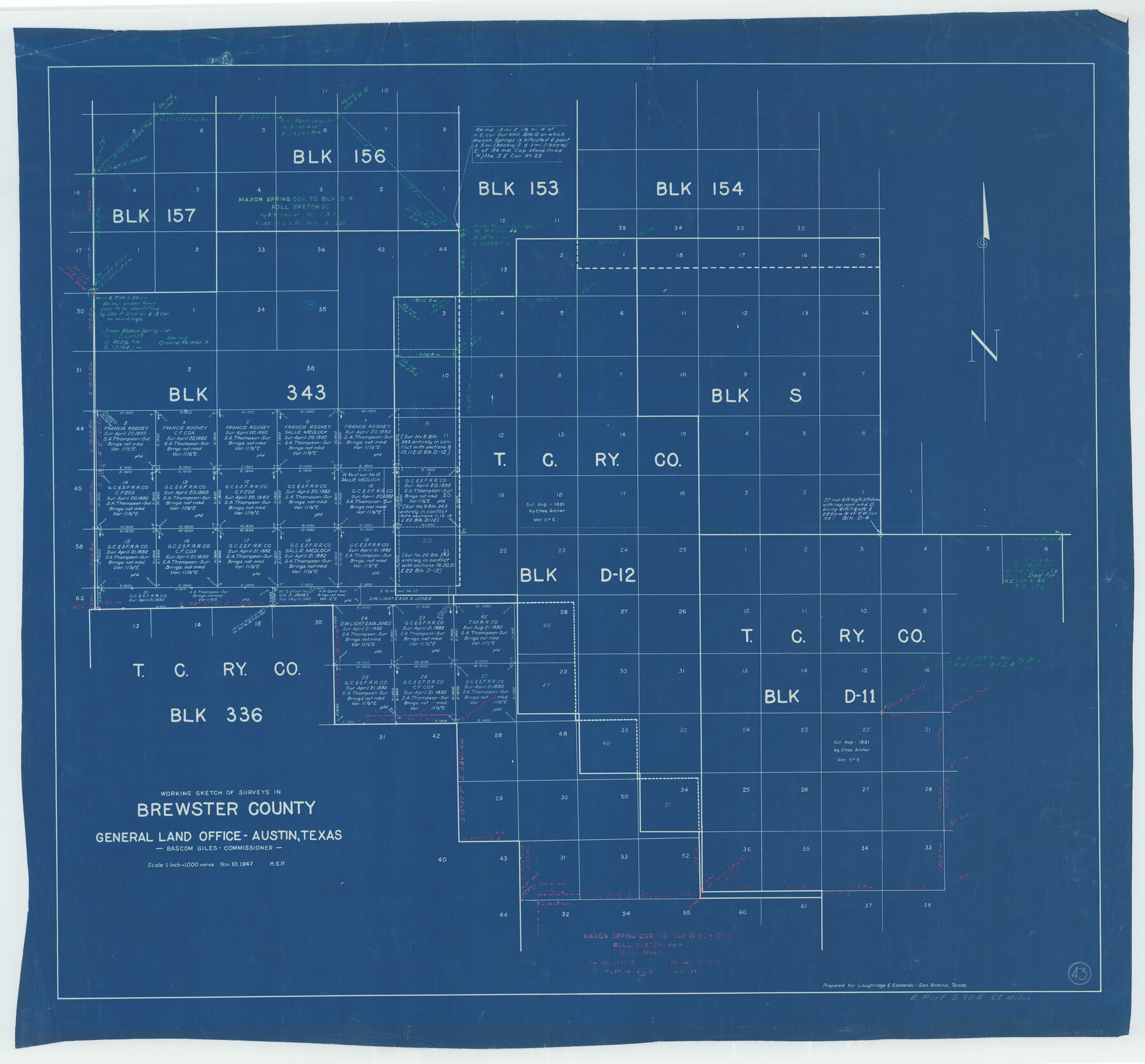
Brewster County Working Sketch 43
-
Map/Doc
67577
-
Collection
General Map Collection
-
Object Dates
11/10/1947 (Creation Date)
-
Counties
Brewster
-
Subjects
Surveying Working Sketch
-
Height x Width
33.7 x 36.2 inches
85.6 x 92.0 cm
-
Scale
1" = 1000 varas
Part of: General Map Collection
Jefferson County Rolled Sketch 17

Print $40.00
- Digital $50.00
Jefferson County Rolled Sketch 17
1931
Size 18.7 x 72.6 inches
Map/Doc 9281
The Absolem C. De La Plain League and Labor of Land

Print $20.00
- Digital $50.00
The Absolem C. De La Plain League and Labor of Land
2013
Size 30.0 x 24.0 inches
Map/Doc 93425
Harrison County Boundary File 41 (10)

Print $10.00
- Digital $50.00
Harrison County Boundary File 41 (10)
Size 7.1 x 3.4 inches
Map/Doc 54418
Galveston County NRC Article 33.136 Sketch 59

Print $24.00
- Digital $50.00
Galveston County NRC Article 33.136 Sketch 59
2008
Size 11.5 x 17.0 inches
Map/Doc 94606
Cameron County Sketch File 14

Print $38.00
- Digital $50.00
Cameron County Sketch File 14
1993
Size 11.2 x 8.8 inches
Map/Doc 17311
Dickens County Sketch File 3

Print $6.00
- Digital $50.00
Dickens County Sketch File 3
1880
Size 6.9 x 6.4 inches
Map/Doc 20959
Kimble County Sketch File 11

Print $40.00
- Digital $50.00
Kimble County Sketch File 11
1882
Size 20.5 x 10.2 inches
Map/Doc 28933
Pecos County Sketch File 93

Print $46.00
- Digital $50.00
Pecos County Sketch File 93
1955
Size 9.6 x 8.3 inches
Map/Doc 33990
Brewster County Boundary File 1b

Print $32.00
- Digital $50.00
Brewster County Boundary File 1b
Size 9.2 x 11.3 inches
Map/Doc 50740
Flight Mission No. CGI-3N, Frame 131, Cameron County

Print $20.00
- Digital $50.00
Flight Mission No. CGI-3N, Frame 131, Cameron County
1954
Size 18.7 x 22.3 inches
Map/Doc 84604
Wichita County Sketch File 36

Print $20.00
- Digital $50.00
Wichita County Sketch File 36
1894
Size 20.1 x 25.9 inches
Map/Doc 12689
Terrell County Rolled Sketch 49

Print $20.00
- Digital $50.00
Terrell County Rolled Sketch 49
1962
Size 17.3 x 24.1 inches
Map/Doc 7951
You may also like
Bowie County Sketch File 8

Print $42.00
- Digital $50.00
Bowie County Sketch File 8
1927
Size 8.9 x 3.8 inches
Map/Doc 14872
[Blocks 2, M3, M20, G. & M. Block 22 and others in the vicinity]
![91803, [Blocks 2, M3, M20, G. & M. Block 22 and others in the vicinity], Twichell Survey Records](https://historictexasmaps.com/wmedia_w700/maps/91803-1.tif.jpg)
Print $20.00
- Digital $50.00
[Blocks 2, M3, M20, G. & M. Block 22 and others in the vicinity]
Size 19.0 x 23.2 inches
Map/Doc 91803
Flight Mission No. DQN-2K, Frame 5, Calhoun County

Print $20.00
- Digital $50.00
Flight Mission No. DQN-2K, Frame 5, Calhoun County
1953
Size 18.5 x 22.2 inches
Map/Doc 84222
[Sketch of San Antonio del Encinal, Hidalgo County, Texas]
![4457, [Sketch of San Antonio del Encinal, Hidalgo County, Texas], Maddox Collection](https://historictexasmaps.com/wmedia_w700/maps/4457-1.tif.jpg)
Print $20.00
- Digital $50.00
[Sketch of San Antonio del Encinal, Hidalgo County, Texas]
Size 12.1 x 27.1 inches
Map/Doc 4457
Upshur County Sketch File 15

Print $20.00
- Digital $50.00
Upshur County Sketch File 15
1934
Size 20.7 x 31.2 inches
Map/Doc 12505
[Block C-35 Public School Land]
![93227, [Block C-35 Public School Land], Twichell Survey Records](https://historictexasmaps.com/wmedia_w700/maps/93227-1.tif.jpg)
Print $20.00
- Digital $50.00
[Block C-35 Public School Land]
1943
Size 14.9 x 17.0 inches
Map/Doc 93227
General Highway Map, Midland County, Texas

Print $20.00
General Highway Map, Midland County, Texas
1940
Size 18.2 x 24.5 inches
Map/Doc 79197
Duval County Boundary File 3l

Print $40.00
- Digital $50.00
Duval County Boundary File 3l
Size 13.4 x 17.1 inches
Map/Doc 52761
[Rease Price and Surrounding Surveys]
![91228, [Rease Price and Surrounding Surveys], Twichell Survey Records](https://historictexasmaps.com/wmedia_w700/maps/91228-1.tif.jpg)
Print $20.00
- Digital $50.00
[Rease Price and Surrounding Surveys]
1924
Size 18.7 x 12.7 inches
Map/Doc 91228
[The S.K. Ry. of Texas, State Line to Pecos, Reeves Co., Texas]
![64159, [The S.K. Ry. of Texas, State Line to Pecos, Reeves Co., Texas], General Map Collection](https://historictexasmaps.com/wmedia_w700/maps/64159.tif.jpg)
Print $40.00
- Digital $50.00
[The S.K. Ry. of Texas, State Line to Pecos, Reeves Co., Texas]
1910
Size 19.4 x 130.6 inches
Map/Doc 64159
[Worksheets related to the Wilson Strickland survey and vicinity]
![91267, [Vicinity and related to the Wilson Strickland Survey], Twichell Survey Records](https://historictexasmaps.com/wmedia_w700/maps/91267-1.tif.jpg)
Print $20.00
- Digital $50.00
[Worksheets related to the Wilson Strickland survey and vicinity]
Size 21.7 x 19.4 inches
Map/Doc 91267
Fayette County, Texas

Print $20.00
- Digital $50.00
Fayette County, Texas
1879
Size 19.9 x 23.0 inches
Map/Doc 419